North Pass facts for kids
Quick facts for kids North Pass |
|
|---|---|

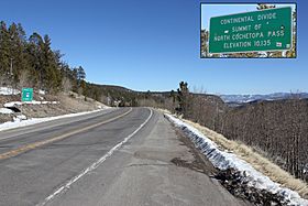
Looking east from the top of the pass. The inset shows the sign on the south side of the pass.
|
|
| Elevation | 10,010 ft (3,051 m) |
| Traversed by | State Highway 114 |
| Location | Saguache County, Colorado, U.S. |
| Range | Cochetopa Hills |
| Coordinates | 38°13′00″N 106°34′32″W / 38.21667°N 106.57556°W |
| Topo map | USGS North Pass |
North Pass (elevation: 10,010 ft (3,050 m)) is a mountain pass over the Continental Divide in Saguache County, Colorado. The pass is traversed by Colorado State Highway 114 between Saguache to the southeast and Gunnison to the northwest. The route is an all-weather paved road.

All content from Kiddle encyclopedia articles (including the article images and facts) can be freely used under Attribution-ShareAlike license, unless stated otherwise. Cite this article:
North Pass Facts for Kids. Kiddle Encyclopedia.