Nordfriesland (district) facts for kids
Quick facts for kids
Nordfriesland
|
|||
|---|---|---|---|
|
|||
| Country | |||
| State | Schleswig-Holstein | ||
| Capital | Husum | ||
| Area | |||
| • Total | 2,047 km2 (790 sq mi) | ||
| Population
(2002)
|
|||
| • Total | 165,800 | ||
| • Density | 81.00/km2 (209.78/sq mi) | ||
| Time zone | UTC+1 (CET) | ||
| • Summer (DST) | UTC+2 (CEST) | ||
| Vehicle registration | NF | ||
| Website | nordfriesland.de | ||
Nordfriesland is the northernmost district of Germany. It is part of the state of Schleswig-Holstein.
The entire coastal region is part of the Schleswig-Holstein Wadden Sea National Park. In the south is the Eiderstedt peninsula, where the River Eider joins the sea. The North Frisian Islands are also part of the Nordfriesland district. There are five large islands (Sylt, Föhr, Amrum, Pellworm and Nordstrand) and ten smaller islets known as Halligen.
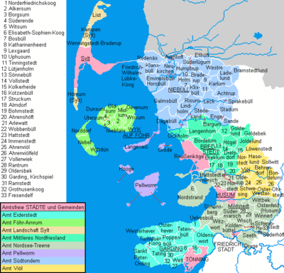
Towns and municipalities
| Independent towns and municipalities |
|---|
|
| Ämter | ||
|---|---|---|
|
|
|
| 1seat of the Amt; 2town | ||
Images for kids
-
Horsecart coming from a Hallig island in the mudflat at low tide
See also
 In Spanish: Distrito de Frisia Septentrional para niños

All content from Kiddle encyclopedia articles (including the article images and facts) can be freely used under Attribution-ShareAlike license, unless stated otherwise. Cite this article:
Nordfriesland (district) Facts for Kids. Kiddle Encyclopedia.


