Nevada County, Arkansas facts for kids
Quick facts for kids
Nevada County
|
|
|---|---|
|
County
|
|

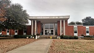
Nevada County Courthouse in Prescott
|
|

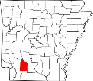
Location within the U.S. state of Arkansas
|
|
 Arkansas's location within the U.S. |
|
| Country | |
| State | |
| Founded | March 20, 1871 |
| Named for | state of Nevada |
| Seat | Prescott |
| Largest city | Prescott |
| Area | |
| • Total | 621 sq mi (1,610 km2) |
| • Land | 618 sq mi (1,600 km2) |
| • Water | 2.8 sq mi (7 km2) 0.5%% |
| Population
(2020)
|
|
| • Total | 8,310 |
| • Density | 13.382/sq mi (5.167/km2) |
| Time zone | UTC−6 (Central) |
| • Summer (DST) | UTC−5 (CDT) |
| Congressional district | 4th |
Nevada County (/nəˈveɪ.də/ nə-VAY-də) is a county located in the southwestern part of the U.S. state of Arkansas. As of the 2020 Census, the population was 8,310, less than half of its peak in 1920. The county seat is Prescott. Nevada County is Arkansas's 63rd county, formed during the Reconstruction era on March 20, 1871, from portions of Hempstead, Ouachita and Columbia counties. It was named after the state of Nevada because of the perceived similarity between their physical shapes; the Arkansas county's shape, inverted, roughly follows the same outline as the state's boundary. It is an alcohol prohibition or dry county.
Contents
History
This area was historically occupied by members of the Caddoan Confederacy, whose territory extended into present-day Texas and Louisiana. They settled along the waterways, using them for transportation and fishing. Colonial French and later European-American settlers also took over lands along the waterways, which formed their basic transportation routes well into the 19th century. After the Congress repealed Prohibition in the early 20th century, Nevada County voted to retain it and the county is still "dry."
Geography
According to the U.S. Census Bureau, the county has a total area of 621 square miles (1,610 km2), of which 618 square miles (1,600 km2) is land and 2.8 square miles (7.3 km2) (0.5%) is water. The county is bounded on the north by the Little Missouri River, a branch of the Ouachita River, and drained by several tributaries of that stream and of Red River. Nevada County is alternately considered as part of the greater regions of South Arkansas or Southwest Arkansas.
Major highways
 Interstate 30
 U.S. Highway 67
 U.S. Highway 278
 U.S. Highway 371
 Highway 19
 Highway 24
 Highway 32
 Highway 51
 Highway 53
Adjacent counties
- Clark County (northeast)
- Ouachita County (east)
- Columbia County (south)
- Lafayette County (southwest)
- Hempstead County (west)
- Pike County (northwest)
Demographics
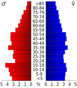
The population declined by more than half from 1920 to 1970, due to mechanization of agriculture and the decline of the lumber industry causing loss of jobs. In addition, blacks left in the Great Migration to midwestern and western industrial cities, where they found better work and less social oppression.
| Historical population | |||
|---|---|---|---|
| Census | Pop. | %± | |
| 1880 | 12,959 | — | |
| 1890 | 14,832 | 14.5% | |
| 1900 | 16,609 | 12.0% | |
| 1910 | 19,344 | 16.5% | |
| 1920 | 21,934 | 13.4% | |
| 1930 | 20,407 | −7.0% | |
| 1940 | 19,869 | −2.6% | |
| 1950 | 14,781 | −25.6% | |
| 1960 | 10,700 | −27.6% | |
| 1970 | 10,111 | −5.5% | |
| 1980 | 11,097 | 9.8% | |
| 1990 | 10,101 | −9.0% | |
| 2000 | 9,955 | −1.4% | |
| 2010 | 8,997 | −9.6% | |
| 2020 | 8,310 | −7.6% | |
| 2023 (est.) | 8,120 | −9.7% | |
| U.S. Decennial Census 1790–1960 1900–1990 1990–2000 2010 |
|||
2020 census
| Race | Num. | Perc. |
|---|---|---|
| White (non-Hispanic) | 5,145 | 61.91% |
| Black or African American (non-Hispanic) | 2,433 | 29.28% |
| Native American | 37 | 0.45% |
| Asian | 41 | 0.49% |
| Other/Mixed | 300 | 3.61% |
| Hispanic or Latino | 354 | 4.26% |
As of the 2020 United States census, there were 8,310 people, 3,397 households, and 2,263 families residing in the county.
Communities
Cities
Towns
- Bluff City
- Bodcaw
- Cale
- Rosston
- Willisville
- Falcon
Census-designated place
Townships
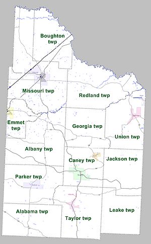
Townships in Arkansas are the divisions of a county. Each township includes unincorporated areas; some may have incorporated cities or towns within part of their boundaries. Arkansas townships have limited purposes in modern times. However, the United States Census does list Arkansas population based on townships (sometimes referred to as "county subdivisions" or "minor civil divisions"). Townships are also of value for historical purposes in terms of genealogical research. Each town or city is within one or more townships in an Arkansas county based on census maps and publications. The townships of Nevada County are listed below; listed in parentheses are the cities, towns, and/or census-designated places that are fully or partially inside the township.
- Alabama
- Albany
- Boughton
- Caney (Cale, Rosston)
- Emmet (Emmet)
- Georgia
- Jackson
- Leake
- Missouri (Prescott)
- Parker (Bodcaw)
- Redland
- Taylor (Willisville)
- Union (Bluff City, Reader)
See also
 In Spanish: Condado de Nevada (Arkansas) para niños


