Neighborhoods in Providence, Rhode Island facts for kids
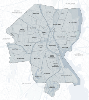
The city of Providence, Rhode Island has 25 official neighborhoods.
- Blackstone
- Charles
- College Hill
- Downtown
- Elmhurst
- Elmwood
- Federal Hill
- Fox Point
- Hartford
- Hope (Summit)
- Lower South Providence
- Manton
- Mount Hope
- Mount Pleasant
- Olneyville
- Reservoir
- Silver Lake
- Smith Hill
- South Elmwood
- Upper South Providence
- Valley
- Wanskuck
- Washington Park
- Wayland
- West End
Regions
Many of these neighborhoods are often grouped together referred to collectively:
- East Side – Blackstone, Hope, Mount Hope, College Hill, Wayland, and Fox Point.
- North End – Charles, Wanskuck, Smith Hill, Elmhurst, and Mount Pleasant.
- South Side or South Providence – Elmwood, Lower South Providence, Upper South Providence, West End, and Washington Park.

The Jewelry District occupies the southern portion of Downtown Providence. Since the area was re-united with Downtown following the relocation of Interstate 195, the city has been working to attract high-tech and research companies to this area under the rebranded name of "Knowledge District." This area is not recognized as one of Providence's 25 official neighborhoods. The Hospital District, a non-residential area within Upper South Providence is similarly unrecognized.
The oldest, highest density neighborhoods are either those close to Downtown or proximate to the Woonasquatucket River, which provided a power source for early industrialization in Manton, Hartford, and Olneyville. More distant neighborhoods developed later, mostly as transportation as public horse car and streetcar lines were added.
-
College Hill, on Providence's East Side overlooks Downtown
-
Smith Hill forms one of the neighborhoods on Providence's North End
-
Elmwood is part of Providence's South Side


