National Register of Historic Places listings in Washington County, Nebraska facts for kids
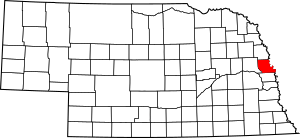
This is a list of the National Register of Historic Places listings in Washington County, Nebraska.
This is intended to be a complete list of the properties and districts on the National Register of Historic Places in Washington County, Nebraska, United States. The locations of National Register properties and districts for which the latitude and longitude coordinates are included below, may be seen in a map.
There are 16 properties and districts listed on the National Register in the county, including 1 National Historic Landmark. There are also two former listings.
Current listings
| Name on the Register | Image | Date listed | Location | City or town | Description | |
|---|---|---|---|---|---|---|
| 1 | Bertrand Site |
(#69000138) |
DeSoto National Wildlife Refuge 41°31′24″N 96°01′44″W / 41.523333°N 96.028889°W |
Blair | ||
| 2 | Blair High School |
(#91000300) |
Junction of 16th and Colfax Sts. 41°32′24″N 96°08′10″W / 41.54°N 96.136111°W |
Blair | ||
| 3 | Abraham Castetter House |
(#82003203) |
1815 Grant St. 41°32′30″N 96°08′23″W / 41.54159°N 96.13967°W |
Blair | ||
| 4 | Congregational Church of Blair |
(#79001457) |
16th and Colfax Sts. 41°32′27″N 96°08′11″W / 41.540972°N 96.136444°W |
Blair | ||
| 5 | C.C. Crowell, Jr. House |
(#82003204) |
2138 Washington St. 41°32′39″N 96°08′42″W / 41.5441°N 96.14505°W |
Blair | ||
| 6 | Engineer Cantonment |
(#15000795) |
Address restricted |
Fort Calhoun | ||
| 7 | Fontanelle Township Hall |
(#82003205) |
10976 8th Street 41°32′14″N 96°25′40″W / 41.537361°N 96.427667°W |
Fontanelle | ||
| 8 | Fort Atkinson |
(#66000454) |
1 mile east of Fort Calhoun 41°27′23″N 96°00′49″W / 41.456389°N 96.013611°W |
Fort Calhoun | ||
| 9 | Alfred H. and Sarah Frahm House |
(#06000101) |
220 S. 15th St. 41°27′14″N 96°01′41″W / 41.45398°N 96.02803°W |
Fort Calhoun | ||
| 10 | Gottsch Farmstead |
(#16000516) |
17201 Dutch Hall Rd. 41°23′35″N 96°11′02″W / 41.393150°N 96.184008°W |
Bennington | ||
| 11 | Long Creek School |
(#01000167) |
Long Creek Lane 41°27′33″N 96°05′15″W / 41.4591°N 96.08748°W |
Blair | ||
| 12 | Old McDonald Farm |
(#01000714) |
2 miles (3.2 km) south of Blair above Mill Creek 41°30′01″N 96°08′00″W / 41.500278°N 96.133333°W |
Blair | ||
| 13 | Frank Parker Archeological Site |
(#09000069) |
Address restricted |
Fort Calhoun | Extends into Douglas County | |
| 14 | Trinity Seminary Building |
(#80004528) |
College Dr. 41°33′02″N 96°08′39″W / 41.550556°N 96.144167°W |
Blair | Destroyed by fire in August 1988 | |
| 15 | Washington County Courthouse |
(#89002221) |
16th St. between Colfax and South Sts. 41°32′24″N 96°08′06″W / 41.54°N 96.135°W |
Blair |
Former listings
| Name on the Register | Image | Date listed | Date removed | Location | City or town | Summary | |
|---|---|---|---|---|---|---|---|
| 1 | Crowell Mansion |
(#71001085) |
|
245 S. 22nd St. 33°26′41″N 112°03′54″W / 33.444722°N 112.065°W |
Blair | Demolished in 1971 |

All content from Kiddle encyclopedia articles (including the article images and facts) can be freely used under Attribution-ShareAlike license, unless stated otherwise. Cite this article:
National Register of Historic Places listings in Washington County, Nebraska Facts for Kids. Kiddle Encyclopedia.


