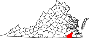
National Register of Historic Places listings in Southampton County, Virginia facts for kids
This is a list of the National Register of Historic Places listings in Southampton County, Virginia.
This is intended to be a complete list of the properties and districts on the National Register of Historic Places in Southampton County, Virginia, United States. The locations of National Register properties and districts for which the latitude and longitude coordinates are included below, may be seen in an online map.
There are 18 properties and districts listed on the National Register in the county.
Current listings
| Name on the Register | Image | Date listed | Location | City or town | Description | |
|---|---|---|---|---|---|---|
| 1 | Aspen Lawn |
(#02000319) |
4438 Hicksford Rd. 36°40′45″N 77°25′48″W / 36.679028°N 77.430000°W |
Drewryville | ||
| 2 | Beaton-Powell House |
(#08001058) |
32142 South Main St. 36°35′00″N 77°12′02″W / 36.583333°N 77.200556°W |
Boykins | ||
| 3 | Beechwood |
(#79003088) |
NE of Courtland on VA 643 36°45′11″N 77°00′05″W / 36.753056°N 77.001389°W |
Beales | ||
| 4 | Belmont |
(#73002061) |
Northeast of Capron off VA 652 36°43′39″N 77°10′08″W / 36.727500°N 77.168889°W |
Capron | ||
| 5 | Brown's Ferry |
(#79003090) |
East of Drakes Corner off VA 684 36°36′41″N 77°00′04″W / 36.611389°N 77.001111°W |
Drakes Corner | ||
| 6 | Courtland School |
(#16000539) |
25499 Florence St. 36°43′18″N 77°04′01″W / 36.721667°N 77.067083°W |
Courtland | ||
| 7 | Elm Grove |
(#79003089) |
Northeast of Courtland on VA 646 36°44′39″N 77°01′39″W / 36.744167°N 77.027500°W |
Courtland | ||
| 8 | Mahone's Tavern |
(#08000483) |
22341 Main St. 36°42′51″N 77°04′01″W / 36.714167°N 77.066944°W |
Courtland | Childhood home of Confederate General William Mahone | |
| 9 | Rochelle-Prince House |
(#10001115) |
22371 Main St. 36°42′48″N 77°04′00″W / 36.713472°N 77.066528°W |
Courtland | James Rochelle was clerk of the Southampton County court during the trial of Nat Turner. His nephew was George Henry Thomas, a Union general in the American Civil War. | |
| 10 | Rose Hill |
(#79003087) |
Northeast of Capron on VA 635 36°44′47″N 77°08′01″W / 36.746389°N 77.133611°W |
Capron | ||
| 11 | Sebrell Rural Historic District |
(#13000648) |
Roughly bounded by the Nottoway River, the Assamoosick Swamp, and Old Hickory Rd. 36°47′07″N 77°07′34″W / 36.785278°N 77.126111°W |
Sebrell | ||
| 12 | Simmons-Sebrell-Camp House |
(#03001097) |
Zebulon Simmons Tract 36°47′21″N 77°08′03″W / 36.789167°N 77.134167°W |
Courtland | ||
| 13 | Sunnyside |
(#82004596) |
VA 673 36°38′37″N 77°08′36″W / 36.643611°N 77.143333°W |
Newsoms | ||
| 14 | Rebecca Vaughan House |
(#06000162) |
26315 Heritage Ln. 36°42′39″N 77°03′27″W / 36.710972°N 77.057500°W |
Courtland | The last house in which anyone was killed during the Southampton Insurrection of 1831 | |
| 15 | William H. Vincent House |
(#03001444) |
23016 Main St. 36°42′38″N 77°12′02″W / 36.710556°N 77.200556°W |
Capron |

All content from Kiddle encyclopedia articles (including the article images and facts) can be freely used under Attribution-ShareAlike license, unless stated otherwise. Cite this article:
National Register of Historic Places listings in Southampton County, Virginia Facts for Kids. Kiddle Encyclopedia.


