National Register of Historic Places listings in Sandusky County, Ohio facts for kids
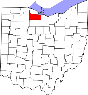
This is a list of the National Register of Historic Places listings in Sandusky County, Ohio.
This is intended to be a complete list of the properties and districts on the National Register of Historic Places in Sandusky County, Ohio, United States. The locations of National Register properties and districts for which the latitude and longitude coordinates are included below, may be seen in a Google map.
There are 12 properties and districts listed on the National Register in the county, including 1 National Historic Landmark. Another property was once listed but has been removed.
Current listings
| Name on the Register | Image | Date listed | Location | City or town | Description | |
|---|---|---|---|---|---|---|
| 1 | Joseph and Rachel Bartlett House |
(#90000388) |
212 S. Park Ave. 41°20′42″N 83°07′03″W / 41.345000°N 83.117500°W |
Fremont | ||
| 2 | Ralph P. Buckland House |
(#74001620) |
300 S. Park Ave. 41°20′38″N 83°07′04″W / 41.344027°N 83.117778°W |
Fremont | ||
| 3 | Georg Cronenwett House |
(#78002184) |
606 W. Main St. 41°27′11″N 83°22′07″W / 41.453055°N 83.368611°W |
Woodville | ||
| 4 | Frederick Fabing House |
(#83002054) |
201 S. Park Ave. 41°20′43″N 83°07′01″W / 41.345277°N 83.116944°W |
Fremont | ||
| 5 | Rutherford B. Hayes House |
(#66000624) |
Hayes and Buckland Aves. 41°20′27″N 83°07′50″W / 41.340833°N 83.130556°W |
Fremont | ||
| 6 | Christopher C. Layman Law Office |
(#86001062) |
212 W. 1st St. 41°27′08″N 83°21′52″W / 41.452333°N 83.364444°W |
Woodville | ||
| 7 | Maj. Gen. James B. McPherson House |
(#74001619) |
300 E. McPherson Highway 41°18′31″N 82°58′17″W / 41.308611°N 82.971389°W |
Clyde | ||
| 8 | Mull Covered Bridge |
(#74001618) |
East of Burgoon between State Routes 12 and 53 41°15′39″N 83°11′04″W / 41.260833°N 83.184444°W |
Ballville Township | ||
| 9 | Overmyer-Waggoner-Roush Farm |
(#83002055) |
654 S. Main St. 41°24′39″N 83°13′18″W / 41.410833°N 83.221667°W |
Lindsey | ||
| 10 | St. Paul's Episcopal Church |
(#77001085) |
200 N. Park Ave. 41°20′51″N 83°07′03″W / 41.347500°N 83.117500°W |
Fremont | ||
| 11 | Sandusky County Jail and Sheriff's House |
(#97000198) |
622 Croghan St. 41°20′49″N 83°07′06″W / 41.346944°N 83.118333°W |
Fremont | ||
| 12 | Soldiers Memorial Parkway and McKinley Memorial Parkway |
(#90002212) |
Soldiers Memorial Parkway and McKinley Memorial Parkway 41°20′24″N 83°07′59″W / 41.34°N 83.133056°W |
Fremont |
Former listing
| Name on the Register | Image | Date listed | Date removed | Location | City or town | Summary | |
|---|---|---|---|---|---|---|---|
| 1 | Fremont City Hall |
(#78002183) |
|
401 Croghan St. |
Fremont |

All content from Kiddle encyclopedia articles (including the article images and facts) can be freely used under Attribution-ShareAlike license, unless stated otherwise. Cite this article:
National Register of Historic Places listings in Sandusky County, Ohio Facts for Kids. Kiddle Encyclopedia.


