National Register of Historic Places listings in Middlesex County, Virginia facts for kids
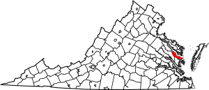
This is a list of the National Register of Historic Places listings in Middlesex County, Virginia.
This is intended to be a complete list of the properties and districts on the National Register of Historic Places in Middlesex County, Virginia, United States. The locations of National Register properties and districts for which the latitude and longitude coordinates are included below, may be seen in an online map.
There are 16 properties and districts listed on the National Register in the county.
Current listings
| Name on the Register | Image | Date listed | Location | City or town | Description | |
|---|---|---|---|---|---|---|
| 1 | Christ Church |
(#72001408) |
Off VA 638, north of the junction with VA 33 37°36′35″N 76°32′47″W / 37.609722°N 76.546389°W |
Saluda | ||
| 2 | Deer Chase |
(#73002039) |
Southeast of Saluda off VA 629 37°34′21″N 76°32′25″W / 37.572500°N 76.540278°W |
Saluda | ||
| 3 | Hewick |
(#78003030) |
Northwest of Urbanna 37°38′33″N 76°35′13″W / 37.642500°N 76.586944°W |
Urbanna | ||
| 4 | F.D. CROCKETT (log deck boat) |
(#12000544) |
287 Jackson Creek Rd. 37°33′08″N 76°19′22″W / 37.552222°N 76.322639°W |
Deltaville | ||
| 5 | Lansdowne |
(#74002138) |
Virginia St. at Upton Lane 37°38′12″N 76°34′36″W / 37.636667°N 76.576667°W |
Urbanna | ||
| 6 | Lower Church |
(#73002038) |
West of Hartfield on VA 33 37°33′08″N 76°27′34″W / 37.552222°N 76.459444°W |
Hartfield | ||
| 7 | Middlesex County Courthouse |
(#76002114) |
Approximately 200 feet (61 m) northeast of the junction of US 17/VA 33 and VA 618 37°36′24″N 76°35′41″W / 37.606667°N 76.594722°W |
Saluda | Built 1852; a late but significant example of an arcade-plan civic building. | |
| 8 | Middlesex County Courthouse |
(#78003029) |
Off VA 602 37°38′11″N 76°34′31″W / 37.636389°N 76.575278°W |
Urbanna | One of Virginia's eleven colonial courthouse buildings, built starting about 1745. | |
| 9 | James Mills Storehouse |
(#72001409) |
South side of Route T-1002 37°38′12″N 76°34′23″W / 37.636528°N 76.573056°W |
Urbanna | ||
| 10 | Prospect |
(#04000480) |
2847 Grey's Point Rd. 37°36′02″N 76°26′40″W / 37.600417°N 76.444306°W |
Topping | ||
| 11 | Rosegill |
(#73002040) |
East of Urbanna off VA 227 37°38′07″N 76°33′55″W / 37.635278°N 76.565278°W |
Urbanna | ||
| 12 | Sandwich |
(#08000390) |
131 Virginia St. 37°38′13″N 76°34′23″W / 37.636806°N 76.573056°W |
Urbanna | ||
| 13 | Urbanna Historic District |
(#90002196) |
Roughly bounded by Virginia St., Rappahannock Ave., Watling St. and Urbanna Cr. 37°38′12″N 76°34′29″W / 37.636667°N 76.574722°W |
Urbanna | ||
| 14 | Wilton |
(#79003055) |
South of Wilton on State Route 3 37°31′47″N 76°25′24″W / 37.529722°N 76.423333°W |
Wilton | ||
| 15 | Wormeley Cottage |
(#80004201) |
Virginia St. 37°38′09″N 76°34′41″W / 37.635833°N 76.578056°W |
Urbanna |

All content from Kiddle encyclopedia articles (including the article images and facts) can be freely used under Attribution-ShareAlike license, unless stated otherwise. Cite this article:
National Register of Historic Places listings in Middlesex County, Virginia Facts for Kids. Kiddle Encyclopedia.


