National Register of Historic Places listings in Howell County, Missouri facts for kids
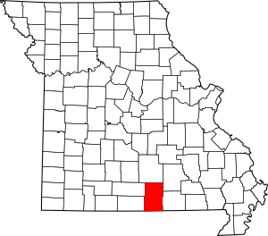
This is a list of the National Register of Historic Places listings in Howell County, Missouri.
This is intended to be a complete list of the properties and districts on the National Register of Historic Places in Howell County, Missouri, United States. Latitude and longitude coordinates are provided for many National Register properties and districts; these locations may be seen together in a map.
There are 6 properties and districts listed on the National Register in the county.
Current listings
| Name on the Register | Image | Date listed | Location | City or town | Description | |
|---|---|---|---|---|---|---|
| 1 | Courthouse Square Historic District |
(#03000651) |
Roughly bounded by Broadway, Grove St., Court Sq. and Washington Ave. 36°43′43″N 91°51′08″W / 36.728611°N 91.852222°W |
West Plains | ||
| 2 | Elledge Arcade Buildings |
(#01000011) |
28 Court Sq. and 2 Elledge Arcade 36°43′43″N 91°51′10″W / 36.728611°N 91.852778°W |
West Plains | ||
| 3 | International Shoe Company Building |
(#11000783) |
665 Missouri Ave. 36°44′05″N 91°51′31″W / 36.734817°N 91.858728°W |
West Plains | ||
| 4 | Mount Zion Lodge Masonic Temple |
(#11000188) |
304 E. Main St. 36°43′41″N 91°51′01″W / 36.728056°N 91.850278°W |
West Plains | ||
| 5 | W. J. and Ed Smith Building |
(#01000012) |
109-113 Washington Ave. 36°43′44″N 91°51′09″W / 36.728889°N 91.8525°W |
West Plains | ||
| 6 | West Plains Bank Building |
(#01000013) |
107 Washington Ave. 36°43′44″N 91°51′09″W / 36.728889°N 91.8525°W |
West Plains |

All content from Kiddle encyclopedia articles (including the article images and facts) can be freely used under Attribution-ShareAlike license, unless stated otherwise. Cite this article:
National Register of Historic Places listings in Howell County, Missouri Facts for Kids. Kiddle Encyclopedia.


