National Register of Historic Places listings in Emporia, Virginia facts for kids
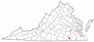
This is a list of the National Register of Historic Places listings in Emporia, Virginia.
This is intended to be a complete list of the properties and districts on the National Register of Historic Places in the independent city of Emporia, Virginia, United States. The locations of National Register properties and districts for which the latitude and longitude coordinates are included below, may be seen in a Google map.
There are 7 properties and districts listed on the National Register in the city.
Current listings
| Name on the Register | Image | Date listed | Location | Description | |
|---|---|---|---|---|---|
| 1 | Belfield-Emporia Historic District |
(#07001137) |
Roughly bounded by the Petersburg & Danville railroad line, Atlantic Ave., and Budd and Valley Sts. 36°41′36″N 77°32′16″W / 36.693333°N 77.537778°W |
||
| 2 | Greensville County Courthouse Complex |
(#83003279) |
S. Main St. 36°41′11″N 77°32′32″W / 36.686389°N 77.542222°W |
||
| 3 | Greensville County Training School |
(#06000122) |
105 Ruffin St. 36°41′56″N 77°32′07″W / 36.698889°N 77.535278°W |
||
| 4 | Hicksford-Emporia Historic District |
(#07001217) |
S. Main St. and Brunswick Ave. 36°41′12″N 77°32′34″W / 36.686667°N 77.542778°W |
||
| 5 | H. T. Klugel Architectural Sheet Metal Work Building |
(#73002208) |
135 Atlantic Ave. 36°41′40″N 77°32′11″W / 36.694444°N 77.536389°W |
||
| 6 | Old Merchants and Farmers Bank Building |
(#79003278) |
419 S. Main St. 36°41′08″N 77°32′35″W / 36.685417°N 77.542917°W |
||
| 7 | Village View |
(#82004554) |
221 Briggs St. 36°40′51″N 77°32′34″W / 36.680833°N 77.542778°W |

All content from Kiddle encyclopedia articles (including the article images and facts) can be freely used under Attribution-ShareAlike license, unless stated otherwise. Cite this article:
National Register of Historic Places listings in Emporia, Virginia Facts for Kids. Kiddle Encyclopedia.


