National Register of Historic Places listings in Barton County, Kansas facts for kids
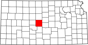
This is a list of the National Register of Historic Places listings in Barton County, Kansas.
This is intended to be a complete list of the properties on the National Register of Historic Places in Barton County, Kansas, United States. The locations of National Register properties for which the latitude and longitude coordinates are included below, may be seen in a map.
There are 19 properties listed on the National Register in the county. Three properties were once listed, but have since been removed.
Current listings
| Name on the Register | Image | Date listed | Location | City or town | Description | |
|---|---|---|---|---|---|---|
| 1 | Abel House |
(#01000180) |
2601 Passeo 38°22′39″N 98°46′21″W / 38.3775°N 98.7725°W |
Great Bend | ||
| 2 | Beaver Creek Native Stone Bridge |
(#08000296) |
NE. 50 Ave. S. and NE 230 Rd. 38°41′41″N 98°40′57″W / 38.694722°N 98.6825°W |
Beaver | ||
| 3 | Bridge No. 218-Off System Bridge |
(#08000297) |
NE. 60 Ave. S. and NE. 220 Rd. 38°40′53″N 98°39′58″W / 38.681389°N 98.666111°W |
Beaver | ||
| 4 | Bridge No. 222-Off System Bridge |
(#08000608) |
NE. 60 Ave., S. and NE. 210 Rd., 1/8 mile east on 210 Rd. 38°41′01″N 98°39′49″W / 38.683611°N 98.663611°W |
Beaver | ||
| 5 | Bridge No. 640-Federal Aid Highway System Bridge |
(#08000611) |
NE 60 Ave., 1/8 mile north of NE 210 Rd. 38°40′06″N 98°39′50″W / 38.668333°N 98.663889°W |
Beaver | ||
| 6 | Bridge No. 650-Federal Aid Highway System Bridge |
(#08000612) |
NE 60 Ave., 1/12 mile south of NE 220 Rd. 38°40′48″N 98°39′50″W / 38.68°N 98.663889°W |
Beaver | ||
| 7 | Crest Theater |
(#05000003) |
1905 Lakin Ave. 38°21′59″N 98°45′50″W / 38.366389°N 98.763889°W |
Great Bend | ||
| 8 | Great Bend Army Air Field Hanger |
(#15000686) |
9047 6th St. 38°20′49″N 98°51′10″W / 38.347°N 98.8528°W |
Great Bend | ||
| 9 | Hoisington High School |
(#05001248) |
218 E. 7th St. 38°31′19″N 98°46′34″W / 38.521944°N 98.776111°W |
Hoisington | ||
| 10 | Manweiler-Maupin Chevrolet |
(#12000842) |
271 S. Main St. 38°30′43″N 98°46′39″W / 38.512003°N 98.77743°W |
Hoisington | Part of the Roadside Kansas MPS | |
| 11 | Nagel House |
(#01000181) |
1411 Wilson St. 38°21′57″N 98°47′42″W / 38.365833°N 98.795°W |
Great Bend | ||
| 12 | Norden Bombsight Storage Vaults |
(#15000687) |
9047 6th St. 38°20′49″N 98°51′13″W / 38.3469°N 98.8535°W |
Great Bend | ||
| 13 | Pawnee Rock |
(#70000247) |
0.2 miles north of Pawnee Rock off U.S. 56 38°16′20″N 98°58′53″W / 38.272222°N 98.981389°W |
Pawnee Rock | ||
| 14 | US Post Office-Hoisington |
(#89001642) |
121 E. 2nd St. 38°30′52″N 98°46′34″W / 38.514444°N 98.776111°W |
Hoisington | ||
| 15 | Walnut Creek Bridge |
(#89002178) |
Over Walnut Creek, northwest of Heizer 38°25′54″N 98°53′40″W / 38.431667°N 98.894444°W |
Heizer | ||
| 16 | Walnut Creek Crossing |
(#72000488) |
Along Walnut Creek above its confluence with the Arkansas River, east of Great Bend 38°21′28″N 98°42′07″W / 38.3578°N 98.7019°W |
Great Bend Township | ||
| 17 | Wolf Hotel |
(#02001295) |
104 E. Santa Fe 38°21′13″N 98°34′50″W / 38.353611°N 98.580556°W |
Ellinwood | ||
| 18 | Wolf Park Band Shell |
(#03000706) |
Lots 12 and 13, Block 2, 200 block of N. Main 38°21′23″N 98°34′49″W / 38.356389°N 98.580278°W |
Ellinwood |
Former listings
| Name on the Register | Image | Date listed | Date removed | Location | City or town | Summary | |
|---|---|---|---|---|---|---|---|
| 1 | Hitschmann Cattle Underpass Bridge |
(#08000298) |
|
NE. 110 Ave. S. & NE. 190 Rd. 38°38′16″N 98°34′20″W / 38.637778°N 98.572222°W |
Hitschmann | ||
| 2 | Hitschmann Double Arch Bridge |
(#08000299) |
|
NE. 110 Ave. S. & NE. 190 Rd. 38°38′16″N 98°34′20″W / 38.637778°N 98.572222°W |
Hitschmann |

All content from Kiddle encyclopedia articles (including the article images and facts) can be freely used under Attribution-ShareAlike license, unless stated otherwise. Cite this article:
National Register of Historic Places listings in Barton County, Kansas Facts for Kids. Kiddle Encyclopedia.


