Mullaghmore, County Londonderry facts for kids
Quick facts for kids Mullaghmore |
|
|---|---|
| an Mullach Mór | |
 |
|
| Highest point | |
| Elevation | 550 m (1,800 ft) |
| Prominence | 235 m (771 ft) |
| Listing | Marilyn |
| Geography | |
| Location | County Londonderry, Northern Ireland |
| Parent range | Sperrin Mountains |
| OSI/OSNI grid | C739008 |
| Topo map | OSNI Discoverer Series 8 (1:50000) |
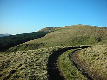
Mullaghmore (from Irish an Mullach Mór, meaning 'the big summit') is a mountain in County Londonderry, Northern Ireland. It is part of the Sperrins and the 359th highest point on the island of Ireland The summit is dominated by a large telecommunication tower. The peak is located 5 miles north of the village of Draperstown, and 6 miles south of Dungiven. It is also locally known as, "The Birren" hence the road name passing over it is "Birren Road"

All content from Kiddle encyclopedia articles (including the article images and facts) can be freely used under Attribution-ShareAlike license, unless stated otherwise. Cite this article:
Mullaghmore, County Londonderry Facts for Kids. Kiddle Encyclopedia.