Mount Quincy Adams (Fairweather Range) facts for kids
Quick facts for kids Mount Quincy Adams |
|
|---|---|

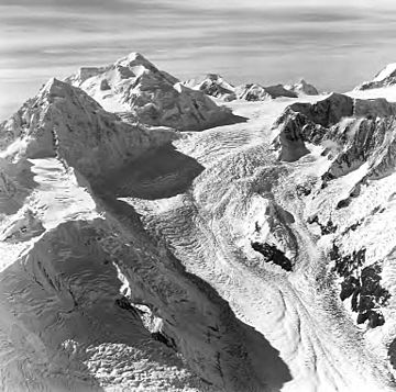
Mount Quincy Adams in upper left, with Mount Tlingit below/left of it. Aerial view by Austin Post. 1972
|
|
| Highest point | |
| Elevation | 4,150 m (13,620 ft) |
| Prominence | 410 m (1,350 ft) |
| Geography | |
| Parent range | Fairweather Range |
| Topo map | USGS Mount Fairweather D-5 |
| Climbing | |
| First ascent | Bradford Washburn, H. Adams Carter, 1934 |
Mount Quincy Adams (alternate Name Boundary Peak 163) is a mountain located on the border between United States and Canada. It is named after John Quincy Adams (1767–1848), the sixth president of the United States.
The southern and eastern flanks of the mountain are in Glacier Bay National Park, in Hoonah-Angoon Census Area, Alaska. The northern and northwestern flanks are in Tatshenshini-Alsek Park, in Stikine Region, British Columbia, making it the second highest peak in B.C. Mount Quincy Adams is flanked to the west by Mount Fairweather 4,671 m (15,325 ft).

All content from Kiddle encyclopedia articles (including the article images and facts) can be freely used under Attribution-ShareAlike license, unless stated otherwise. Cite this article:
Mount Quincy Adams (Fairweather Range) Facts for Kids. Kiddle Encyclopedia.

