Mount Pico facts for kids
Quick facts for kids Mount Pico |
|
|---|---|
| Montanha do Pico | |

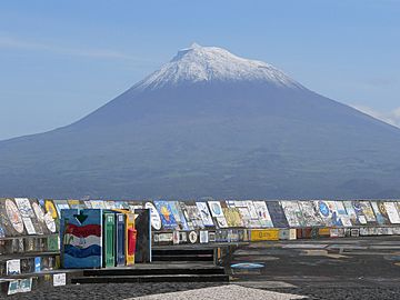
View of Pico from the harbour of Horta (Faial)
|
|
| Highest point | |
| Elevation | 2,351 m (7,713 ft) |
| Parent peak | None |
| Geography | |
| Location | |
| State/Province | PT |
| Parent range | Mid-Atlantic Ridge |
| Geology | |
| Age of rock | < 230,000 Years |
| Mountain type | Stratovolcano |
| Last eruption | 1718 |
Mount Pico (Portuguese: Montanha do Pico) is a composite volcano (or stratovolcano); it is the highest point of the Portuguese island of Pico in the Azores. With an altitude of 2,351 m (7,713 ft) above sea level, it is more than twice the elevation of any other peak in the Azores, and the tallest mountain in Portugal.
Description
Mount Pico is at the eastern end of Pico Island. On the top of the mountain, there is round crater about 500 m (1,600 ft) in diameter and 300 m (980 ft) deep. Inside this crater (Portuguese: Pico Alto) there is a small elevation produced by a recent, in geological terms, eruption that is known with the name of Pico Pequeno or Piquinho, which is about 70 metres (230 ft) high. From the base of Pico Pequeno, volcanic smoke gets out with a strong odor of sulfur.
In winter, the top of the mountain is covered with snow. Rains are frequent the whole year.
Reserve and hiking
Mount Pico was made a Natural Reserve in 1982 to protect the mountain. The reserve (Portuguese: Reserva Natural da Montanha do Pico) has an area of about 1,500 hectares (15 km2) and is from about 1,200 m (3,937 ft) high to the top of the mountain.
There are trails for hiking and it is possible, for persons in good conditions and depending on weather, to get to the top of the mountain in around two to four hours from the beginning of the trail.
In the lower part of its slopes is the Paisagem da Cultura da Vinha da Ilha do Pico (Landscape of the Pico Island Vineyard Culture), classified by UNESCO as a World Heritage.
Images for kids
See also
 In Spanish: Montaña del Pico para niños


