Mount Bullion, Mariposa County, California facts for kids
Quick facts for kids
Mount Bullion
|
|
|---|---|

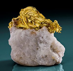
Gold on quartz, Mockingbird Mine near Mt. Bullion
|
|
| Country | United States |
| State | California |
| County | Mariposa |
| Area | |
| • Total | 0.611 sq mi (1.58 km2) |
| • Land | 0.610 sq mi (1.58 km2) |
| • Water | 0.001 sq mi (0.003 km2) |
| Elevation | 2,152 ft (656 m) |
| Population
(2020)
|
|
| • Total | 154 |
| • Density | 252.5/sq mi (97.5/km2) |
| Time zone | UTC-8 (Pacific (PST)) |
| • Summer (DST) | UTC-7 (PDT) |
| ZIP Code |
95338 (Mariposa)
|
| GNIS feature IDs | 233575; 2812657 |
Mount Bullion (formerly, Princeton and La Mineta) is an unincorporated community and census-designated place (CDP) in Mariposa County, California, United States. As of the 2020 United States census, it had a population of 154.
A post office operated at Mount Bullion from 1862 to 1955, with a closure for a period during 1887. The place was first named "La Mineta" (for "little mine"). Then it was called "Princeton" for the Princeton Mine nearby. Finally, the name "Mount Bullion" was applied in honor of Senator Thomas Hart Benton, whose nickname was "Old Bullion" due to his fiscal policies.
Geography
The community is in west-central Mariposa County, along California State Route 49. It is 5 miles (8 km) northwest of Mariposa, the county seat, and 6 miles (10 km) southeast of Bear Valley, at an elevation of 2,152 feet (656 m).
The Mount Bullion CDP has an area of 0.61 square miles (1.58 km2), all but 0.001 square miles (0.003 km2) of it land. The town sits on a low divide between the headwaters of Agua Fria Creek flowing to the southeast and the heads of Norwegian Gulch and Green Gulch, which run west to Bear Creek. Both creek systems find their ways southwest into the San Joaquin Valley.


