Moores Pocket, Queensland facts for kids
Quick facts for kids Moores PocketIpswich, Queensland |
|||||||||||||||
|---|---|---|---|---|---|---|---|---|---|---|---|---|---|---|---|

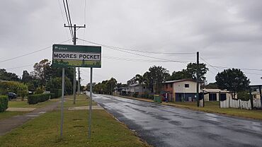
Moores Pocket Road, 2023
|
|||||||||||||||
| Population | 772 (2021 census) | ||||||||||||||
| • Density | 860/km2 (2,200/sq mi) | ||||||||||||||
| Postcode(s) | 4305 | ||||||||||||||
| Area | 0.9 km2 (0.3 sq mi) | ||||||||||||||
| Time zone | AEST (UTC+10:00) | ||||||||||||||
| Location |
|
||||||||||||||
| LGA(s) | City of Ipswich | ||||||||||||||
| State electorate(s) | Ipswich West | ||||||||||||||
| Federal Division(s) | Blair | ||||||||||||||
|
|||||||||||||||
Moores Pocket is a suburb in the City of Ipswich, Queensland, Australia. In the 2021 census, Moores Pocket had a population of 772 people.
Geography
As the name suggests, Moores Pocket is bounded by the winding Bremer River on all sides except the north-west where it is separated from the suburb of Tivoli by Boundary Road.
History
The origin of the suburb name is from Thomas Moore, an early blacksmith in the area.
The suburb was greatly damaged in the 1893 Brisbane River flood.
The suburb was flooded in the 2011 Queensland floods.
Demographics
In the 2016 census, the locality of Moores Pocket had a population of 736 people.
In the 2021 census, the locality of Moores Pocket had a population of 772 people.

All content from Kiddle encyclopedia articles (including the article images and facts) can be freely used under Attribution-ShareAlike license, unless stated otherwise. Cite this article:
Moores Pocket, Queensland Facts for Kids. Kiddle Encyclopedia.

