
Montgomery, Michigan facts for kids
Quick facts for kids
Montgomery, Michigan
|
|
|---|---|
|
Village
|
|
| Village of Montgomery | |
.jpg)
Looking east along Hakes Street
|
|

Location within Hillsdale County
|
|

Montgomery, Michigan
Location in Michigan

Montgomery, Michigan
Location in the United States
|
|
| Country | United States |
| State | Michigan |
| County | Hillsdale |
| Township | Camden |
| Settled | 1870 |
| Platted | 1871 |
| Incorporated | 1906 |
| Government | |
| • Type | Village council |
| Area | |
| • Total | 1.00 sq mi (2.60 km2) |
| • Land | 1.00 sq mi (2.60 km2) |
| • Water | 0.00 sq mi (0.00 km2) |
| Elevation | 1,050 ft (320 m) |
| Population
(2020)
|
|
| • Total | 322 |
| • Density | 322.00/sq mi (124.32/km2) |
| Time zone | UTC-5 (Eastern (EST)) |
| • Summer (DST) | UTC-4 (EDT) |
| ZIP code(s) |
49255
49274 (Reading) |
| Area code(s) | 517 |
| FIPS code | 26-55220 |
| GNIS feature ID | 0632603 |
Montgomery is a village in Hillsdale County in the U.S. state of Michigan. The population was 322 at the 2020 census. The village is located within Camden Township.
History
The community was first settled as early as 1870 by several farmers who moved to the area prior to the expansion of the railroad that came by the next year. In 1871, the community was known simply as the Station. When the farmers went to Hillsdale to have their community officially platted, the county clerk, William Montgomery, said he would record it for free in exchange for naming the new community after him. The farmers agreed, and the community received a post office named Montgomery on December 20, 1871. Montgomery incorporated a village in 1906.
Geography
According to the U.S. Census Bureau, the village has a total area of 1.00 square mile (2.59 km2), all land.
Demographics
| Historical population | |||
|---|---|---|---|
| Census | Pop. | %± | |
| 1910 | 362 | — | |
| 1920 | 354 | −2.2% | |
| 1930 | 277 | −21.8% | |
| 1940 | 313 | 13.0% | |
| 1950 | 397 | 26.8% | |
| 1960 | 362 | −8.8% | |
| 1970 | 404 | 11.6% | |
| 1980 | 408 | 1.0% | |
| 1990 | 388 | −4.9% | |
| 2000 | 386 | −0.5% | |
| 2010 | 342 | −11.4% | |
| 2020 | 322 | −5.8% | |
| U.S. Decennial Census | |||
2010 census
As of the census of 2010, there were 342 people, 126 households, and 79 families living in the village. The population density was 342.0 inhabitants per square mile (132.0/km2). There were 146 housing units at an average density of 146.0 per square mile (56.4/km2). The racial makeup of the village was 98.0% White, 0.3% Native American, 0.6% Asian, and 1.2% from two or more races. Hispanic or Latino of any race were 2.0% of the population.
There were 126 households, of which 37.3% had children under the age of 18 living with them, 45.2% were married couples living together, 11.1% had a female householder with no husband present, 6.3% had a male householder with no wife present, and 37.3% were non-families. 32.5% of all households were made up of individuals, and 15.9% had someone living alone who was 65 years of age or older. The average household size was 2.61 and the average family size was 3.32.
The median age in the village was 35.7 years. 30.1% of residents were under the age of 18; 7% were between the ages of 18 and 24; 28.9% were from 25 to 44; 16.6% were from 45 to 64; and 17.3% were 65 years of age or older. The gender makeup of the village was 52.6% male and 47.4% female.
Education
The village is served by two separate public school districts. The majority of the village is served by Reading Community Schools to the northeast in Reading. A small portion of the village and the surrounding area is served by Camden-Frontier Schools to the southeast in Amboy Township.
Images for kids
-
U.S. Post Office in Montgomery -

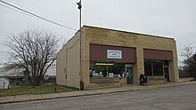
Village office and fire department -
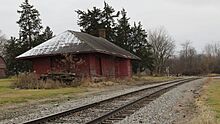
Defunct railroad station in Montgomery

.jpg)

See also
 In Spanish: Montgomery (Míchigan) para niños
