Montclus, Hautes-Alpes facts for kids
Quick facts for kids
Montclus
|
||
|---|---|---|

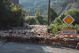
A flock of sheep being herded on the D994 road, at the entrance to Montclus
|
||
|
||
| Country | France | |
| Region | Provence-Alpes-Côte d'Azur | |
| Department | Hautes-Alpes | |
| Arrondissement | Gap | |
| Canton | Serres | |
| Intercommunality | Serres | |
| Area
1
|
21.25 km2 (8.20 sq mi) | |
| Population
(Jan. 2019)
|
52 | |
| • Density | 2.447/km2 (6.34/sq mi) | |
| Time zone | UTC+01:00 (CET) | |
| • Summer (DST) | UTC+02:00 (CEST) | |
| INSEE/Postal code |
05081 /05700
|
|
| Elevation | 680–1,546 m (2,231–5,072 ft) (avg. 719 m or 2,359 ft) |
|
| 1 French Land Register data, which excludes lakes, ponds, glaciers > 1 km2 (0.386 sq mi or 247 acres) and river estuaries. | ||
Montclus is a commune in the Hautes-Alpes department.
Contents
Population
| Historical population | ||
|---|---|---|
| Year | Pop. | ±% |
| 1962 | 22 | — |
| 1968 | 47 | +113.6% |
| 1975 | 40 | −14.9% |
| 1982 | 46 | +15.0% |
| 1990 | 45 | −2.2% |
| 1999 | 48 | +6.7% |
| 2008 | 50 | +4.2% |
Transport
Road
The D450 and D994 roads pass through the commune.
See also
 In Spanish: Montclus (Altos Alpes) para niños

All content from Kiddle encyclopedia articles (including the article images and facts) can be freely used under Attribution-ShareAlike license, unless stated otherwise. Cite this article:
Montclus, Hautes-Alpes Facts for Kids. Kiddle Encyclopedia.


