Monroe Township, Gloucester County, New Jersey facts for kids
Quick facts for kids
Monroe Township, New Jersey
|
||
|---|---|---|
|
Township
|
||

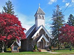
Downer Methodist Episcopal Church in Monroe Township, November 2011
|
||
|
||

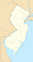
Location of Monroe Township in Gloucester County highlighted in red (right). Inset map: Location of Gloucester County in New Jersey highlighted in red (left).
|
||

Census Bureau map of Monroe Township, Gloucester County, New Jersey
|
||
| Country | ||
| State | ||
| County | ||
| Incorporated | March 3, 1859 | |
| Named for | President James Monroe | |
| Government | ||
| • Type | Faulkner Act (mayor–council) | |
| • Body | Township Council | |
| Area | ||
| • Total | 46.93 sq mi (121.54 km2) | |
| • Land | 46.42 sq mi (120.23 km2) | |
| • Water | 0.51 sq mi (1.31 km2) 1.08% | |
| Area rank | 36th of 565 in state 2nd of 24 in county |
|
| Elevation | 121 ft (37 m) | |
| Population
(2020)
|
||
| • Total | 37,117 | |
| • Estimate
(2023)
|
37,752 | |
| • Rank | 65th of 565 in state 2nd of 24 in county |
|
| • Density | 799.6/sq mi (308.7/km2) | |
| • Density rank | 408th of 565 in state 17th of 24 in county |
|
| Time zone | UTC−05:00 (Eastern (EST)) | |
| • Summer (DST) | UTC−04:00 (Eastern (EDT)) | |
| ZIP Code |
08094 – Williamstown
|
|
| Area code(s) | 609 and 856 | |
| FIPS code | 3401547250 | |
| GNIS feature ID | 0882137 | |
| Website | ||
Monroe Township is a township in Gloucester County, in the U.S. state of New Jersey. As of the 2020 United States census, the township's population was 37,117, its highest decennial count ever and an increase of 988 (+2.7%) from the 36,129 recorded at the 2010 census, which in turn reflected an increase of 7,162 (+24.7%) from the 28,967 counted in the 2000 census. The township is part of the South Jersey region of the state and a suburb of Philadelphia, within the Delaware Valley.
Monroe Township was originally formed as a township by an act of the New Jersey Legislature on March 3, 1859, from portions of Washington Township while the area was still part of Camden County. Monroe Township was shifted to Gloucester County on February 28, 1871, along with the majority of Washington Township. In 1950, portions of the township were transferred to Winslow Township in Camden County. The township was named for President James Monroe.
Contents
Geography
According to the U.S. Census Bureau, the township had a total area of 46.93 square miles (121.54 km2), including 46.42 square miles (120.23 km2) of land and 0.51 square miles (1.31 km2) of water (1.08%).
Victory Lakes (with a 2010 census population of 2,111,) and Williamstown (15,567 residents as of 2010) are unincorporated communities and census-designated places located in Monroe Township.
Other unincorporated communities, localities, and places located partially or completely within the township include Berryland, Broad Lane, Cecil, Cross Keys, Downer, New Brooklyn and Radix.
The township borders the municipalities of Clayton, Franklin Township, Glassboro, and Washington Township in Gloucester County; Buena Vista Township and Folsom in Atlantic County; and Winslow Township in Camden County.
Demographics
| Historical population | |||
|---|---|---|---|
| Census | Pop. | %± | |
| 1860 | 1,417 | — | |
| 1870 | 1,663 | 17.4% | |
| 1880 | 1,858 | 11.7% | |
| 1890 | 1,945 | 4.7% | |
| 1900 | 2,402 | 23.5% | |
| 1910 | 3,015 | 25.5% | |
| 1920 | 3,292 | 9.2% | |
| 1930 | 4,064 | 23.5% | |
| 1940 | 4,310 | 6.1% | |
| 1950 | 5,531 | 28.3% | |
| 1960 | 9,396 | 69.9% | |
| 1970 | 14,071 | 49.8% | |
| 1980 | 21,639 | 53.8% | |
| 1990 | 26,703 | 23.4% | |
| 2000 | 28,967 | 8.5% | |
| 2010 | 36,129 | 24.7% | |
| 2020 | 37,117 | 2.7% | |
| 2023 (est.) | 37,752 | 4.5% | |
| Population sources: 1860–1870 1880–2000 1860–1920 1860–1870 1870 1880–1890 1890–1910 1910–1930 1940–2000 2000 2010 2020 |
|||
2010 census
The 2010 United States census counted 36,129 people, 12,815 households, and 9,445 families in the township. The population density was 778.8 per square mile (300.7/km2). There were 13,387 housing units at an average density of 288.6 per square mile (111.4/km2). The racial makeup was 79.41% (28,689) White, 14.01% (5,060) Black or African American, 0.20% (73) Native American, 2.42% (875) Asian, 0.01% (5) Pacific Islander, 1.54% (557) from other races, and 2.41% (870) from two or more races. Hispanic or Latino of any race were 4.97% (1,795) of the population.
Of the 12,815 households, 34.7% had children under the age of 18; 56.2% were married couples living together; 12.6% had a female householder with no husband present and 26.3% were non-families. Of all households, 21.5% were made up of individuals and 9.7% had someone living alone who was 65 years of age or older. The average household size was 2.80 and the average family size was 3.28.
25.7% of the population were under the age of 18, 7.9% from 18 to 24, 26.0% from 25 to 44, 26.8% from 45 to 64, and 13.6% who were 65 years of age or older. The median age was 38.9 years. For every 100 females, the population had 94.1 males. For every 100 females ages 18 and older there were 90.0 males.
The Census Bureau's 2006–2010 American Community Survey showed that (in 2010 inflation-adjusted dollars) median household income was $66,761 (with a margin of error of +/− $4,083) and the median family income was $83,929 (+/− $4,293). Males had a median income of $61,505 (+/− $3,058) versus $41,946 (+/− $1,826) for females. The per capita income for the borough was $28,270 (+/− $1,121). About 6.1% of families and 7.7% of the population were below the poverty line, including 8.3% of those under age 18 and 10.1% of those age 65 or over.
Sports
Scotland Run Golf Club is a public golf course and country club located in Williamstown. Opened in 1999, the 18-hole course was built on an old sand quarry. The course was named one of the Top 50 Public Courses in the country by the readers of Golf World in their annual Readers' Choice Awards in 2009 and 2010.
Education
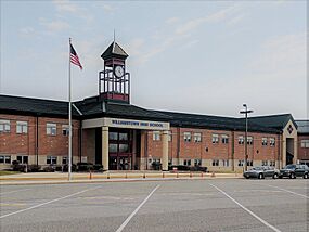
The Monroe Township Public Schools is a comprehensive district serving the educational needs of resident students from pre-kindergarten through twelfth grade. Services are also provided for preschool handicapped students as well as other students with special needs. As of the 2019–20 school year, the district, comprised of six schools, had an enrollment of 5,736 students and 449.2 classroom teachers (on an FTE basis), for a student–teacher ratio of 12.8:1. Schools in the district (with 2019–20 enrollment data from the National Center for Education Statistics) are Holly Glen Elementary School with 437 students in grades K–4, Oak Knoll Elementary School with 529 students in grades K–4, Radix Elementary School with 640 students in grades Pre-K–4, Whitehall Elementary School with 311 students in grades K–4, Williamstown Middle School, with 1,867 students in grades 5–8 and Williamstown High School with 1,837 students in grades 9–12.
Students from across the county are eligible to apply to attend Gloucester County Institute of Technology, a four-year high school in Deptford Township that provides technical and vocational education. As a public school, students do not pay tuition to attend the school.
St. Mary School is a K–8 elementary school that operates under the auspices of the Roman Catholic Diocese of Camden.
Transportation
Roads and highways
As of May 2010[update], the township had a total of 180.28 miles (290.13 km) of roadways, of which 131.72 miles (211.98 km) were maintained by the municipality, 32.30 miles (51.98 km) by Gloucester County and 16.26 miles (26.17 km) by the New Jersey Department of Transportation.
Black Horse Pike is a four-lane, arterial highway which traverses the entire township northwest-to-southeast and provides direct access to downtown Philadelphia (30 minutes) and Atlantic City (35 minutes). The northwestern portion within the township is part of Route 42, while the southeastern segment forms the eastern portion of U.S. Route 322 within the township. The remainder of U.S. Route 322 in Monroe Township is a two-lane arterial highway which traverses the township west of the Black Horse Pike. It provides access to the New Jersey Turnpike, north and south (30 minutes), with access to the Commodore Barry Bridge and Delaware Memorial Bridge to Interstate 95 (40 minutes). Major county roads within the township include County Route 536, County Route 538, and County Route 555.
Running just outside the township is the Atlantic City Expressway, a four-lane, limited access highway that parallels the Black Horse Pike and provides direct access to downtown Atlantic City (30 minutes) and access to the Garden State Parkway, north and south.
Public transportation
NJ Transit bus service is available between Cape May and Philadelphia on the 315 route and between Sicklerville and Philadelphia on the 400 route with local service on the 463 route between Woodbury and Avondale Park and Ride in Sicklerville.
Cross Keys Airport is located in the Cross Keys section.
Points of interest
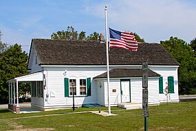
Hall Street School was built in 1887 and was added to the National Register of Historic Places on September 27, 2006.
Notable people
People who were born in, residents of, or otherwise closely associated with Monroe Township include:
- Dave Calloway (born 1968), college basketball coach and the former head men's basketball coach at Monmouth University
- Donovan Ezeiruaku, American football defensive end for the Boston College Eagles
- Cody Miller, politician serving as a member of the New Jersey General Assembly for the 4th legislative district, since taking office on January 9, 2024
- Brittany Ratcliffe (born 1994), soccer player who plays as a forward for Kansas City NWSL in the NWSL


