Mifflintown, Pennsylvania facts for kids
Quick facts for kids
Mifflintown, Pennsylvania
|
|
|---|---|
|
Borough
|
|

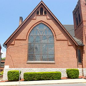
Westminster Presbyterian Church
|
|

Location of Mifflintown in Juniata County, Pennsylvania.
|
|
| Country | United States |
| State | Pennsylvania |
| County | Juniata |
| Settled | 1790 |
| Incorporated | 1833 |
| Area | |
| • Total | 0.14 sq mi (0.36 km2) |
| • Land | 0.14 sq mi (0.36 km2) |
| • Water | 0.00 sq mi (0.00 km2) |
| Elevation
(center of borough)
|
469 ft (143 m) |
| Highest elevation
(northeastn boundary of borough)
|
580 ft (180 m) |
| Lowest elevation
(Juniata River)
|
418 ft (127 m) |
| Population
(2020)
|
|
| • Total | 840 |
| • Density | 6,000.00/sq mi (2,314.87/km2) |
| Time zone | UTC-5 (Eastern (EST)) |
| • Summer (DST) | UTC-4 (EDT) |
| Zip code |
17059
|
| Area code(s) | 717 |
| FIPS code | 42-49304 |
| Website | Mifflintown Borough website |
Mifflintown is a borough in and the county seat of Juniata County, Pennsylvania, United States. The population was 842 at the 2020 census.
Geography
Mifflintown is located at 40°34′15″N 77°23′44″W / 40.57083°N 77.39556°W (40.570728, -77.395488).
According to the United States Census Bureau, the borough has a total area of 0.1 square miles (0.26 km2), all land.
Demographics
| Historical population | |||
|---|---|---|---|
| Census | Pop. | %± | |
| 1850 | 485 | — | |
| 1860 | 767 | 58.1% | |
| 1870 | 857 | 11.7% | |
| 1880 | 842 | −1.8% | |
| 1890 | 877 | 4.2% | |
| 1900 | 953 | 8.7% | |
| 1910 | 954 | 0.1% | |
| 1920 | 1,083 | 13.5% | |
| 1930 | 1,027 | −5.2% | |
| 1940 | 1,097 | 6.8% | |
| 1950 | 1,013 | −7.7% | |
| 1960 | 887 | −12.4% | |
| 1970 | 828 | −6.7% | |
| 1980 | 783 | −5.4% | |
| 1990 | 866 | 10.6% | |
| 2000 | 861 | −0.6% | |
| 2010 | 936 | 8.7% | |
| 2020 | 842 | −10.0% | |
| 2021 (est.) | 831 | −11.2% | |
| Sources: | |||
2020 census
| Race / Ethnicity | Pop 2010 | Pop 2020 | % 2010 | % 2020 |
|---|---|---|---|---|
| White alone (NH) | 748 | 578 | 79.91% | 68.81% |
| Black or African American alone (NH) | 5 | 7 | 0.53% | 0.83% |
| Native American or Alaska Native alone (NH) | 5 | 1 | 0.47% | 0.12% |
| Asian alone (NH) | 4 | 1 | 0.43% | 0.12% |
| Pacific Islander alone (NH) | 0 | 0 | 0.00% | 0.00% |
| Some Other Race alone (NH) | 0 | 2 | 0.00% | 0.24% |
| Mixed Race/Multi-Racial (NH) | 16 | 23 | 1.71% | 2.74% |
| Hispanic or Latino (any race) | 158 | 228 | 16.88% | 27.14% |
| Total | 936 | 840 | 100.00% | 100.00% |
Business
As the county seat of Juniata County, Mifflintown serves as the county's center of business and government. Given the borough's small size, as well as the county's small population, the presence of business and government remain limited. The Mifflintown borough boundaries limit the size of the community, meaning that retail and business functions necessarily spill over onto land of bordering municipalities.
Nevertheless, Mifflintown serves as the corporate headquarters of both the Juniata Valley Bank and Pennian Bank. Empire Kosher Poultry, the nation's largest producer of kosher poultry, has both its headquarters and processing facility in adjoining Fermanagh Township.
Land surrounding Mifflintown serves as Juniata County's retail center as well.
Transportation
Pennsylvania Route 35, a southwest–northeast highway that serves as Juniata County's principal arterial highway running in that direction, forms the main street of Mifflintown. It intersects the former mainline of US routes 22 and 322, which was moved in the early 1970s to a four-lane bypass lying east of the town. The former Pennsylvania Railroad mainline tracks, now owned by the Norfolk Southern Railway, lie across the Juniata River in the adjoining town of Mifflin.
Education
Mifflintown is the home of Juniata High School, which serves the southern half of Juniata County. Tuscarora Junior High School and Juniata Elementary School are also located in the town.
See also
 In Spanish: Mifflintown para niños


