Miami County, Indiana facts for kids
Quick facts for kids
Miami County
|
|
|---|---|

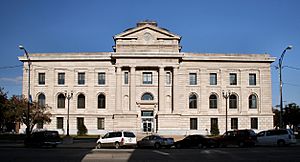
Miami County Courthouse in Peru, Indiana
|
|

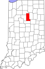
Location within the U.S. state of Indiana
|
|
 Indiana's location within the U.S. |
|
| Country | |
| State | |
| Founded | January 30, 1833 |
| Named for | Miami tribe |
| Seat | Peru |
| Largest city | Peru |
| Area | |
| • Total | 377.39 sq mi (977.4 km2) |
| • Land | 373.84 sq mi (968.2 km2) |
| • Water | 3.55 sq mi (9.2 km2) 0.94%% |
| Population
(2020)
|
|
| • Total | 35,962 |
| • Estimate
(2023)
|
35,402 |
| • Density | 95.2913/sq mi (36.7922/km2) |
| Time zone | UTC−5 (Eastern) |
| • Summer (DST) | UTC−4 (EDT) |
| Congressional district | 2nd |
| Indiana county number 52 | |
Miami County is a county located in the U.S. state of Indiana. As of 2020, the population was 35,962. The county seat is the City of Peru. Miami County is part of the Kokomo-Peru CSA.
Contents
History
Indiana became a state on December 11, 1816, after being Indiana Territory for sixteen years. Originally, Indiana was part of the Northwest Territory, which was made up of land gained by the British after the French and Indian War and organized into a territory after the American Revolution. It was after the revolution that settlement in the area by Europeans really began. Knox territory was created in 1790 and included all of present-day Indiana and areas of Illinois. Ancestry's Red Book notes that jurisdiction in Knox territory changed due to Indian uprisings in the area from 1790 to 1810. In 1800, Indiana became the name of a territory. Parts of Michigan and Illinois both broke away from the territory before it became a state in 1816.
Miami County was formed in 1832 from Cass County and unorganized land. It was named for the Miami, a Native American people, many of whom still live in this area. In 1834, Miami County widened its western border taking some area from Cass County. In 1838 a small portion of unorganized territory was added to the northeastern border, but in 1844 that area was lost to Fulton County. Miami County has been its present shape since 1844.
Geography
According to the 2010 census, the county has a total area of 377.39 square miles (977.4 km2), of which 373.84 square miles (968.2 km2) (or 99.06%) is land and 3.55 square miles (9.2 km2) (or 0.94%) is water.
Adjacent counties
- Fulton County (north)
- Wabash County (east)
- Grant County (southeast)
- Howard County (south)
- Cass County (west)
Major highways
Communities
City
Towns
Census-designated places
- Grissom AFB
- Mexico
Other unincorporated places
- Bennetts Switch
- Birmingham
- Chili
- Courter
- Deedsville
- Doyle
- Erie
- Flora
- Gilead
- Loree
- McGrawsville
- Miami
- Nead
- New Santa Fe
- North Grove
- Oakdale
- Oakley
- Park View Heights
- Peoria
- Perrysburg
- Pettysville
- Santa Fe
- South Peru
- Stockdale
- Wawpecong
- Wells
Extinct
Townships
- Allen Township
- Butler Township
- Clay Township
- Deer Creek Township
- Erie Township
- Harrison Township
- Jackson Township
- Jefferson Township
- Perry Township
- Peru Township
- Pipe Creek Township
- Richland Township
- Union Township
- Washington Township
Climate and weather
| Weather chart for Peru, Indiana | |||||||||||||||||||||||||||||||||||||||||||||||
|---|---|---|---|---|---|---|---|---|---|---|---|---|---|---|---|---|---|---|---|---|---|---|---|---|---|---|---|---|---|---|---|---|---|---|---|---|---|---|---|---|---|---|---|---|---|---|---|
| J | F | M | A | M | J | J | A | S | O | N | D | ||||||||||||||||||||||||||||||||||||
|
2.2
31
14
|
1.9
36
17
|
2.7
47
27
|
3.5
60
37
|
4.1
71
48
|
4.2
80
58
|
4.1
83
61
|
4
81
59
|
3.2
75
51
|
2.8
63
40
|
3.1
49
31
|
2.7
36
20
|
||||||||||||||||||||||||||||||||||||
| temperatures in °F precipitation totals in inches source: The Weather Channel |
|||||||||||||||||||||||||||||||||||||||||||||||
|
Metric conversion
|
|||||||||||||||||||||||||||||||||||||||||||||||
In recent years, average temperatures in Peru have ranged from a low of 14 °F (−10 °C) in January to a high of 83 °F (28 °C) in July, although a record low of −24 °F (−31 °C) was recorded in January 1985 and a record high of 103 °F (39 °C) was recorded in June 1988. Average monthly precipitation ranged from 1.89 inches (48 mm) in February to 4.23 inches (107 mm) in June.
Demographics
| Historical population | |||
|---|---|---|---|
| Census | Pop. | %± | |
| 1840 | 3,048 | — | |
| 1850 | 11,304 | 270.9% | |
| 1860 | 16,851 | 49.1% | |
| 1870 | 21,052 | 24.9% | |
| 1880 | 24,083 | 14.4% | |
| 1890 | 25,823 | 7.2% | |
| 1900 | 28,344 | 9.8% | |
| 1910 | 29,350 | 3.5% | |
| 1920 | 28,668 | −2.3% | |
| 1930 | 29,032 | 1.3% | |
| 1940 | 27,926 | −3.8% | |
| 1950 | 28,201 | 1.0% | |
| 1960 | 38,000 | 34.7% | |
| 1970 | 39,246 | 3.3% | |
| 1980 | 39,820 | 1.5% | |
| 1990 | 36,897 | −7.3% | |
| 2000 | 36,082 | −2.2% | |
| 2010 | 36,903 | 2.3% | |
| 2020 | 35,962 | −2.5% | |
| 2023 (est.) | 35,402 | −4.1% | |
| U.S. Decennial Census 1790-1960 1900-1990 1990-2000 2010-2013 |
|||
As of the 2010 United States Census, there were 36,903 people, 13,456 households, and 9,330 families residing in the county. The population density was 98.7 inhabitants per square mile (38.1/km2). There were 15,479 housing units at an average density of 41.4 per square mile (16.0/km2). The racial makeup of the county was 91.8% white, 4.5% black or African American, 0.9% American Indian, 0.3% Asian, 0.6% from other races, and 1.8% from two or more races. Those of Hispanic or Latino origin made up 2.5% of the population. In terms of ancestry, 27.2% were German, 17.3% were American, 12.0% were Irish, and 8.4% were English.
Of the 13,456 households, 32.5% had children under the age of 18 living with them, 53.2% were married couples living together, 11.3% had a female householder with no husband present, 30.7% were non-families, and 26.2% of all households were made up of individuals. The average household size was 2.49 and the average family size was 2.97. The median age was 39.5 years.
The median income for a household in the county was $47,697 and the median income for a family was $49,282. Males had a median income of $40,038 versus $26,011 for females. The per capita income for the county was $18,854. About 13.0% of families and 16.7% of the population were below the poverty line, including 26.6% of those under age 18 and 8.9% of those age 65 or over.
Major employers of Miami County include:
Ferrellgas (Peru )
Schneider Electric Square D (Peru )
Miami Correctional Facility (Bunker Hill )
Indiana Correction Dept (Bunker Hill )
Armour-Eckrich Meats (Peru )
American Stationery Co (Peru ) http://www.americanstationery.com
Dukes Memorial Hospital (Peru ) http://www.dukesmemorialhosp.com
Miami County (Peru )
Bryan Steam LLC (Peru ) http://www.bryanboilers.com
Snavely Machine & Mfg Co Inc (Peru )
See also
 In Spanish: Condado de Miami (Indiana) para niños

