Meauwataka, Michigan facts for kids
Quick facts for kids
Meauwataka, Michigan
|
|
|---|---|

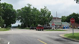
Intersection of N. 29 Road and E. 24 Road in Meauwataka
|
|
| Country | |
| State | |
| County | Wexford |
| Township | Colfax |
| Settled | 1867 |
| Elevation | 1,368 ft (417 m) |
| Time zone | UTC-5 (Eastern (EST)) |
| • Summer (DST) | UTC-4 (EDT) |
| ZIP code(s) |
49601 (Cadillac)
|
| Area code(s) | 231 |
| GNIS feature ID | 632062 |
Meauwataka (/miːəwətɑːkə/ mee-Ə-wə-TAH-kə) is an unincorporated community in U.S. state of Michigan. Located in Colfax Township, Wexford County, Meauwataka is part of Northern Michigan, and is located within the Cadillac micropolitan area. As an unincorporated community, Meauwataka has no legally defined boundaries or population statistics of its own.
History
Meauwataka takes its name from a Potawatomi word meaning "halfway", as the community is located roughly halfway between Lake Mitchell and the Manistee River. The community was settled in 1867, and was first known as Dayhuff Lake, after a nearby lake. A post office under the name 'Meauwataka' opened in 1872, lasting until 1952.

All content from Kiddle encyclopedia articles (including the article images and facts) can be freely used under Attribution-ShareAlike license, unless stated otherwise. Cite this article:
Meauwataka, Michigan Facts for Kids. Kiddle Encyclopedia.


