Mazama Glacier (Mount Adams) facts for kids
Quick facts for kids Mazama Glacier |
|
|---|---|

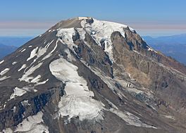
Mazama Glacier at lower center of image
|
|
| Type | Mountain glacier |
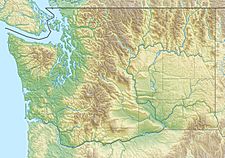
| Coordinates | 46°10′49″N 121°28′12″W / 46.18028°N 121.47000°W |
| Area | 1.40 km2 (0.54 sq mi) in 2006 |
| Length | 1.10 mi (1.77 km) |
| Terminus | Talus |
| Status | Retreating |
Mazama Glacier is located on the southeast slopes of Mount Adams a stratovolcano in the U.S. state of Washington. Mazama Glacier is in the Yakama Indian Reservation. The glacier descends from approximately 10,800 ft (3,300 m) to a terminus near 7,600 ft (2,300 m). Mazama Glacier has been in a general state of retreat for over 100 years and lost 46 percent of its surface area between 1904 and 2006.
Originally known as Hell-roaring Glacier, the name was changed in 1895 by a group from the Mazamas club while they were on their second annual outing.

All content from Kiddle encyclopedia articles (including the article images and facts) can be freely used under Attribution-ShareAlike license, unless stated otherwise. Cite this article:
Mazama Glacier (Mount Adams) Facts for Kids. Kiddle Encyclopedia.


