Mason Jewett Field Airport facts for kids
Quick facts for kids
Mason Jewett Field Airport
|
|||||||||||
|---|---|---|---|---|---|---|---|---|---|---|---|
 |
|||||||||||
| Summary | |||||||||||
| Airport type | Public | ||||||||||
| Owner/Operator | Capital Region Airport Authority | ||||||||||
| Serves | Mason, Michigan | ||||||||||
| Elevation AMSL | 920 ft / 280 m | ||||||||||
| Coordinates | 42°33′57″N 084°25′24″W / 42.56583°N 84.42333°W | ||||||||||
| Website | www.flylansing.com/... | ||||||||||
| Runway | |||||||||||
|
|||||||||||
| Statistics (2009) | |||||||||||
|
|||||||||||
|
Source: Federal Aviation Administration
|
|||||||||||
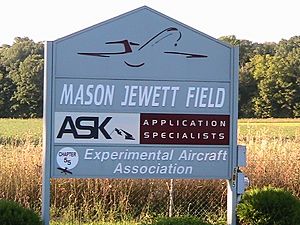
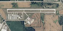
Mason Jewett Field (ICAO: KTEW, FAA LID: TEW) is a public airport in the U.S. state of Michigan. It is one mile (1.85 km) southeast of Mason, in Ingham County. The airport is owned and operated by the Capital Region Airport Authority. The airport covers 275 acres (111 ha). The elevation is 920 feet (280 m) above sea level. The airport has one asphalt runway. There is no scheduled commercial airline service.
History
On December 16, 1943, Arthur Jewett bought 180 acres (73 ha) of land for the airport. In 1944, the runway was built. In 1949 lights were installed on the runway. In March 1977, the Capital Region Airport Authority purchased the airport from Arthur Jewett.
Related pages
- Bibliography
- Smith, Bartlett. Mason Jewett Airport , Experimental Aircraft Association Chapter 55 Wingtips, eaa55.org, March 2001, retrieved 2010-Apr-22
Black History Month on Kiddle
Famous African-American Inventors:
 | George Robert Carruthers |
 | Patricia Bath |
 | Jan Ernst Matzeliger |
 | Alexander Miles |

All content from Kiddle encyclopedia articles (including the article images and facts) can be freely used under Attribution-ShareAlike license, unless stated otherwise. Cite this article:
Mason Jewett Field Airport Facts for Kids. Kiddle Encyclopedia.

