Maple Shade Township, New Jersey facts for kids
Quick facts for kids
Maple Shade Township, New Jersey
|
||
|---|---|---|
|
Township
|
||

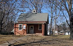
Chesterfield School
|
||
|
||
| Motto(s):
"Nice Town, Friendly People"
|
||

Maple Shade highlighted in Burlington County. Inset: Burlington County highlighted in the State of New Jersey.
|
||

Census Bureau map of Maple Shade Township, New Jersey
|
||
| Country | ||
| State | ||
| County | ||
| Established | November 6, 1688 as Chester Township | |
| Incorporated | February 21, 1798 | |
| Renamed | November 6, 1945 as Maple Shade Township | |
| Government | ||
| • Type | Faulkner Act (council–manager) | |
| • Body | Township Council | |
| Area | ||
| • Total | 3.83 sq mi (9.92 km2) | |
| • Land | 3.83 sq mi (9.91 km2) | |
| • Water | <0.01 sq mi (<0.01 km2) 0.03% | |
| Area rank | 303rd of 565 in state 27th of 40 in county |
|
| Elevation | 46 ft (14 m) | |
| Population
(2020)
|
||
| • Total | 19,980 | |
| • Estimate
(2023)
|
20,088 | |
| • Rank | 139th of 565 in state 8th of 40 in county |
|
| • Density | 5,220.8/sq mi (2,015.8/km2) | |
| • Density rank | 108th of 565 in state 2nd of 40 in county |
|
| Time zone | UTC−05:00 (Eastern (EST)) | |
| • Summer (DST) | UTC−04:00 (Eastern (EDT)) | |
| ZIP Code |
08052
|
|
| Area code(s) | 856 | |
| FIPS code | 3400543740 | |
| GNIS feature ID | 0882094 | |
Maple Shade Township is a township in Burlington County, in the U.S. state of New Jersey. As of the 2020 United States census, the township's population was 19,980, an increase of 849 (+4.4%) from the 2010 census count of 19,131, which in turn reflected an increase of 0.3% from the 19,079 counted in the 2000 census. The township, and all of Burlington County, is a part of the Philadelphia-Reading-Camden combined statistical area and the Delaware Valley.
What is now Maple Shade was originally formed as Chester Township on November 6, 1688, and was known as Cropwell Township from June 5, 1690, through February 22, 1699. Chester was incorporated as one of New Jersey's initial 104 townships by an act of the New Jersey Legislature on February 21, 1798. Portions of the township were taken to form Cinnaminson Township (March 15, 1860) and Moorestown Township (March 11, 1922). The municipality's name was changed to Maple Shade Township as of November 6, 1945, based on the results of a referendum passed that same day.
Contents
Geography
According to the United States Census Bureau, the township had a total area of 3.83 square miles (9.92 km2), including 3.83 square miles (9.91 km2) of land and <0.01 square miles (<0.01 km2) of water (0.03%).
The township borders Cinnaminson Township, Moorestown Township and Mount Laurel Township in Burlington County; and Cherry Hill and Pennsauken Township in Camden County.
Climate
The climate in this area is characterized by hot, humid summers and generally mild to cool winters. According to the Köppen Climate Classification system, Maple Shade Township has a humid subtropical climate, abbreviated "Cfa" on climate maps, with the coldest months of January and February averaging about 33 °F (0.6 °C), and with an annual average temperature of 54 °F (12 °C).
Demographics
| Historical population | |||
|---|---|---|---|
| Census | Pop. | %± | |
| 1800 | 1,464 | — | |
| 1810 | 1,839 | 25.6% | |
| 1820 | 2,253 | 22.5% | |
| 1830 | 2,333 | 3.6% | |
| 1840 | 2,603 | 11.6% | |
| 1850 | 3,601 | 38.3% | |
| 1860 | 2,227 | * | −38.2% |
| 1870 | 2,586 | 16.1% | |
| 1880 | 2,855 | 10.4% | |
| 1890 | 3,768 | 32.0% | |
| 1900 | 4,420 | 17.3% | |
| 1910 | 5,069 | 14.7% | |
| 1920 | 7,273 | 43.5% | |
| 1930 | 5,117 | * | −29.6% |
| 1940 | 5,535 | 8.2% | |
| 1950 | 6,560 | 18.5% | |
| 1960 | 12,947 | 97.4% | |
| 1970 | 16,464 | 27.2% | |
| 1980 | 20,525 | 24.7% | |
| 1990 | 19,211 | −6.4% | |
| 2000 | 19,079 | −0.7% | |
| 2010 | 19,131 | 0.3% | |
| 2020 | 19,980 | 4.4% | |
| 2023 (est.) | 20,088 | 5.0% | |
| Population sources: 1800–2000 1800–1920 1840 1850–1870 1850 1870 1880–1890 1890–1910 1910–1930 1940–2000 2000 2010 2020 * = Lost territory in previous decade. |
|||
2010 census
The 2010 United States census counted 19,131 people, 8,525 households, and 4,655 families in the township. The population density was 5,006.1 per square mile (1,932.9/km2). There were 9,186 housing units at an average density of 2,403.7 per square mile (928.1/km2). The racial makeup was 78.62% (15,040) White, 9.54% (1,826) Black or African American, 0.16% (31) Native American, 5.65% (1,080) Asian, 0.03% (5) Pacific Islander, 3.14% (601) from other races, and 2.86% (548) from two or more races. Hispanic or Latino of any race were 8.32% (1,591) of the population.
Of the 8,525 households, 22.8% had children under the age of 18; 37.9% were married couples living together; 11.8% had a female householder with no husband present and 45.4% were non-families. Of all households, 36.5% were made up of individuals and 10.4% had someone living alone who was 65 years of age or older. The average household size was 2.21 and the average family size was 2.94.
18.4% of the population were under the age of 18, 9.8% from 18 to 24, 31.9% from 25 to 44, 26.6% from 45 to 64, and 13.2% who were 65 years of age or older. The median age was 37.6 years. For every 100 females, the population had 94.6 males. For every 100 females ages 18 and older there were 93.2 males.
The Census Bureau's 2015–2019 American Community Survey showed that (in 2019 inflation-adjusted dollars) median household income was $61,335 (with a margin of error of +/− $3,606) and the median family income was $825854 (+/− $7,763). Males had a median income of $58,963 (+/− $4,320) versus $49,215 (+/− $2.945) for females. The per capita income for the borough was $34,774 (+/− $2,053). About 8.1% of families and 9.1% of the population were below the poverty line, including 13.2% of those under age 18 and 4.6% of those age 65 or over.
Education
The Maple Shade School District serves public school students in pre-kindergarten through twelfth grade. As of the 2021–22 school year, the district, comprised of four schools, had an enrollment of 2,370 students and 219.0 classroom teachers (on an FTE basis), for a student–teacher ratio of 10.8:1. Schools in the district (with 2021–22 enrollment data from the National Center for Education Statistics) are Howard R. Yocum Elementary School with 565 students in grades PreK to 1 Maude M. Wilkins Elementary School with 534 students in grades 2-4 Ralph J. Steinhauer Elementary School with 342 students in grades 5-6 and Maple Shade High School with 888 students in grades 7-12.
Students from Maple Shade Township, and from all of Burlington County, are eligible to attend the Burlington County Institute of Technology, a countywide public school district that serves the vocational and technical education needs of students at the high school and post-secondary level at its campuses in Medford and Westampton Township.
Transportation
Roads and highways
As of May 2010[update], the township had a total of 51.98 miles (83.65 km) of roadways, of which 42.65 miles (68.64 km) were maintained by the municipality, 3.38 miles (5.44 km) by Burlington County and 5.95 miles (9.58 km) by the New Jersey Department of Transportation.
Passing through the township are Route 38, Route 41 and Route 73. The New Jersey Turnpike and Interstate 295 are both accessible just outside the township by way of Route 73.
Public transportation
NJ Transit provides bus service to and from Philadelphia on route 317 (from Asbury Park), and 407 (from Moorestown Mall) to Camden, and on the 413 route between Camden, and Burlington.
Notable people
People who were born in, residents of, or otherwise closely associated with Maple Shade Township include:
- George H. Barbour (1917–1992), lawyer and politician who served in the New Jersey General Assembly for one term in the 1960s and two terms in the 1970s, where he represented the 7th Legislative District
- Paul Baloche (born 1962), Christian music artist, worship leader and singer-songwriter
- Randy Cain (1945–2009), Philadelphia soul singer with The Delfonics
- Billy Darnell (1926–2007), professional wrestler and major star of the 1940s and 1950s who won championships in the National Wrestling Alliance and World Wide Wrestling Federation
- John G. Morris (1916–2017), picture editor, author and journalist, and an important figure in the history of photojournalism
- Suzanne Muldowney (born 1952), performance artist best known for her appearances on The Howard Stern Show to discuss and perform her dance interpretation of the cartoon character Underdog
- Daniel Nester (born 1968), writer, editor and poet
- John Tartaglia (born 1978), puppeteer, actor, singer, dancer, voice artist and comedian
- George E. Williams, politician who served in the New Jersey General Assembly from the 7th Legislative District from 1994 to 1996.
See also
 In Spanish: Municipio de Maple Shade para niños


