
Map coloring facts for kids

Colors are used to show the altitude, on Easter Island

Map of the United States. Colors are used to show the different states.

Map coloring is a term used for two different concepts: In geography and mapmaking it is used to say that colors are assigned to certain areas on a map. Examples of this are coloring that show the countries or divisions of a country, but also to visualize other data, for example the altitude. The other use is in mathematics: There it is used to describe the problem of finding the minimal number of colors needed to color a given map.
Related pages
Images for kids
-
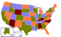
A map of the United States using colors to show political divisions using the four color theorem.


All content from Kiddle encyclopedia articles (including the article images and facts) can be freely used under Attribution-ShareAlike license, unless stated otherwise. Cite this article:
Map coloring Facts for Kids. Kiddle Encyclopedia.