Mangawhero River facts for kids
Quick facts for kids Mangawhero River |
|
|---|---|

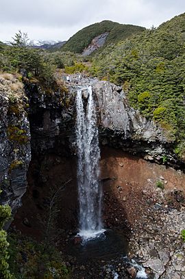
The Mangawhero Falls on the Mangawhero River
|
|
| Native name | Mangawhero |
| Country | New Zealand |
| Region | Manawatū-Whanganui |
| Towns | Ohakune |
| Physical characteristics | |
| Main source | Mount Ruapehu Tūroa skifield 1,800 m (5,900 ft) 39°18′4″S 175°32′13″E / 39.30111°S 175.53694°E |
| River mouth | Whangaehu River 7 km (4.3 mi) south-west of Mangamahu 50 m (160 ft) 39°51′30″S 175°17′55″E / 39.85833°S 175.29861°E |
| Length | 130 kilometres (81 mi) |
| Basin features | |
| Progression | Mangawhero River → Whangaehu River |
| River system | Whangaehu River |
| Tributaries |
|
| Waterfalls | Mangawhero Falls, Raukawa Falls |
The Mangawhero River is in the North Island of New Zealand.
It drains the south-western slopes of Mount Ruapehu, passes through Ohakune before discharging into the Whangaehu River to the south-west of Mangamahu.
On 8 September 1979 up to 17,000 litres (4,500 US gal) of heating oil were split into the river from the Turoa ski field.
The name Mangawhero means comes from the Maori word manga meaning "stream" and whero meaning "red".

All content from Kiddle encyclopedia articles (including the article images and facts) can be freely used under Attribution-ShareAlike license, unless stated otherwise. Cite this article:
Mangawhero River Facts for Kids. Kiddle Encyclopedia.

