Malabar, Florida facts for kids
Quick facts for kids
Malabar, Florida
|
||
|---|---|---|
| Town of Malabar | ||
|
||

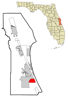
Location in Brevard County and the state of Florida
|
||
| Country | United States | |
| State | Florida | |
| County | Brevard | |
| Incorporated | 1962 | |
| Government | ||
| • Type | Mayor–Council | |
| Area | ||
| • Total | 13.27 sq mi (34.36 km2) | |
| • Land | 10.69 sq mi (27.70 km2) | |
| • Water | 2.57 sq mi (6.66 km2) | |
| Elevation | 23 ft (7 m) | |
| Population
(2020)
|
||
| • Total | 2,949 | |
| • Density | 275.76/sq mi (106.47/km2) | |
| Time zone | UTC-5 (Eastern (EST)) | |
| • Summer (DST) | UTC-4 (EDT) | |
| ZIP code |
32950
|
|
| Area code(s) | 321 | |
| FIPS code | 12-42625 | |
| GNIS feature ID | 0286324 | |
Malabar is a town in Brevard County, Florida. It is part of the Palm Bay–Melbourne–Titusville, Florida Metropolitan Statistical Area. The population was 2,949 at the 2020 United States Census, up from 2,757 at the 2010 census.
Contents
Geography
Malabar is located at 27°59′39″N 80°34′53″W / 27.994286°N 80.581266°W.
According to the United States Census Bureau, the town has a total area of 13.2 square miles (34 km2). 10.6 square miles (27 km2) of it is land and 2.6 square miles (6.7 km2) of it (19.53%) is water.
Climate
The climate for the Town of Malabar is characterized by hot, humid summers and generally mild to cool winters. According to the Köppen Climate Classification system, Malabar has a humid subtropical climate zone, abbreviated "Cfa" on climate maps.
| Climate data for Malabar, FL | |||||||||||||
|---|---|---|---|---|---|---|---|---|---|---|---|---|---|
| Month | Jan | Feb | Mar | Apr | May | Jun | Jul | Aug | Sep | Oct | Nov | Dec | Year |
| Record high °F (°C) | 89 (32) |
91 (33) |
93 (34) |
97 (36) |
99 (37) |
101 (38) |
102 (39) |
101 (38) |
98 (37) |
96 (36) |
91 (33) |
93 (34) |
102 (39) |
| Mean daily maximum °F (°C) | 71 (22) |
74 (23) |
77 (25) |
81 (27) |
86 (30) |
89 (32) |
91 (33) |
91 (33) |
88 (31) |
84 (29) |
79 (26) |
73 (23) |
82 (28) |
| Mean daily minimum °F (°C) | 49 (9) |
52 (11) |
55 (13) |
60 (16) |
67 (19) |
72 (22) |
73 (23) |
73 (23) |
73 (23) |
68 (20) |
60 (16) |
53 (12) |
63 (17) |
| Record low °F (°C) | 17 (−8) |
27 (−3) |
25 (−4) |
35 (2) |
47 (8) |
55 (13) |
60 (16) |
60 (16) |
57 (14) |
41 (5) |
30 (−1) |
21 (−6) |
17 (−8) |
| Average precipitation inches (mm) | 2.27 (58) |
2.63 (67) |
3.28 (83) |
2.13 (54) |
3.29 (84) |
6.71 (170) |
5.96 (151) |
7.68 (195) |
7.64 (194) |
5.06 (129) |
2.88 (73) |
2.57 (65) |
52.10 (1,323) |
Demographics
| Historical population | |||
|---|---|---|---|
| Census | Pop. | %± | |
| 1970 | 634 | — | |
| 1980 | 1,118 | 76.3% | |
| 1990 | 1,977 | 76.8% | |
| 2000 | 2,622 | 32.6% | |
| 2010 | 2,757 | 5.1% | |
| 2020 | 2,949 | 7.0% | |
| U.S. Decennial Census | |||
2010 and 2020 census
| Race | Pop 2010 | Pop 2020 | % 2010 | % 2020 |
|---|---|---|---|---|
| White (NH) | 2,453 | 2,382 | 88.97% | 80.77% |
| Black or African American (NH) | 97 | 106 | 3.52% | 3.59% |
| Native American or Alaska Native (NH) | 13 | 4 | 0.47% | 0.14% |
| Asian (NH) | 25 | 60 | 0.91% | 2.03% |
| Pacific Islander or Native Hawaiian (NH) | 1 | 3 | 0.04% | 0.10% |
| Some other race (NH) | 0 | 15 | 0.00% | 0.51% |
| Two or more races/Multiracial (NH) | 54 | 176 | 1.96% | 5.97% |
| Hispanic or Latino (any race) | 114 | 203 | 4.13% | 6.88% |
| Total | 2,757 | 2,949 |
As of the 2020 United States census, there were 2,949 people, 1,380 households, and 947 families residing in the town.
As of the 2010 United States census, there were 2,757 people, 949 households, and 766 families residing in the town.
Main roads
Malabar Road (Florida State Road 514)
This route is the way to go to Palm Bay and surrounding.
Weber Road
This route is the way to go to Grant-Valkaria, Florida.
Corey Road
This is another route to go to Grant-Valkaria, Florida.
Atz Road
This road connects from west of Weber Road through Corey Road and on to LaCourt Lane.
Hall Road
This road connects from west of Weber Road through Corey Road and on to Marie Street.
See also
 In Spanish: Malabar (Florida) para niños


