Mahnomen County, Minnesota facts for kids
Quick facts for kids
Mahnomen County
|
|
|---|---|

|
|

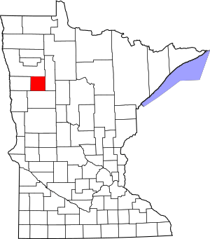
Location within the U.S. state of Minnesota
|
|
 Minnesota's location within the U.S. |
|
| Country | |
| State | |
| Founded | December 27, 1906 |
| Named for | Ojibway word for wild rice |
| Seat | Mahnomen |
| Largest city | Mahnomen |
| Area | |
| • Total | 583 sq mi (1,510 km2) |
| • Land | 558 sq mi (1,450 km2) |
| • Water | 25 sq mi (60 km2) 4.3%% |
| Population
(2020)
|
|
| • Total | 5,411 |
| • Estimate
(2023)
|
5,280 |
| • Density | 9.7/sq mi (3.7/km2) |
| Time zone | UTC−6 (Central) |
| • Summer (DST) | UTC−5 (CDT) |
| Congressional district | 7th |
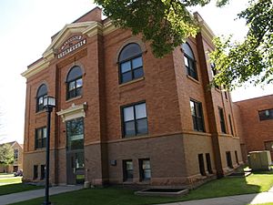
Mahnomen County (/məˈnoʊmən/ mə-NOH-mən) is a county in the U.S. state of Minnesota. As of the 2020 census, the population was 5,411. Its county seat is Mahnomen.
The county is part of the White Earth Indian Reservation. It is the only county in Minnesota entirely within an Indian reservation. Mahnomen, East Polk, and Becker counties constitute one of northwestern Minnesota's biggest cattle-raising areas.
Contents
History
The county was created from the east half of Norman County on December 27, 1906, with Mahnomen, a former railway station town, as the county seat. The county was named for the town, the name of which is one spelling of the Ojibwe word for "wild rice".
From 1857 to 1858, similarly named Manomin County existed in Minnesota, which merged into Anoka County.
Geography
The Wild Rice River enters the county from Clearwater County and flows west through the central part of the county. The White Earth River originates from White Earth Lake on the county's southern border and flows northwest to its confluence with the Wild Rice near Mahnomen. The county terrain consists of low rolling hills, carved with drainages. The eastern part of the county is dotted with lakes and ponds and largely wooded. All non-wooded areas are devoted to agriculture where possible. The county slopes to the west and north, with its highest point near the middle of the east border, at 1,825 ft (556 m) ASL. The county has an area of 583 square miles (1,510 km2), of which 558 square miles (1,450 km2) is land and 25 square miles (65 km2) (4.3%) is water. Mahnomen is one of 17 Minnesota savanna region counties with more savanna soils than either prairie or forest soils.
Major highways
Airports
- Mahnomen County Airport (3N8) - south of Mahnomen
Adjacent counties
- Polk County - north
- Clearwater County - east
- Becker County - south
- Norman County - west
Protected areas
Source:
- Beaulife State Wildlife Management Area
- Bejou State Wildlife Management Area
- Budde Meadow State Wildlife Management Area
- Dittmer State Wildlife Management Area
- Foot State Wildlife Management Area
- Hasselton State Wildlife Management Area (part)
- Loncrace State Wildlife Management Area
- Mahgre State Wildlife Management Area
- Rush Lake State Wildlife Management Area
- Santee Prairie Scientific and Natural Area
- Wambach State Wildlife Management Area
- Warren Lake State Wildlife Management Area
Demographics
| Historical population | |||
|---|---|---|---|
| Census | Pop. | %± | |
| 1910 | 3,249 | — | |
| 1920 | 6,197 | 90.7% | |
| 1930 | 6,153 | −0.7% | |
| 1940 | 8,054 | 30.9% | |
| 1950 | 7,059 | −12.4% | |
| 1960 | 6,341 | −10.2% | |
| 1970 | 5,638 | −11.1% | |
| 1980 | 5,535 | −1.8% | |
| 1990 | 5,044 | −8.9% | |
| 2000 | 5,190 | 2.9% | |
| 2010 | 5,413 | 4.3% | |
| 2020 | 5,411 | 0.0% | |
| 2023 (est.) | 5,280 | −2.5% | |
| U.S. Decennial Census 1790-1960 1900-1990 1990-2000 2010-2020 |
|||
2020 Census
| Race | Num. | Perc. |
|---|---|---|
| White (NH) | 2,278 | 42.1% |
| Black or African American (NH) | 8 | 0.1% |
| Native American (NH) | 2,256 | 41.7% |
| Asian (NH) | 7 | 0.13% |
| Pacific Islander (NH) | 0 | 0.% |
| Other/Mixed (NH) | 708 | 13.1% |
| Hispanic or Latino | 154 | 2.84% |
Communities
Cities
Census-designated places
- Beaulieu
- Midway
- Naytahwaush
- Pine Bend
- Riverland
- Roy Lake
- The Ranch
- Twin Lakes
- West Roy Lake
Unincorporated community
Townships
- Beaulieu Township
- Bejou Township
- Chief Township
- Clover Township
- Gregory Township
- Heier Township
- Island Lake Township
- La Garde Township
- Lake Grove Township
- Little Elbow Township
- Marsh Creek Township
- Oakland Township
- Pembina Township
- Popple Grove Township
- Rosedale Township
- Twin Lakes Township
See also
 In Spanish: Condado de Mahnomen para niños

