Macy, Nebraska facts for kids
Quick facts for kids
Macy, Nebraska
|
|
|---|---|

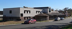
Omaha Nation Public School in Macy,
October 2010 |
|

Location of Macy, Nebraska
|
|
| Country | United States |
| State | Nebraska |
| County | Thurston |
| Area | |
| • Total | 1.59 sq mi (4.13 km2) |
| • Land | 1.59 sq mi (4.13 km2) |
| • Water | 0.00 sq mi (0.00 km2) |
| Elevation | 1,188 ft (362 m) |
| Population
(2020)
|
|
| • Total | 1,045 |
| • Density | 655.17/sq mi (252.91/km2) |
| Time zone | UTC-6 (Central (CST)) |
| • Summer (DST) | UTC-5 (CDT) |
| ZIP code |
68039
|
| Area code(s) | 402 |
| FIPS code | 31-30170 |
| GNIS feature ID | 2393115 |
Macy is a census-designated place (CDP) in Thurston County, Nebraska, United States. The population was 1,045 at the 2020 census. It is within the Omaha Reservation, and includes Omaha Nation Public Schools.
History
The first post office at Macy was established in 1906. Macy was named from a compound of the words Omaha and Agency.
Geography
According to the United States Census Bureau, the CDP has a total area of 1.6 square miles (4.1 km2), all land.
Demographics
| Historical population | |||
|---|---|---|---|
| Census | Pop. | %± | |
| 2020 | 1,045 | — | |
| U.S. Decennial Census | |||
2020 census
As of the census of 2020, the population was 1,045. The population density was 655.2 inhabitants per square mile (253.0/km2). There were 229 housing units at an average density of 143.6 per square mile (55.4/km2). The racial makeup of the cdp was 98.1% Native American, 0.7% White, 0.1% Asian, 0.5% from other races, and 0.7% from two or more races. Ethnically, the population was 0.9% Hispanic or Latino of any race.
Notable people
- Rodney A. Grant, actor born in Macy
- Tuffy Griffiths, boxer
- Susan La Flesche Picotte, first Native American woman physician
See also
 In Spanish: Macy (Nebraska) para niños

