M'Sila Province facts for kids
Quick facts for kids
M'Sila Province
ولاية المسيلة
|
|
|---|---|

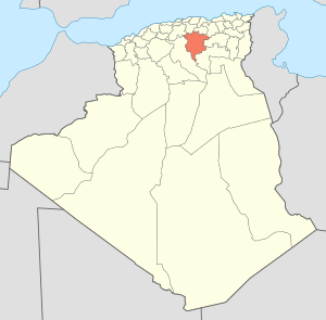
Map of Algeria highlighting M'Sila
|
|
| Country | |
| Capital | M'Sila |
| Area | |
| • Total | 18,718 km2 (7,227 sq mi) |
| Population
(2008)
|
|
| • Total | 991,846 |
| • Density | 52.9889/km2 (137.241/sq mi) |
| Time zone | UTC+01 (CET) |
| Area Code | +213 (0) 35 |
| ISO 3166 code | DZ-28 |
| Districts | 15 |
| Municipalities | 47 |
M'Sila (also spelled Msila, M'sila or MSila) is a province of northern Algeria. It has 1 million people. The capital is also called M'sila. M'Sila is mostly known for its farming.
Contents
Divisions
The province has 15 districts and 47 communes or municipalities.
Districts
- Aïn El Hadjel
- Aïn El Melh
- Ben S'Rour
- Bou Saâda
- Chellal
- Djebel Messaâd
- Hammam Dhalaâ
- Khoubana
- M'Sila
- Magra
- Medjedel
- Ouled Derradj
- Ouled Sidi Brahim
- Sidi Aïssa
- Sidi Ameur
Images for kids
See also
 In Spanish: Provincia de M'Sila para niños

All content from Kiddle encyclopedia articles (including the article images and facts) can be freely used under Attribution-ShareAlike license, unless stated otherwise. Cite this article:
M'Sila Province Facts for Kids. Kiddle Encyclopedia.

