Lynch, Nebraska facts for kids
Quick facts for kids
Lynch
|
|
|---|---|
|
Village
|
|
| Village of Lynch | |

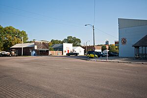
A view of Lynch Nebraska
|
|

Location within Boyd County
|
|
| Country | |
| State | Nebraska |
| County | Boyd |
| Government | |
| • Type | Mayor–council |
| Area | |
| • Total | 0.53 sq mi (1.38 km2) |
| • Land | 0.53 sq mi (1.38 km2) |
| • Water | 0.00 sq mi (0.00 km2) |
| Elevation | 1,411 ft (430 m) |
| Population
(2020)
|
|
| • Total | 194 |
| • Density | 363.30/sq mi (140.31/km2) |
| Time zone | UTC-6 (Central (CST)) |
| • Summer (DST) | UTC-5 (CDT) |
| ZIP code |
68746
|
| Area code(s) | 402 |
| FIPS code | 31-29750 |
| GNIS feature ID | 2399206 |
Lynch is a village in Boyd County, Nebraska, United States. The population was 194 at the 2020 census, down from 245 in 2010. Lynch is located in northern Nebraska, between the Missouri and Niobrara rivers.
History
Lynch was incorporated as a village in 1892. It was named for John Lynch, a pioneer settler.
Thirty of the one hundred homes in Lynch were destroyed by flooding in 2019.
Geography
According to the United States Census Bureau, the village has a total area of 0.53 square miles (1.37 km2), all land.
Climate
This climatic region is typified by large seasonal temperature differences, with warm to hot (and often humid) summers and cold (sometimes severely cold) winters. According to the Köppen Climate Classification system, Lynch has a humid continental climate, abbreviated "Dfa" on climate maps.
| Climate data for Lynch, Nebraska | |||||||||||||
|---|---|---|---|---|---|---|---|---|---|---|---|---|---|
| Month | Jan | Feb | Mar | Apr | May | Jun | Jul | Aug | Sep | Oct | Nov | Dec | Year |
| Mean daily maximum °C (°F) | 0.4 (32.8) |
3.1 (37.5) |
9.4 (49.0) |
15.8 (60.4) |
21.9 (71.5) |
27.7 (81.9) |
31.2 (88.1) |
30.0 (86.0) |
25.7 (78.3) |
17.9 (64.2) |
9.5 (49.1) |
2.3 (36.2) |
16.3 (61.3) |
| Daily mean °C (°F) | −6.6 (20.1) |
−4.4 (24.1) |
1.8 (35.3) |
8.1 (46.5) |
14.6 (58.2) |
20.7 (69.2) |
23.9 (75.0) |
22.6 (72.6) |
17.6 (63.6) |
9.6 (49.3) |
1.8 (35.2) |
−4.6 (23.8) |
8.8 (47.7) |
| Mean daily minimum °C (°F) | −13.7 (7.4) |
−11.8 (10.8) |
−5.7 (21.7) |
0.4 (32.7) |
7.2 (45.0) |
13.6 (56.4) |
16.6 (61.9) |
15.2 (59.3) |
9.4 (49.0) |
1.3 (34.4) |
−5.9 (21.3) |
−11.5 (11.3) |
1.3 (34.3) |
| Average precipitation mm (inches) | 13 (0.5) |
20 (0.8) |
38 (1.5) |
69 (2.7) |
86 (3.4) |
94 (3.7) |
76 (3) |
71 (2.8) |
58 (2.3) |
43 (1.7) |
20 (0.8) |
15 (0.6) |
600 (23.7) |
| Average snowfall cm (inches) | 14.2 (5.6) |
17.5 (6.9) |
17 (6.7) |
5.6 (2.2) |
0 (0) |
0 (0) |
0 (0) |
0 (0) |
0 (0) |
1.5 (0.6) |
10.4 (4.1) |
15 (5.9) |
81.2 (32) |
| Average precipitation days | 4 | 4 | 6 | 7 | 9 | 9 | 7 | 7 | 6 | 5 | 4 | 4 | 72 |
| Average snowy days | 2.9 | 2.3 | 2.8 | 0.9 | 0 | 0 | 0 | 0 | 0 | 0.3 | 2 | 2.5 | 13.7 |
| Source 1: NOAA(temperatures 1991-2020) | |||||||||||||
| Source 2: Weatherbase(precipitation - snow) | |||||||||||||
Demographics
| Historical population | |||
|---|---|---|---|
| Census | Pop. | %± | |
| 1900 | 231 | — | |
| 1910 | 583 | 152.4% | |
| 1920 | 589 | 1.0% | |
| 1930 | 498 | −15.4% | |
| 1940 | 487 | −2.2% | |
| 1950 | 440 | −9.7% | |
| 1960 | 409 | −7.0% | |
| 1970 | 375 | −8.3% | |
| 1980 | 357 | −4.8% | |
| 1990 | 296 | −17.1% | |
| 2000 | 269 | −9.1% | |
| 2010 | 245 | −8.9% | |
| 2020 | 194 | −20.8% | |
| U.S. Decennial Census | |||
2020 census
As of the 2020 census, there was a population of 194 and 144 households. The population density was 462.3 inhabitants per square mile (178.5/km2). There were 190 housing units at an average density of 337.7 units per square mile (130.4 units/km2). The racial makeup of the village was 99% White. Only two of all the residents are of any race.
22% of the village has a bachelor's degree education or higher, and the village has a 57% employment rate. 13% of the residents in the village do not have health care coverage. The Median Household income is $38,250.
Education
The area is within Boyd County Public Schools. The area was previously within the Lynch Public Schools district. The Lynch district consolidated into the Boyd County district in June 2017.
See also
 In Spanish: Lynch (Nebraska) para niños

