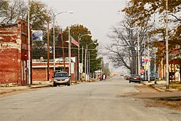
Luxora, Arkansas facts for kids
Quick facts for kids
Luxora, Arkansas
|
|
|---|---|
 |
|

Location in Mississippi County, Arkansas
|
|
| Country | United States |
| State | Arkansas |
| County | Mississippi |
| Incorporated | 1897 |
| Named for | Luxora Waller |
| Area | |
| • Total | 0.85 sq mi (2.20 km2) |
| • Land | 0.85 sq mi (2.20 km2) |
| • Water | 0.00 sq mi (0.00 km2) |
| Elevation | 246 ft (75 m) |
| Population
(2020)
|
|
| • Total | 942 |
| • Density | 1,106.93/sq mi (427.44/km2) |
| Time zone | UTC-6 (Central (CST)) |
| • Summer (DST) | UTC-5 (CDT) |
| ZIP code |
72358
|
| Area code(s) | 870 |
| FIPS code | 05-42170 |
| GNIS feature ID | 2404978 |
Luxora is a city in Mississippi County, Arkansas, United States. The population was 942 at the 2020 census, down from 1,178 in 2010.
History
The city was originally settled as the community of Elmot Landing in the 1880s next to the Mississippi River. By 1897, the town had moved inland, behind the federal levee and was incorporated as Luxora, named after the daughter of a local businessman.
During World War II, the Civil Aeronautics Authority operated an intermediate landing field in the vicinity of Luxora. This field was also utilized by Air Cadets at Blytheville Army Airfield and Walnut Ridge Army Air Field during the war.
Geography
Luxora is located in eastern Mississippi County, Arkansas. It is bordered to the southeast by the Tennessee state line, which follows a side channel of the Mississippi River. U.S. Route 61 passes through the northwest side of the city, leading north 14 miles (23 km) to Blytheville and southwest 5 miles (8 km) to Osceola.
According to the United States Census Bureau, the city has a total area of 0.9 square miles (2.3 km2), in terms of geographical area.
Demographics
| Historical population | |||
|---|---|---|---|
| Census | Pop. | %± | |
| 1900 | 943 | — | |
| 1910 | 677 | −28.2% | |
| 1920 | 1,179 | 74.2% | |
| 1930 | 1,074 | −8.9% | |
| 1940 | 1,258 | 17.1% | |
| 1950 | 1,302 | 3.5% | |
| 1960 | 1,236 | −5.1% | |
| 1970 | 1,566 | 26.7% | |
| 1980 | 1,739 | 11.0% | |
| 1990 | 1,338 | −23.1% | |
| 2000 | 1,317 | −1.6% | |
| 2010 | 1,178 | −10.6% | |
| 2020 | 942 | −20.0% | |
| U.S. Decennial Census | |||
2020 census
| Race | Number | Percentage |
|---|---|---|
| White (non-Hispanic) | 333 | 35.35% |
| Black or African American (non-Hispanic) | 533 | 56.58% |
| Native American | 1 | 0.11% |
| Other/Mixed | 32 | 3.4% |
| Hispanic or Latino | 43 | 4.56% |
As of the 2020 United States census, there were 942 people, 358 households, and 200 families residing in the city.
2010 census
As of the 2010 United States Census, there were 1,178 people living in the town. The racial makeup of the town was 60.8% Black, 33.1% White, 0.5% Native American and 1.0% from two or more races. 4.6% were Hispanic or Latino of any race.
Education
Public education for elementary and secondary students is provided by the Rivercrest School District (formerly the Southern Mississippi County School District), which includes the Southern Mississippi County Elementary School at Luxora (prekindergarten through grade 4). Students graduate from Rivercrest High School located near Wilson.
On July 1, 1986, the Luxora School District consolidated into the Southern Mississippi County School District.
See also
 In Spanish: Luxora (Arkansas) para niños

