Lund Municipality facts for kids
Quick facts for kids
Lunds kommun
|
||
|---|---|---|

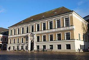
Lund City Hall
|
||
|
||
 |
||
| Country | Sweden | |
| County | Scania County | |
| Seat | Lund | |
| Area | ||
| • Total | 442.87 km2 (170.99 sq mi) | |
| • Land | 430.27 km2 (166.13 sq mi) | |
| • Water | 12.6 km2 (4.9 sq mi) | |
| Area as of January 1, 2010. | ||
| Population
(June 30, 2012)
|
||
| • Total | 108,947 | |
| • Density | 246.002/km2 (637.143/sq mi) | |
| Time zone | UTC+1 (CET) | |
| • Summer (DST) | UTC+2 (CEST) | |
| ISO 3166 code | SE | |
| Province | Scania | |
| Municipal code | 1281 | |
| Density is calculated using land area only. | ||
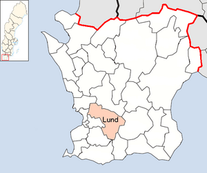
Lund Municipality (Swedish: Lunds kommun) is a municipality in Scania County, southern Sweden. Its seat is the city of Lund.
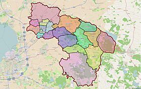
As most municipalities in Sweden, the territory of municipality consists of many former local government units, united in a series of amalgamations. The number of original entities (as of 1863) is 22. At the time of the nationwide municipal reform of 1952 the number had been reduced to six. In 1967 the rural municipality Torn (itself created in 1952) was added to Lund. The City of Lund was made a unitary municipality in 1971 and amalgamated with Dalby, Genarp, Södra Sandby and Veberöd in 1974 completing the process. Since 2016, the municipality is subdivided into 16 districts for the purposes of population and land registration.
Dalby Söderskog, one of Sweden's national parks, is located within the municipality near Dalby. The municipal bird of Lund is the Eurasian penduline tit.
Contents
Localities
There are nine urban areas in Lund Municipality:
| # | Locality | Population |
|---|---|---|
| 1 | Lund | 91,940 |
| 2 | Dalby | 6,486 |
| 3 | Södra Sandby | 6,285 |
| 4 | Veberöd | 4,971 |
| 5 | Genarp | 2,956 |
| 6 | Stångby | 2,032 |
| 7 | Torna Hällestad | 713 |
| 8 | Revingeby | 536 |
| 9 | Vallkärra | 425 |
Demographics
This is a demographic table based on Lund Municipality's electoral districts in the 2022 Swedish general election sourced from SVT's election platform, in turn taken from SCB official statistics.
In total there were 127,202 residents, including 93,503 Swedish citizens of voting age. 57.1% voted for the left coalition and 41.4% for the right coalition. This was in stark contrast to the rest of the Skåne Southern constituency, that was won by the right with a sizeable margin. Indicators are in percentage points except population totals and income.
| Location | Residents | Citizen adults |
Left vote | Right vote | Employed | Swedish parents |
Foreign heritage |
Income SEK |
Degree |
|---|---|---|---|---|---|---|---|---|---|
| % | % | ||||||||
| Annehem | 1,896 | 1,330 | 49.6 | 49.8 | 83 | 75 | 25 | 44,129 | 89 |
| Brunnshög | 1,175 | 942 | 57.2 | 41.5 | 66 | 61 | 39 | 16,877 | 76 |
| Centrum, Clemens rote | 1,290 | 1,134 | 57.5 | 41.5 | 64 | 77 | 23 | 25,871 | 77 |
| Centrum, Drottens rote | 1,663 | 1,416 | 54.9 | 43.7 | 70 | 81 | 19 | 27,856 | 80 |
| Centrum, Färgaren | 1,390 | 1,118 | 59.4 | 38.3 | 63 | 73 | 27 | 20,738 | 74 |
| Centrum, Krafts rote | 1,246 | 1,084 | 54.6 | 44.1 | 58 | 76 | 24 | 18,322 | 80 |
| Centrum, Vårfru rote | 1,426 | 1,294 | 53.6 | 45.3 | 53 | 82 | 18 | 14,157 | 78 |
| Dalby, C-Nyvång | 1,568 | 1,143 | 51.7 | 47.4 | 79 | 81 | 19 | 26,561 | 65 |
| Dalby Kolonin | 1,652 | 1,193 | 57.5 | 41.2 | 78 | 83 | 17 | 25,714 | 58 |
| Dalby, Norrevång | 1,628 | 1,173 | 52.3 | 46.4 | 82 | 88 | 12 | 30,333 | 65 |
| Dalby, Pinnmöllan | 1,222 | 810 | 62.0 | 36.9 | 83 | 86 | 14 | 29,543 | 62 |
| Dalby, Stationen | 1,579 | 941 | 47.7 | 51.3 | 79 | 77 | 23 | 30,236 | 58 |
| Delfi | 1,438 | 954 | 64.0 | 33.2 | 19 | 59 | 41 | 1,556 | 92 |
| Fäladstorget | 981 | 678 | 60.3 | 37.4 | 70 | 53 | 47 | 23,348 | 79 |
| Galjevången | 1,771 | 1,406 | 53.2 | 45.3 | 55 | 78 | 22 | 17,001 | 84 |
| Genarp, Ekesvång | 1,839 | 1,400 | 39.7 | 59.0 | 85 | 87 | 13 | 30,367 | 51 |
| Genarp, Slätterna | 2,270 | 1,537 | 43.8 | 55.1 | 83 | 80 | 20 | 29,277 | 52 |
| Gunnesbo, Fornängen | 1,745 | 1,331 | 58.3 | 39.5 | 80 | 68 | 32 | 28,371 | 56 |
| Gunnesboparken | 1,931 | 1,426 | 62.3 | 35.5 | 73 | 59 | 41 | 26,138 | 61 |
| Gylleholm | 1,188 | 752 | 60.5 | 38.1 | 33 | 64 | 36 | 3,623 | 86 |
| Hospitalsgården | 1,781 | 1,406 | 58.4 | 40.4 | 74 | 74 | 26 | 24,952 | 71 |
| Klostergården C | 1,365 | 895 | 65.5 | 33.1 | 64 | 51 | 49 | 19,850 | 60 |
| Klostergården N | 1,156 | 902 | 49.7 | 48.5 | 76 | 71 | 29 | 30,768 | 72 |
| Klostergården SV | 1,613 | 1,365 | 64.4 | 34.6 | 76 | 77 | 23 | 24,185 | 66 |
| Klostergården SÖ | 1,387 | 862 | 67.9 | 28.2 | 52 | 41 | 59 | 14,222 | 59 |
| Klosterhusen | 1,491 | 1,231 | 61.3 | 38.0 | 68 | 80 | 20 | 24,411 | 77 |
| Kobjer-Sliparelyckan | 1,765 | 1,330 | 67.9 | 31.1 | 74 | 77 | 23 | 28,794 | 80 |
| Ladugårdsmarken | 1,640 | 1,058 | 60.9 | 36.5 | 71 | 47 | 53 | 25,172 | 63 |
| Linero, Gårdarike | 1,661 | 1,179 | 57.2 | 41.2 | 79 | 60 | 40 | 30,157 | 69 |
| Linero, Tre högars park | 1,744 | 1,342 | 59.5 | 39.0 | 69 | 62 | 38 | 25,869 | 64 |
| Linero, Vikingaparken | 1,378 | 922 | 66.4 | 28.9 | 48 | 30 | 70 | 12,972 | 43 |
| Mårtens Fälad | 2,062 | 1,426 | 60.7 | 38.4 | 82 | 75 | 25 | 34,977 | 82 |
| Mårtenslund | 1,176 | 1,026 | 55.7 | 43.1 | 66 | 80 | 20 | 21,555 | 78 |
| Måsen | 1,151 | 920 | 58.7 | 40.3 | 64 | 74 | 26 | 23,028 | 81 |
| Möllevången V | 1,166 | 851 | 58.2 | 40.7 | 67 | 69 | 31 | 26,199 | 80 |
| Möllevången Ö | 1,175 | 810 | 59.2 | 38.9 | 57 | 68 | 32 | 17,073 | 78 |
| N Fäladen, Borgareparken | 1,657 | 1,277 | 66.9 | 31.6 | 62 | 73 | 27 | 27,003 | 86 |
| N Fäladen, Kämnärsr. NV | 957 | 690 | 68.5 | 28.7 | 38 | 65 | 35 | 4,131 | 87 |
| N Fäladen, Kämnärsr. SÖ | 1,063 | 698 | 65.9 | 32.1 | 26 | 65 | 35 | 2,689 | 90 |
| N Fäladen, Rådhusr. | 1,262 | 835 | 75.2 | 23.0 | 57 | 33 | 67 | 14,685 | 48 |
| Nilstorp | 1,882 | 1,377 | 59.4 | 39.5 | 74 | 85 | 15 | 31,168 | 84 |
| Norra Nöbbelöv | 802 | 595 | 59.7 | 38.8 | 82 | 77 | 23 | 32,395 | 83 |
| Norränga | 1,458 | 929 | 57.1 | 40.5 | 66 | 47 | 53 | 19,207 | 51 |
| Nöbbelöv-Oscarshem | 1,783 | 1,277 | 58.4 | 40.5 | 82 | 74 | 26 | 31,904 | 77 |
| Nöbbelöv C | 1,551 | 1,109 | 55.7 | 40.7 | 70 | 56 | 44 | 21,117 | 54 |
| Nöden | 1,471 | 1,248 | 58.7 | 40.8 | 61 | 78 | 22 | 18,456 | 79 |
| Offerkällan | 1,496 | 1,104 | 62.9 | 32.4 | 69 | 44 | 56 | 21,349 | 59 |
| Olshög-Professorsstaden | 1,731 | 1,361 | 51.1 | 46.4 | 57 | 76 | 24 | 26,569 | 83 |
| Papegojelyckan V | 1,898 | 1,385 | 69.9 | 28.7 | 68 | 59 | 41 | 20,587 | 61 |
| Papegojelyckan Ö | 1,629 | 1,331 | 58.3 | 40.0 | 73 | 77 | 23 | 25,307 | 76 |
| Pilelyckan-Rådmansvången | 1,420 | 1,093 | 66.6 | 31.3 | 72 | 76 | 24 | 24,201 | 74 |
| Plantagelyckan | 1,630 | 1,396 | 55.4 | 43.5 | 71 | 80 | 20 | 27,436 | 81 |
| Revingelyckan-Margretedal | 1,543 | 1,402 | 53.7 | 44.9 | 69 | 82 | 18 | 26,186 | 80 |
| Råbylund | 2,278 | 1,336 | 53.6 | 45.2 | 75 | 64 | 36 | 30,268 | 73 |
| Sandby C | 1,407 | 1,034 | 49.1 | 50.2 | 77 | 82 | 18 | 24,411 | 47 |
| Sandby, Fågelsång | 2,060 | 1,491 | 52.6 | 46.7 | 86 | 83 | 17 | 32,064 | 70 |
| Sandby, Kyrkovång | 2,026 | 1,410 | 48.7 | 50.3 | 85 | 82 | 18 | 31,495 | 63 |
| Sandby, Västervång | 1,291 | 905 | 50.1 | 48.3 | 86 | 84 | 16 | 31,453 | 65 |
| Sandby, Östervång | 1,932 | 1,407 | 45.8 | 53.2 | 86 | 85 | 15 | 30,006 | 61 |
| Sankt Hans park | 1,144 | 750 | 68.2 | 29.3 | 65 | 43 | 57 | 24,396 | 72 |
| Sankt Lars | 2,060 | 1,349 | 61.3 | 37.5 | 75 | 64 | 36 | 28,107 | 71 |
| Spoletorp V | 1,576 | 1,360 | 50.1 | 48.6 | 78 | 83 | 17 | 33,598 | 84 |
| Spoletorp Ö | 1,588 | 1,199 | 59.5 | 39.3 | 52 | 70 | 30 | 15,679 | 82 |
| Stampelyckan-Planetstaden | 1,344 | 1,096 | 60.7 | 38.8 | 59 | 78 | 22 | 15,635 | 83 |
| Torn | 1,938 | 1,255 | 52.7 | 46.4 | 86 | 80 | 20 | 34,184 | 69 |
| Torna Hällestad | 1,016 | 727 | 63.0 | 35.2 | 84 | 88 | 12 | 32,983 | 77 |
| Tuna | 1,594 | 1,219 | 58.1 | 40.5 | 28 | 67 | 33 | 3,263 | 89 |
| Ulrikedal | 1,106 | 999 | 66.6 | 31.9 | 35 | 73 | 27 | 4,465 | 92 |
| Vallkärra | 1,783 | 1,166 | 58.9 | 40.8 | 84 | 81 | 19 | 35,582 | 78 |
| Veberöd, Björkhaga | 1,772 | 1,202 | 38.4 | 60.9 | 84 | 85 | 15 | 30,914 | 45 |
| Veberöd, Gamla byn | 1,625 | 1,222 | 40.5 | 59.1 | 81 | 86 | 14 | 25,127 | 46 |
| Veberöd, Idala | 1,666 | 1,158 | 39.6 | 58.9 | 88 | 88 | 12 | 31,394 | 57 |
| Veberöd Raggeborg | 1,413 | 1,012 | 40.7 | 58.5 | 84 | 86 | 14 | 27,349 | 45 |
| Vildanden | 1,658 | 993 | 68.4 | 29.9 | 42 | 47 | 53 | 4,413 | 84 |
| Vipelyckan | 1,577 | 1,374 | 55.5 | 43.8 | 73 | 78 | 22 | 26,464 | 76 |
| Värpinge-Klosters Fälad | 1,517 | 1,082 | 58.0 | 40.7 | 74 | 68 | 32 | 26,979 | 68 |
| Värpinge gård | 1,841 | 1,391 | 64.1 | 34.1 | 72 | 60 | 40 | 23,601 | 62 |
| Väster | 1,436 | 1,175 | 59.0 | 39.0 | 72 | 75 | 25 | 26,322 | 72 |
| Ö Torn, Gåsaftonen | 1,622 | 1,223 | 63.3 | 35.2 | 71 | 66 | 34 | 26,237 | 73 |
| Ö Torn, Orkesterparken | 1,549 | 998 | 65.6 | 33.1 | 76 | 68 | 32 | 29,957 | 79 |
| Ö Torn, Spexaren | 1,769 | 1,149 | 77.5 | 20.4 | 80 | 74 | 26 | 31,851 | 82 |
| Ö Torn, Vänortsparken | 1,772 | 1,127 | 59.9 | 38.2 | 70 | 57 | 43 | 29,097 | 78 |
| Source: SVT | |||||||||
Municipal council
In the 2018 municipal election, no bloc was able to gain control of the executive, a five-party minority coalition consisting of the four Alliance parties and local party FörNyaLund was formed as a result. Philip Sandberg of the Liberals heads the executive. The election results are presented in the table below. The turnout was 86.37%.
| Party | Votes | % | Seats | ± | |
|---|---|---|---|---|---|
| Social Democrats | 16,348 | 20.39 | 13 | −2 | |
| Moderate Party | 13,169 | 16.43 | 11 | −2 | |
| Liberals | 10,753 | 13.41 | 9 | +2 | |
| Green Party | 7,623 | 9.51 | 6 | −3 | |
| Sweden Democrats | 7,544 | 9.41 | 6 | +1 | |
| Left Party | 6,899 | 8.61 | 6 | +1 | |
| FörNyaLund | 6,870 | 8.57 | 6 | +2 | |
| Centre Party | 5,020 | 6.26 | 4 | +1 | |
| Feminist Initiative | 2,285 | 2.85 | 2 | 0 | |
| Christian Democrats | 2,162 | 2.70 | 2 | 0 | |
| Others | 1,492 | 1.86 | |||
| Invalid/blank votes | 828 | ||||
| Total | 80,993 | 86.37 | 65 | - | |
International relations
Twin towns — sister cities
The municipality is twinned with the following local government areas:
 Viborg Municipality
 Hamar Municipality
 Porvoo
 Dalvíkurbyggð
See also
 In Spanish: Municipio de Lund (Suecia) para niños


