Lowndes County, Mississippi facts for kids
Quick facts for kids
Lowndes County
|
|
|---|---|

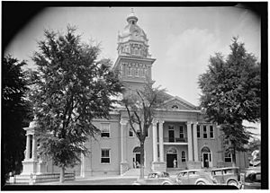
Lowndes County Courthouse in Columbus
|
|

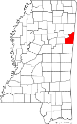
Location within the U.S. state of Mississippi
|
|
 Mississippi's location within the U.S. |
|
| Country | |
| State | |
| Founded | 1830 |
| Named for | William Jones Lowndes |
| Seat | Columbus |
| Largest city | Columbus |
| Area | |
| • Total | 516 sq mi (1,340 km2) |
| • Land | 506 sq mi (1,310 km2) |
| • Water | 11 sq mi (30 km2) 2.1% |
| Population
(2020)
|
|
| • Total | 58,879 |
| • Density | 114.11/sq mi (44.06/km2) |
| Time zone | UTC−6 (Central) |
| • Summer (DST) | UTC−5 (CDT) |
| Congressional district | 1st |
Lowndes County is a county on the eastern border of the U.S. state of Mississippi. As of the 2020 United States Census, the population was 58,879. Its county seat is Columbus. The county is named for U.S. Congressman William Jones Lowndes.
Lowndes County comprises the Columbus, MS Micropolitan Statistical Area. Since the late 20th century, it has been designated as one of three counties in the Golden Triangle region of the state.
Contents
History
This upland area was settled by European Americans who wanted to develop cotton plantations to produce what became the largest commodity crop in the state.
Geography
Lowndes County lies on the east side of Mississippi, bordering the U.S. state of Alabama. Its terrain was completely wooded before settlement; at present its more level areas have been cleared and turned to agricultural or urban use, with the drainages (about 40% of the total area) still wooded. The Tennessee−Tombigbee Waterway flows south-southeastward through the center of the county, with a significant lock system (John C. Stennis Lock and Dam) near Columbus. The county's highest point (450 feet/140 meters ASL) is a small rise near the county's NE corner.
According to the United States Census Bureau, the county has a total area of 516 square miles (1,340 km2), of which 506 square miles (1,310 km2) is land and 11 square miles (28 km2) (2.1%) is water.
Major highways
Adjacent counties
- Noxubee County - south
- Oktibbeha County - west
- Clay County - northwest
- Monroe County - north
- Lamar County, Alabama - northeast
- Pickens County, Alabama - southeast
Demographics
| Historical population | |||
|---|---|---|---|
| Census | Pop. | %± | |
| 1830 | 3,173 | — | |
| 1840 | 14,513 | 357.4% | |
| 1850 | 19,544 | 34.7% | |
| 1860 | 23,625 | 20.9% | |
| 1870 | 30,502 | 29.1% | |
| 1880 | 28,244 | −7.4% | |
| 1890 | 27,047 | −4.2% | |
| 1900 | 29,095 | 7.6% | |
| 1910 | 30,703 | 5.5% | |
| 1920 | 27,632 | −10.0% | |
| 1930 | 29,987 | 8.5% | |
| 1940 | 35,245 | 17.5% | |
| 1950 | 37,852 | 7.4% | |
| 1960 | 46,639 | 23.2% | |
| 1970 | 49,700 | 6.6% | |
| 1980 | 57,304 | 15.3% | |
| 1990 | 59,308 | 3.5% | |
| 2000 | 61,586 | 3.8% | |
| 2010 | 59,779 | −2.9% | |
| 2020 | 58,879 | −1.5% | |
| 2023 (est.) | 57,283 | −4.2% | |
| US Decennial Census 1790-1960 1900-1990 1990-2000 2010-2013 |
|||
2020 census
| Race | Num. | Perc. |
|---|---|---|
| White | 29,363 | 49.87% |
| Black or African American | 25,885 | 43.96% |
| Native American | 110 | 0.19% |
| Asian | 514 | 0.87% |
| Pacific Islander | 16 | 0.03% |
| Other/Mixed | 1,668 | 2.83% |
| Hispanic or Latino | 1,323 | 2.25% |
As of the 2020 United States Census, there were 58,879 people, 22,436 households, and 14,654 families residing in the county.
2010 census
As of the 2010 United States Census, there were 59,779 people in the county. 54.0% were White, 43.5% Black or African American, 0.7% Asian, 0.2% Native American, 0.1% Pacific Islander, 0.6% of some other race and 1.1% of two or more races. 1.5% were Hispanic or Latino (of any race).
Education
Primary and secondary schools
Portions of Lowndes County are served by the Columbus Municipal School District, Lowndes County School District, and the Mississippi Association of Independent Schools – Lowndes County Division.
The Columbus Municipal School District includes:
- Columbus High School
- Columbus Middle School
- McKellar Technology Center
- Joe Cook Elementary Fine Arts Magnet School
- Fairview Elementary Aerospace and Science Magnet School
- Franklin Academy Elementary Medical Sciences and Wellness Magnet School
- Sale Elementary International Studies Magnet School
- Stokes-Beard Elementary Communication and Technology Magnet School
- Columbus Alternative School
The Lowndes County School District has three areas, each with an elementary school, a middle school, and a high school
- Caledonia Schools
- New Hope Schools
- West Lowndes Schools
The Mississippi Association of Independent Schools – Lowndes County Division has provided five private and parochial schools for Lowndes County
- Heritage Academy High School
- Heritage Academy Elementary School
- Columbus Christian Academy
- Victory Christian Academy
- Annunciation Catholic School
Colleges and universities
Mississippi University for Women is located in Columbus. Lowndes County is within the service area of the East Mississippi Community College system. The Golden Triangle Campus is located in Mayhew, an unincorporated area in Lowndes County. The system also offers classes at the Columbus Air Force Base Extension in Columbus.
Communities
City
- Columbus (county seat)
Town
Census-designated places
- Columbus Air Force Base
- New Hope
Unincorporated communities
Ghost towns
See also
 In Spanish: Condado de Lowndes (Misisipi) para niños


