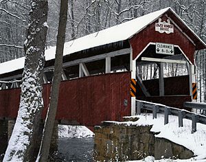
Lower Humbert Covered Bridge facts for kids
Quick facts for kids Lower Humbert Covered Bridge |
|
|---|---|
 |
|
| Coordinates | 39°50′24.5″N 79°19′23″W / 39.840139°N 79.32306°W |
| Carries | Township 312 |
| Crosses | Laurel Hill Creek |
| Locale | Somerset, Pennsylvania, United States |
| Other name(s) | Faidley Covered Bridge |
| Maintained by | Somerset County |
| NBI Number | 557213031230350 |
| Characteristics | |
| Total length | 126.5 ft (38.6 m) |
| Width | 12.3 ft (3.7 m) |
| Height | 8 ft (2.4 m) |
| Load limit | 3 short tons (2.7 t) |
| MPS | Covered Bridges of Somerset County TR |
| NRHP reference No. | 80003638 |
| Added to NRHP | December 10, 1980 |
| Lua error in Module:Location_map at line 420: attempt to index field 'wikibase' (a nil value). | |
The Lower Humbert Covered Bridge, or the Faidley Covered Bridge, is an 126-foot-6-inch (38.56 m) Burr Arch truss covered bridge that crosses Laurel Hill Creek, in Lower Turkeyfoot Township, Somerset County in the U.S. state of Pennsylvania. It was built in 1891 and was listed on the National Register of Historic Places on December 10, 1980. It is one of the ten remaining covered bridges in Somerset County.
History
The covered bridge was built in 1891. It was rebuilt in 1991, with extensive reinforcement work done on the abutments. A homemade explosive device caused minor damage to bridge deck in January 2006.

All content from Kiddle encyclopedia articles (including the article images and facts) can be freely used under Attribution-ShareAlike license, unless stated otherwise. Cite this article:
Lower Humbert Covered Bridge Facts for Kids. Kiddle Encyclopedia.
