Lonoke County, Arkansas facts for kids
Quick facts for kids
Lonoke County
|
|
|---|---|
| County of Lonoke | |

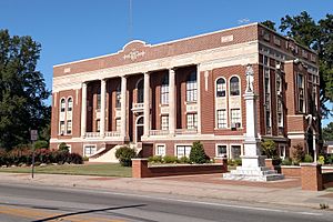
Lonoke County Courthouse
|
|

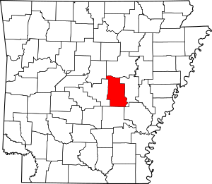
Location within the U.S. state of Arkansas
|
|
 Arkansas's location within the U.S. |
|
| Country | |
| State | |
| Formed | April 16, 1874 |
| Named for | "Lone oak" |
| Seat | Lonoke |
| Largest city | Cabot |
| Area | |
| • Total | 803 sq mi (2,080 km2) |
| • Land | 771 sq mi (2,000 km2) |
| • Water | 32 sq mi (80 km2) 4.0%% |
| Population
(2020)
|
|
| • Total | 74,015 |
| • Density | 92.17/sq mi (35.588/km2) |
| Time zone | UTC−6 (Central) |
| • Summer (DST) | UTC−5 (CDT) |
| ZIP Codes |
72007, 72023, 72024, 72037, 72046, 72072, 72076, 72083, 72086, 72142, 72160, 72176
|
| Congressional district | 1st |
Lonoke County is a county located in the Central Arkansas region of the U.S. state of Arkansas. As of the 2020 census, the population was 74,015, making it the 10th-most populous of Arkansas's 75 counties. The county seat is Lonoke and largest city is Cabot. Included in the Central Arkansas metropolitan area, with Little Rock as the principal city, it is an alcohol prohibition or dry county.
Contents
Etymology
Lonoke County was named for the "lone oak" located in the county at the time of its formation, by simply spelling it phonetically, at the suggestion of the chief engineer of the Cairo & Fulton Railroad.
History
Formed on April 16, 1873, from Pulaski and Prairie counties, Lonoke County's varied geography can be roughly broken into thirds horizontally. The top third has rolling hills at the edge of the Ozarks, including the Cabot area. The middle third, including the Lonoke area, contains portions of the Grand Prairie, a flat native grassland today known for rice farming, an important part of the culture, economy and history of Lonoke County. The southern third, including the Scott area, is home to the alluvial soils of the Arkansas Delta. Historically, a military road and a railroad brought settlers to the area, and cotton cultivation was very profitable. In 1904, a demonstration that rice could grow well on the same land coupled with sinking cotton prices drove the area into rice cultivation. During World Wars I and II, Lonoke County was home to Eberts Field, a U.S. Army airfield. Today the land is used in aquaculture.
Geography
According to the U.S. Census Bureau, the county has a total area of 803 square miles (2,080 km2), of which 771 square miles (2,000 km2) is land and 32 square miles (83 km2) (4.0%) is water.
Major highways
 Interstate 40
 Future Interstate 57
 U.S. Highway 67
 U.S. Highway 70
 U.S. Highway 165
 U.S. Highway 167
 Highway 5
 Highway 13
 Highway 15
 Highway 31
 Highway 38
 Highway 89
Adjacent counties
- White County (north)
- Prairie County (east)
- Arkansas County (southeast)
- Jefferson County (south)
- Pulaski County (west)
- Faulkner County (northwest)
Demographics
| Historical population | |||
|---|---|---|---|
| Census | Pop. | %± | |
| 1880 | 12,146 | — | |
| 1890 | 19,263 | 58.6% | |
| 1900 | 22,544 | 17.0% | |
| 1910 | 27,983 | 24.1% | |
| 1920 | 33,400 | 19.4% | |
| 1930 | 33,759 | 1.1% | |
| 1940 | 29,802 | −11.7% | |
| 1950 | 27,278 | −8.5% | |
| 1960 | 24,551 | −10.0% | |
| 1970 | 26,249 | 6.9% | |
| 1980 | 34,518 | 31.5% | |
| 1990 | 39,268 | 13.8% | |
| 2000 | 52,828 | 34.5% | |
| 2010 | 68,356 | 29.4% | |
| 2020 | 74,015 | 8.3% | |
| 2023 (est.) | 75,944 | 11.1% | |
| U.S. Decennial Census 1790–1960 1900–1990 1990–2000 2010 |
|||
2020 census
| Race | Number | Percentage |
|---|---|---|
| White (non-Hispanic) | 60,596 | 81.87% |
| Black or African American (non-Hispanic) | 4,349 | 5.88% |
| Native American | 314 | 0.42% |
| Asian | 716 | 0.97% |
| Pacific Islander | 49 | 0.07% |
| Other/Mixed | 4,381 | 5.92% |
| Hispanic or Latino | 3,610 | 4.88% |
As of the 2020 United States census, there were 74,015 people, 26,052 households, and 18,824 families residing in the county.
Communities
Cities
Towns
Census-designated place
Townships
Townships in Arkansas are the divisions of a county. Each township includes unincorporated areas; some may have incorporated cities or towns within part of their boundaries. Arkansas townships have limited purposes in modern times. However, the United States Census does list Arkansas population based on townships (sometimes referred to as "county subdivisions" or "minor civil divisions"). Townships are also of value for historical purposes in terms of genealogical research. Each town or city is within one or more townships in an Arkansas county based on census maps and publications. The townships of Lonoke County are listed below; listed in parentheses are the cities, towns, and/or census-designated places that are fully or partially inside the township.
- Butler
- Carlisle (Carlisle)
- Caroline (Austin, small part of Cabot, part of Ward)
- Cleveland
- Crooked Creek (Allport, Humnoke)
- Dortch (CDP Scott)
- Eagle
- Fletcher
- Furlow
- Goodrum
- Gray
- Gum Woods (England)
- Hamilton
- Indian Bayou (Coy)
- Isbell
- Lafayette (Keo)
- Lonoke (Lonoke)
- Magness (part of Cabot)
- Oak Grove (small part of Cabot)
- Pettus
- Prairie
- Pulaski
- Richwoods
- Scott
- Totten
- Walls
- Ward (part of Ward)
- Williams
- York (most of Cabot)
Education
School districts include:
- Cabot Public Schools
- Carlisle School District
- Des Arc Public Schools
- England School District
- Jacksonville North Pulaski School District
- Lonoke School District
- Pulaski County Special School District
See also
 In Spanish: Condado de Lonoke para niños


