Locust Grove, Georgia facts for kids
Quick facts for kids
Locust Grove, Georgia
|
|||
|---|---|---|---|
|
City
|
|||

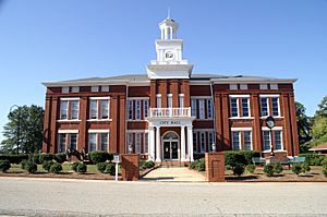
Locust Grove City Hall
|
|||
|
|||

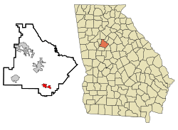
Location in Henry County and the state of Georgia
|
|||
| Country | United States | ||
| State | Georgia | ||
| County | Henry | ||
| Area | |||
| • Total | 11.78 sq mi (30.51 km2) | ||
| • Land | 11.59 sq mi (30.02 km2) | ||
| • Water | 0.19 sq mi (0.49 km2) | ||
| Elevation | 837 ft (255 m) | ||
| Population
(2020)
|
|||
| • Total | 8,947 | ||
| • Density | 771.89/sq mi (298.04/km2) | ||
| Time zone | UTC-5 (Eastern (EST)) | ||
| • Summer (DST) | UTC-4 (EDT) | ||
| ZIP code |
30248
|
||
| Area code | 770/678/470 | ||
| FIPS code | 13-47140 | ||
| GNIS feature ID | 0332253 | ||
Locust Grove is a city in Henry County, Georgia, United States. The population was 8,947 in 2020. Some unincorporated communities such as Luella and many rural areas surround Locust Grove, and those communities have Locust Grove postal addresses.
Locust Grove has experienced a growth in population and in businesses coming into the area. In 1900 the population of the city was 254 and is now over 5,000.
Contents
History
The community was named for a grove of locust trees near the original town site. Georgia General Assembly incorporated Locust Grove in 1893.
Geography
Locust Grove is located in southern Henry County.
According to the United States Census Bureau, the city has a total area of 10.8 square miles (28.1 km2), of which 10.7 square miles (27.6 km2) are land and 0.2 square miles (0.5 km2), or 1.67%, are water.
Demographics
| Historical population | |||
|---|---|---|---|
| Census | Pop. | %± | |
| 1890 | 255 | — | |
| 1900 | 254 | −0.4% | |
| 1910 | 716 | 181.9% | |
| 1920 | 529 | −26.1% | |
| 1930 | 428 | −19.1% | |
| 1940 | 349 | −18.5% | |
| 1950 | 405 | 16.0% | |
| 1960 | 369 | −8.9% | |
| 1970 | 642 | 74.0% | |
| 1980 | 1,479 | 130.4% | |
| 1990 | 1,681 | 13.7% | |
| 2000 | 2,322 | 38.1% | |
| 2010 | 5,402 | 132.6% | |
| 2020 | 8,947 | 65.6% | |
| 2023 (est.) | 11,199 | 107.3% | |
| U.S. Decennial Census 1850-1870 1870-1880 1890-1910 1920-1930 1940 1950 1960 1970 1980 1990 2000 2010 |
|||
| Race | Num. | Perc. |
|---|---|---|
| White (non-Hispanic) | 3,125 | 34.93% |
| Black or African American (non-Hispanic) | 4,627 | 51.72% |
| Native American | 10 | 0.11% |
| Asian | 140 | 1.56% |
| Pacific Islander | 4 | 0.04% |
| Other/Mixed | 431 | 4.82% |
| Hispanic or Latino | 610 | 6.82% |
As of the 2020 United States census, there were 8,947 people, 2,571 households, and 1,837 families residing in the city.
Arts and culture
Attractions
Tanger Outlet Center opened for business in the fall of 1994. Since that time many new businesses have made Locust Grove their home.
Locust Grove is also home to Noah's Ark, a non-profit preserve and rehabilitation facility home to more than 1,000 animals. A group home sharing the site was previously licensed by the state of Georgia to provide residential care for up to 24 children but has since closed.
Locust Grove has a platform for watching the Norfolk Southern line that runs parallel to State Route 42/US Highway 23. It is equipped with a scanner radio that allows visitors to the platform to listen in to the local railroad frequency, which broadcasts out of the defect detector in nearby Jenkinsburg.
Education
Public
Elementary
- Locust Grove Elementary School
- Unity Grove Elementary School
- Luella Elementary School
- New Hope Elementary School
- Bethlehem Elementary School
Middle
- Locust Grove Middle School
- Luella Middle School
- Ola Middle School
High
- Locust Grove High School
- Luella High School
- Ola High School
Private
- Strong Rock Christian School
- Heritage Baptist Christian School
Infrastructure
Major highways
 Interstate 75
 U.S. Highway 23
 Georgia State Route 42
 Georgia State Route 155
 Georgia State Route 401
See also
 In Spanish: Locust Grove (Georgia) para niños


