Lochaber facts for kids
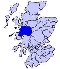
Lochaber (/lɒxˈɑːbər/ lokh-AH-bər; Scottish Gaelic: Loch Abar) is a name applied to a part of the Scottish Highlands. Historically, it was a provincial lordship consisting of the parishes of Kilmallie and Kilmonivaig, as they were before being reduced in extent by the creation of Quoad Sacra parishes in the 19th century. Lochaber once extended from the Northern shore of Loch Leven, a district called Nether Lochaber, to beyond Spean Bridge and Roybridge, which area is known as Brae Lochaber or Braigh Loch Abar in Gaelic. Lochaber is now also used to refer to a much wider area, one of the 16 ward management areas of the Highland Council of Scotland and one of eight former local government districts of the two-tier Highland region. The main town of Lochaber is Fort William.
According to legend, a glaistig, a ghostly woman-goat hybrid, once lived in the area.
Contents
Name
William Watson outlined two schools of thought on this topic. He favoured the idea that Abar came from the Pictish and Welsh for "river mouth" and that Loch Abar meant the confluence of the Lochy and the Nevis as they flowed into Loch Linnhe, an Linne Dhubh in Gaelic. He also conceded that abar might also come from the Gaelic eabar, meaning "mud" or "swampy place". Thus Lochaber could be the "loch of swamps", a historic water feature that existed on the Blàr Mòr, where the area's High School and Health Centre are situated today. Other experts favour the "swamp" derivation. A Lochaber person is called an Abrach.
History

Lochaber is first recorded in the Life of Columba written in c.690 by Adomnán, the Abbot of Iona Abbey. Although there are no known Pictish stones within the area, Ardnamurchan Point is believed to have marked the boundary between the lands ruled by the Picts to the north and east, and those ruled by migrating Irish clans in Dál Riata to the south.
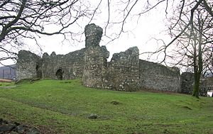
Archaeological evidence of earlier structures supports the tradition that Inverlochy Castle was built on the site of an earlier Pictish settlement, described by the historian Hector Boece in 1526 as a "city ... much frequented with merchants of France and Spain", but destroyed by the Vikings. Lochaber contains no early monastic locations, but the numerous placenames starting with the element "Kil-" or "Cille-" suggest early Christian sites dating from the period 600-900, while the placename element "annat" found near Corpach suggests the site of an early mother church. Placename evidence also suggests the presence of Viking settlements in the Morvern and Ballachulish areas, but nowhere north and east of Fort William.
Lochaber formed part of the Province of Moray from the early 12th century at the latest. It was first recorded as a provincial lordship at the end of the 13th century, but a "Steward of Lochaber" is recorded witnessing a charter sealed by Walter Comyn, Lord of Badenoch in 1234, suggesting that Lochaber had already been granted as a lordship by that date, and had probably, like Badenoch, been granted to Comyn by Alexander II in 1229.
It was therefore one of the seven lordships created within Moray by ca. 1230 that as well as Badenoch included The Aird, Glencarnie, Abernethy, Stratha'an and Strathbogie. The lordship was made up of the two parishes of Kilmallie and Kilmonivaig and had its caput at Inverlochy Castle.
Lochaber was one of the territories that King Robert Bruce gave to his friend, Angus Og Macdonald, Lord of the Isles, who fought at his side during the First War of Independence, including the successful battle of Bannockburn in 1314. In turn, Angus Og gave Ardnamurchan to his younger brother, Iain Sprangach MacDonald (first of the MacDonalds of Ardnamurchan), and he gave to his natural son, Iain Fraoch MacDonald, Glencoe. In 1376, King Robert II confirmed John Macdonald, Lord of the Isles and son of Angus Og Macdonald, control of Colonsay, Kintyre and Knapdale and granted Lochaber to John and his wife Princess Margaret as a part of her dowry. In turn, John of Islay's son, Donald Macdonald, Lord of the Isles, gave the province to his brother, Alexander, who became Lord of Lochaber and the 1st of Keppoch.
In the Middle Ages, Clan Cameron was the principal and dominant clan in Lochaber. Other important clans included: MacDonald of Keppoch, MacDonell of Glengarry, MacMillan and MacIntosh. The Law was intended to be covered by a sheriff based at Inverness; the Sheriffdom also included Skye, Badenoch, and the area west of Inverness between Badenoch and Ross.
Beginning in 1740, Lochaber was the residence of Fr. Alexander Cameron, a nobleman from Clan Cameron and Roman Catholic priest. For years prior to the Uprising of 1745, Fr. Cameron ran a highly successful vicariate for the still illegal and underground Catholic Church in Scotland in both Lochaber and Strathglass. After serving as a military chaplain to the Jacobite Army until the Battle of Culloden in 1746, Fr. Cameron was captured by the British Army and died aboard a prison hulk anchored in the River Thames. Fr. Cameron is currently being promoted by the Knights of St Columba for canonization by the Roman Catholic Church.
Due to the "arbitrary and malicious violence" that Hanoverian Redcoats inflicted, the aftermath of Culloden is still referred to in the Highlands and Islands as Bliadhna nan Creach ("The Year of the Pillaging"). What is worse, according to John Lorne Campbell, "Lochaber suffered more from Hanoverian reprisals and plundering than any other part of the Highlands."
Furthermore, the local population was decimated over the years that followed by both the Highland Clearances and voluntary emigration. One particularly devastating loss in 1816 was a highly important figure to Scottish Gaelic literature: poet, tradition bearer, and Nova Scotia pioneer Ailean a' Ridse MacDhòmhnaill.
So many other local Gaels emigrated voluntarily or were evicted, too, that in 1900, Canadian Gaelic poet Alasdair a' Ridse MacDhòmhnaill wrote, "They say the best singers and Seanachies left Scotland. They left Lochaber for certain."
In the mid 19th century, local government reforms replaced the ancient provinces with new Counties (shires), aligned to sheriffdom boundaries; hence, Lochaber formed the south-western portion of the new shire of Inverness.
Under the Local Government (Scotland) Act 1973, Scottish counties and burghs were abolished, creating a new system of nine two-tier regions and three island council areas. Hence it was that Invernessshire was merged with other Highland areas, to form the new statutory region of Highland. This lasted from 1975 to 1996.
Each region consisted of some districts (the island areas were created as unitary council areas). The Lochaber district was created by merging the Ardnamurchan district and the Ballachulish and Kinlochleven electoral divisions of the former county of Argyll with the burgh of Fort William and the district of Lochaber of the former county of Inverness. Therefore, the boundaries of the district included North Lorne, Glen Coe, Nether Lochaber, the western part of the Rannoch Moor, the Road to the Isles, Moidart, Ardgour, Morvern, Sunart, Ardnamurchan, and the Small Isles (Rùm, Eigg, Muck and Canna).
In 1994 legislation was passed which abolished the regions and districts and established a system of 32 unitary council areas covering the whole of Scotland; all of the Highland districts were merged into the newly unitary Highland council area.
In 1996 the new Highland Council adopted the areas of the former districts as council management areas, and created area committees to represent them. The Lochaber management area then consisted of eight out of the 72 wards of the council area, each electing one councillor by the first past the post system of election. In 1999 ward boundaries were redrawn to create 80 new wards. Management area boundaries were not redrawn, however, and therefore area committees ceased to represent exactly the areas for which they were named and made decisions. The Lochaber committee continued to have eight members. The area manager throughout this period (1996–2007) was John Hutchison.
Ward boundaries were redrawn again in 2007 under the Local Governance (Scotland) Act 2004, and the council abolished its eight management areas in favour of three new corporate management areas and 16 new ward management areas. Each of the 22 new wards elects three or four councillors by the single transferable vote system, a system designed to produce a form of proportional representation, and the total number of councillors remains the same. Various ward management areas, including the Lochaber area, cover more than one ward.
Governance
The Lochaber ward management area is one of five comprising the Highland Council's Ross, Skye and Lochaber corporate management area, which in turn is one of Highland Council's three corporate management areas. The Ross, Skye and Lochaber area consists of six out of the 22 wards of the council area and the Lochaber area consists of two wards, the Caol and Mallaig ward, which elects three councillors, and the Fort William and Ardnamurchan ward, which elects four councillors. Each of the other wards of the corporate area is a separate ward management area.
Lochaber is within the Ross, Skye and Lochaber constituency of the House of Commons of the Parliament of the United Kingdom (at Westminster), but its boundaries are not exactly those of the council corporate management area. The constituency was created in 2005 with boundaries based on those of wards in use during the period 1999 to 2007.
Hydroelectric scheme
See also
- Lochaber axe
- Lochaber Narrow Gauge Railway


