Lobelville, Tennessee facts for kids
Quick facts for kids
Lobelville, Tennessee
|
|
|---|---|

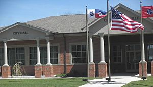
Lobelville City Hall and Library Building
|
|
| Nickname(s):
The Queen City of the Buffalo River
|
|

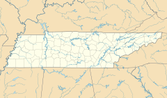
Location of Lobelville in Perry County, Tennessee.
|
|
| Country | United States |
| State | Tennessee |
| County | Perry |
| Established | 1854 |
| Named for | Henri de Lobel, early trader |
| Area | |
| • Total | 3.75 sq mi (9.72 km2) |
| • Land | 3.75 sq mi (9.72 km2) |
| • Water | 0.00 sq mi (0.01 km2) |
| Elevation | 502 ft (153 m) |
| Population
(2020)
|
|
| • Total | 919 |
| • Density | 244.94/sq mi (94.58/km2) |
| Time zone | UTC-6 (Central (CST)) |
| • Summer (DST) | UTC-5 (CDT) |
| ZIP code |
37097
|
| Area code(s) | 931 |
| FIPS code | 47-43160 |
| GNIS feature ID | 1291752 |
Lobelville is a city in Perry County, Tennessee, United States that was established as a trading post on the Buffalo River in 1854. The population was 897 at the 2010 census.
Contents
History
Lobelville was established in 1854 by French trader Henri de Lobel. Originally known as Lobelsville, Lobel established a trading post on the Buffalo River in the early 19th century expecting that it would become a trading route. The proximity of the Tennessee River made this an unprofitable venture, and it never took off as a major trading point.
Geography
Lobelville is located at 35°45′4″N 87°47′35″W / 35.75111°N 87.79306°W (35.751119, -87.793085).
According to the United States Census Bureau, the city has a total area of 3.9 square miles (10 km2), of which, 3.9 square miles (10 km2) of it is land and 0.25% is water.
Lobelville now is the site of a major transfer point on the Tennessee Gas Pipeline Company pipeline network, which is also the oldest continuously operating business in the town, beginning operations in 1943. It is bisected by State Route 13, a connector to Interstate 40 (via exit 143 approximately 10 miles (16 km) north in Humphreys County, Tennessee) and U.S. Route 412 approximately 13 miles (21 km) south in Linden. State Route 438 also passes through the southern part of Lobelville.
Climate
| Climate data for Lobelville, Tennessee, 1991–2020 normals, extremes 1997–present | |||||||||||||
|---|---|---|---|---|---|---|---|---|---|---|---|---|---|
| Month | Jan | Feb | Mar | Apr | May | Jun | Jul | Aug | Sep | Oct | Nov | Dec | Year |
| Record high °F (°C) | 75 (24) |
80 (27) |
87 (31) |
91 (33) |
93 (34) |
107 (42) |
105 (41) |
106 (41) |
100 (38) |
99 (37) |
86 (30) |
78 (26) |
107 (42) |
| Mean maximum °F (°C) | 68.1 (20.1) |
72.3 (22.4) |
80.4 (26.9) |
85.9 (29.9) |
88.9 (31.6) |
94.3 (34.6) |
95.8 (35.4) |
96.7 (35.9) |
92.9 (33.8) |
88.3 (31.3) |
76.9 (24.9) |
70.7 (21.5) |
98.3 (36.8) |
| Mean daily maximum °F (°C) | 48.9 (9.4) |
54.1 (12.3) |
63.1 (17.3) |
72.6 (22.6) |
79.4 (26.3) |
85.6 (29.8) |
89.2 (31.8) |
88.8 (31.6) |
83.3 (28.5) |
73.5 (23.1) |
61.5 (16.4) |
52.6 (11.4) |
71.1 (21.7) |
| Daily mean °F (°C) | 37.7 (3.2) |
41.7 (5.4) |
49.1 (9.5) |
58.1 (14.5) |
66.5 (19.2) |
74.0 (23.3) |
77.9 (25.5) |
76.7 (24.8) |
70.2 (21.2) |
59.0 (15.0) |
47.9 (8.8) |
41.4 (5.2) |
58.4 (14.6) |
| Mean daily minimum °F (°C) | 26.4 (−3.1) |
29.4 (−1.4) |
35.2 (1.8) |
43.6 (6.4) |
53.5 (11.9) |
62.4 (16.9) |
66.6 (19.2) |
64.7 (18.2) |
57.0 (13.9) |
44.5 (6.9) |
34.3 (1.3) |
30.2 (−1.0) |
45.7 (7.6) |
| Mean minimum °F (°C) | 9.6 (−12.4) |
12.9 (−10.6) |
20.5 (−6.4) |
29.5 (−1.4) |
40.3 (4.6) |
51.4 (10.8) |
57.5 (14.2) |
55.1 (12.8) |
45.8 (7.7) |
31.1 (−0.5) |
20.1 (−6.6) |
16.7 (−8.5) |
7.9 (−13.4) |
| Record low °F (°C) | −2 (−19) |
3 (−16) |
5 (−15) |
20 (−7) |
35 (2) |
44 (7) |
53 (12) |
42 (6) |
37 (3) |
25 (−4) |
13 (−11) |
−2 (−19) |
−2 (−19) |
| Average precipitation inches (mm) | 4.42 (112) |
5.87 (149) |
5.12 (130) |
5.54 (141) |
5.53 (140) |
4.23 (107) |
5.19 (132) |
3.64 (92) |
4.19 (106) |
4.57 (116) |
3.69 (94) |
5.30 (135) |
57.29 (1,454) |
| Average precipitation days (≥ 0.01 in) | 8.9 | 8.8 | 10.2 | 9.3 | 9.5 | 8.8 | 8.0 | 7.4 | 6.2 | 6.0 | 8.0 | 9.6 | 100.7 |
| Source 1: NOAA | |||||||||||||
| Source 2: National Weather Service (mean maxima/minima 2006–2020) | |||||||||||||
Demographics
| Historical population | |||
|---|---|---|---|
| Census | Pop. | %± | |
| 1890 | 171 | — | |
| 1960 | 449 | — | |
| 1970 | 773 | 72.2% | |
| 1980 | 993 | 28.5% | |
| 1990 | 830 | −16.4% | |
| 2000 | 915 | 10.2% | |
| 2010 | 897 | −2.0% | |
| 2020 | 919 | 2.5% | |
| Sources: | |||
2020 census
| Race | Number | Percentage |
|---|---|---|
| White (non-Hispanic) | 859 | 93.47% |
| Black or African American (non-Hispanic) | 8 | 0.87% |
| Asian | 4 | 0.44% |
| Other/Mixed | 30 | 3.26% |
| Hispanic or Latino | 18 | 1.96% |
As of the 2020 United States census, there were 919 people, 461 households, and 290 families residing in the city.
Commerce and recreation
The Buffalo River provides a substantial income of tourism through canoeing and fishing, as does the larger Tennessee River. Mousetail Landing State Park is situated south-west of Lobelville in Perry County along the Tennessee River. The Buffalo River Country Club is a local 9-hole semi-private golf course. Hunting, fishing, and camping (both at prepared sites and back-country) are widely available in the area.
Plain community
There is a Plain, Old Order community at Cane Creek, Lobelville, called "Believers in Christ" that is different from other Old Order Mennonite and Amish communities in being rather intentional than traditional. It is in some way similar to communities like the "Christian Communities" of Elmo Stoll, the Caneyville Christian Community and the Noah Hoover Mennonites.
See also
 In Spanish: Lobelville para niños


