Loa River facts for kids
Quick facts for kids Loa |
|
| River | |
|
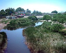
Loa river in Calama
|
|
| Country | Chile |
|---|---|
| Regions | Antofagasta, Tarapacá |
| Provinces | El Loa, Tocopilla, Tamarugal, Iquique |
| Comunas | Ollagüe, Calama, María Elena, Tocopilla, Pica, Pozo Almonte, Iquique |
| Tributaries | |
| - left | San Pedro de Inacaliri, Salado |
| - right | San Salvador |
| City | Calama |
| Source | near the Miño volcano |
| - location | El Loa, Antofagasta, Chile |
| - elevation | 4,277 m (14,032 ft) |
| - coordinates | 21°04′09″S 68°30′27″W / 21.06917°S 68.50750°W |
| Mouth | Pacific Ocean |
| - location | Tamarugal, Tarapacá, Chile |
| - elevation | 0 m (0 ft) |
| - coordinates | 21°25′48″S 70°03′27″W / 21.43000°S 70.05750°W |
| Length | 440 km (273 mi) |
| Basin | 33,570 km² (12,961 sq mi) |
| Discharge | |
| - average | 2.43 m³/s (86 cu ft/s) |
The Loa is a U-shaped river in Chile's northern Antofagasta region. It is the longest river of the country and the main river in the Atacama Desert.
Geography
The Loa river has a length of 440 km (273 mi), and a drainage basin with an area of approximately 33,570 km2 (12,961 sq mi).
Course
The Loa river starts on the Andean mountain slopes at the base of the Miño volcano near the Bolivian border, at an elevation of about 4,277 m (14,032 ft), in the comuna of Ollagüe, Calama, Antofagasta.
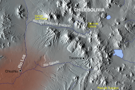
The river flows south, for about 150 km (93.2 mi), to the oasis of San Francisco de Chiu Chiu or simply Chiu Chiu. Two left tributaries joints the Lao river in this part the riverː
- San Pedro de Inacaliri, or simply San Pedro, river. It joints the Loa river before Chiu Chiu.
- Salado river. It joints the Loa river about 3 km (1.9 mi) south of Chiu Chiu.
From Chiu Chiu, the Loa flows to the west, running through the city of Calama. The San Salvador river joints the Loa in this part of course as its only important right tributary.
Then the Loa flows north for about 80 km (49.7 mi) to Quillagua, an oasis in the comuna of María Elena, Tocopilla province in the Antofagasta region of northern Chile. The Loa is crossed by the Pan-American Highway in this area.
From Quillagua, the river turns westward again and marks the border between the regions of Tarapacá and Antofagasta. Finally, the Loa flows in the Pacific Ocean.
Main tributaries
Because the Loa river flows throug a very arid region, a desert, there are very few permanent tributaries; they areː
- Left tributaries
- San Pedro de Inacaliri - 75 km (46.6 mi) long.
- Salado - 80 km (49.7 mi) long.
- Right tributary
- San Salvador - 56 km (34.8 mi) long.
Gallery
Related pages
Images for kids
-
Loa River in Calama
See also
 In Spanish: Río Loa para niños


