List of islands in Shark Bay facts for kids
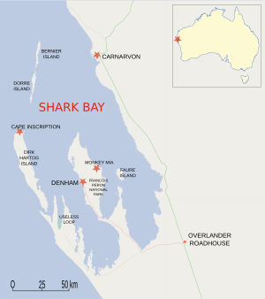
This is a list of the islands in the Shark Bay area of the Gascoyne Region of Western Australia, (between 24°30′0″ and 26°30′0″ S, and 112°0′0″ and 114°30′0″ E).
There are approximately 30 small islands in Shark Bay; all are within the World Heritage Reserve.
The largest is Dirk Hartog Island.
| Island | Area (ha) |
Location | Vicinity |
|---|---|---|---|
| Baudin Island | 20 | 26°30′54″S 113°38′55″E / 26.51500°S 113.64861°E | Henri Freycinet Harbour |
| Bernier Island | 4,000 | 24°50′57″S 113°08′14″E / 24.84917°S 113.13722°E | Bernier Island |
| Charles Island / Charlie Island | 1 | 26°22′03″S 113°34′07″E / 26.36750°S 113.56861°E | Henri Freycinet Harbour |
| Dirk Hartog Island | 63,000 | 25°50′36″S 113°03′18″E / 25.84333°S 113.05500°E | Dirk Hartog Island |
| Dorre Island | 4,900 | 25°03′26″S 113°06′04″E / 25.05722°S 113.10111°E | Bernier Island |
| Double Island | 1 | 26°24′57″S 113°36′59″E / 26.41583°S 113.61639°E | Henri Freycinet Harbour |
| Egg Island | 1 | 25°54′34″S 113°09′20″E / 25.90944°S 113.15556°E | Dirk Hartog Island |
| Faure Island | 5,200 | 25°51′22″S 113°53′35″E / 25.85611°S 113.89306°E | Faure Island |
| Freycinet Island | 3 | 26°24′26″S 113°37′00″E / 26.40722°S 113.61667°E | Henri Freycinet Harbour |
| Friday Island | 1 | 26°06′09″S 113°24′09″E / 26.10250°S 113.40250°E | Freycinet Reach |
| Koks Island | 4 | 24°45′02″S 113°09′33″E / 24.75056°S 113.15917°E | Bernier Island |
| Mary Anne Island | 1 | 26°29′06″S 113°40′59″E / 26.48500°S 113.68306°E | Henri Freycinet Harbour |
| North Guano Island | 6 | 26°31′59″S 113°41′25″E / 26.53306°S 113.69028°E | Henri Freycinet Harbour |
| Pelican Island | 8 | 25°51′12″S 114°00′48″E / 25.85333°S 114.01333°E | Faure Is |
| Salutation Island | 170 | 26°32′22″S 113°45′56″E / 26.53944°S 113.76556°E | Henri Freycinet Harbour |
| South Guano Island | 2 | 26°32′45″S 113°41′26″E / 26.54583°S 113.69056°E | Henri Freycinet Harbour |
| Three Bays Island | 5 | 26°33′15″S 113°38′46″E / 26.55417°S 113.64611°E | Henri Freycinet Harbour |
| White Island | 1 | 26°26′38″S 113°45′41″E / 26.44389°S 113.76139°E | Henri Freycinet Harbour |
| Wilds Island | 1 | 26°27′06″S 113°36′54″E / 26.45167°S 113.61500°E | Henri Freycinet Harbour |
| Ant Island | 26°09′47″S 113°26′32″E / 26.16306°S 113.44222°E | ||
| Babbage Island | 84 | 24°52′39″S 113°37′57″E / 24.87750°S 113.63250°E | Carnarvon |
| Boora Island | 24°45′25″S 114°11′45″E / 24.75694°S 114.19583°E | ||
| Eagle Island | 1 | 26°05′40″S 113°34′30″E / 26.09444°S 113.57500°E | Freycinet Reach |
| Hutchison Islands | 1 | 26°06′47″S 114°14′05″E / 26.11306°S 114.23472°E | Faure Island |
| Kangaroo Island | 1 | 26°19′09″S 113°29′58″E / 26.31917°S 113.49944°E | Henri Freycinet Harbour |
| Lefebre Island | 6 | 26°13′50″S 113°30′25″E / 26.23056°S 113.50694°E | Henri Freycinet Harbour |
| Meade Island | 1 | 26°00′05″S 113°11′57″E / 26.00139°S 113.19917°E | Dirk Hartog Island |
| North Kangaroo Island | 1 | 26°17′57″S 113°30′11″E / 26.29917°S 113.50306°E | Henri Freycinet Harbour |
| Parrot Island | 26°24′45″S 113°30′09″E / 26.41250°S 113.50250°E | ||
| Slope Island | 5 | 26°05′27″S 113°24′45″E / 26.09083°S 113.41250°E | Freycinet Reach |
| Smith Islands | 1 | 26°35′20″S 113°43′35″E / 26.58889°S 113.72639°E | Henri Freycinet Harbour |
| Sunday Island | 26°07′32″S 113°14′06″E / 26.12556°S 113.23500°E | ||
| Unknown Island | 26°23′16″S 113°22′16″E / 26.38778°S 113.37111°E | ||
| Whitlock Island | 24°53′14″S 113°38′44″E / 24.88722°S 113.64556°E | ||
| Whitmore Island | 24°52′00″S 113°37′20″E / 24.86667°S 113.62222°E | ||
| Wilson Island | 26°09′55″S 113°39′33″E / 26.16528°S 113.65917°E |
See also
- List of islands of Western Australia

All content from Kiddle encyclopedia articles (including the article images and facts) can be freely used under Attribution-ShareAlike license, unless stated otherwise. Cite this article:
List of islands in Shark Bay Facts for Kids. Kiddle Encyclopedia.

