Lesser Slave Lake facts for kids
This page is about the lake in Alberta. For the electoral district, see Lesser Slave Lake (electoral district). For the lake in the Northwest Territories, see Great Slave Lake.
Quick facts for kids Lesser Slave Lake |
|
|---|---|

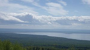
Southeast corner of the lake from Marten Mountain looking south with Dog Island, Devonshire Beach, and the Town of Slave Lake visible in the distance
|
|
| Location | Big Lakes / Lesser Slave River No. 124, Alberta |
| Coordinates | 55°26′26″N 115°29′19″W / 55.44056°N 115.48861°W |
| Type | Eutrophic |
| Primary inflows | South Heart River, Swan River Driftpile River, Assineau River, Marten River |
| Primary outflows | Lesser Slave River |
| Catchment area | 13,900 km2 (5,400 sq mi) |
| Basin countries | Canada |
| Max. length | +100 km (62 mi) |
| Max. width | 15 km (9.3 mi) |
| Surface area | 1,168 km2 (451 sq mi) |
| Average depth | 11.4 m (37 ft) |
| Max. depth | 20.5 m (67 ft) |
| Water volume | 13.69 km3 (11.10×10⁶ acre⋅ft) |
| Shore length1 | 247 km (153 mi) |
| Surface elevation | 578 m (1,896 ft) |
| Settlements | Slave Lake, High Prairie, Alberta |
| 1 Shore length is not a well-defined measure. | |
Lesser Slave Lake is located in central Alberta, Canada, northwest of Edmonton. It is the second largest lake entirely within Alberta boundaries (and the largest easily accessible by vehicle), covering 1,160 km2 (450 sq mi) and measuring over 100 km (62 mi) long and 15 km (9.3 mi) at its widest point. Lesser Slave Lake averages 11.4 m (37 ft) in depth and is 20.5 m (67 ft) at its deepest. It drains eastwards into the Athabasca River by way of the Lesser Slave River.
The town of Slave Lake is located at the eastern tip of the lake, around the outflow of Lesser Slave River.
Images for kids
See also
 In Spanish: Pequeño Lago de los Esclavos para niños

All content from Kiddle encyclopedia articles (including the article images and facts) can be freely used under Attribution-ShareAlike license, unless stated otherwise. Cite this article:
Lesser Slave Lake Facts for Kids. Kiddle Encyclopedia.


