Lerum Municipality facts for kids
Quick facts for kids
Lerum Municipality
Lerums kommun
|
||
|---|---|---|

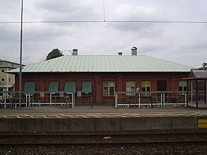
Lerum Railway Station
|
||
|
||
 |
||
| Country | Sweden | |
| County | Västra Götaland County | |
| Seat | Lerum | |
| Area | ||
| • Total | 310.2 km2 (119.8 sq mi) | |
| • Land | 260.29 km2 (100.50 sq mi) | |
| • Water | 49.91 km2 (19.27 sq mi) | |
| Area as of January 1, 2010. | ||
| Population
(June 30, 2012)
|
||
| • Total | 38,491 | |
| • Density | 124.084/km2 (321.38/sq mi) | |
| Time zone | UTC+1 (CET) | |
| • Summer (DST) | UTC+2 (CEST) | |
| ISO 3166 code | SE | |
| Province | Västergötland | |
| Municipal code | 1441 | |
| Website | www.lerum.se | |
| Density is calculated using land area only. | ||
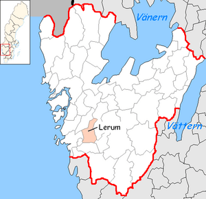
Lerum Municipality (Lerums kommun) is a municipality in Västra Götaland County in western Sweden, situated just east of Gothenburg. Its seat is located in the town of Lerum.
In 1969 the municipality got its present size when "old" Lerum was amalgamated with Skallsjö and Stora Lundby.
In 2007, Lerum Municipality launched a new logotype to be used instead of its official municipal coat of arms which features the head of an ox and three oak leaves. Municipal officials and PR staff felt the coat "outdated". Although no longer used, the coat of arms still has official status. The new logotype features a multi-coloured weaving pattern.
Localities
- Floda
- Gråbo
- Lerum (seat)
- Norsesund (partly)
- Stenkullen
- Tollered
Demographics
This is a demographic table based on Lerum Municipality's electoral districts in the 2022 Swedish general election sourced from SVT's election platform, in turn taken from SCB official statistics.
In total there were 43,372 residents, including 31,378 Swedish citizens of voting age. 45.1% voted for the left coalition and 54.0% for the right coalition. Indicators are in percentage points except population totals and income.
| Location | Residents | Citizen adults |
Left vote | Right vote | Employed | Swedish parents |
Foreign heritage |
Income SEK |
Degree |
|---|---|---|---|---|---|---|---|---|---|
| % | % | ||||||||
| Aggetorp-Björboholm | 2,110 | 1,483 | 43.3 | 55.5 | 86 | 80 | 20 | 30,642 | 42 |
| Berghult-Ryggebol | 1,215 | 906 | 40.2 | 59.0 | 86 | 85 | 15 | 30,754 | 43 |
| Brattås-Hjällsnäs | 1,516 | 1,148 | 43.8 | 54.6 | 87 | 85 | 15 | 29,148 | 40 |
| C Floda-Nordåsen | 1,779 | 1,329 | 47.3 | 52.4 | 83 | 84 | 16 | 29,666 | 49 |
| Centrala Gråbo | 2,427 | 1,773 | 43.8 | 54.4 | 80 | 72 | 28 | 24,786 | 31 |
| Centrala Lerum | 1,287 | 1,120 | 44.5 | 54.4 | 80 | 84 | 16 | 24,443 | 45 |
| Drängsered-Hästhagen | 1,893 | 1,348 | 49.1 | 49.4 | 86 | 88 | 12 | 29,336 | 52 |
| Hyltorna-Öjared | 1,780 | 1,328 | 48.6 | 50.6 | 84 | 87 | 13 | 29,464 | 55 |
| Kyrkmossen-Lindskogen | 1,490 | 1,000 | 39.7 | 59.7 | 87 | 86 | 14 | 31,420 | 45 |
| Ljungsbacken-Stamsjön | 2,249 | 1,560 | 40.4 | 58.8 | 91 | 91 | 9 | 39,527 | 72 |
| N Aspenäs-Axåsen | 1,707 | 1,264 | 41.3 | 58.1 | 89 | 89 | 11 | 36,892 | 65 |
| N Hallsås-Höjden | 2,331 | 1,598 | 42.3 | 56.9 | 88 | 85 | 15 | 31,962 | 56 |
| Olstorp | 1,745 | 1,233 | 40.3 | 59.0 | 88 | 82 | 18 | 31,797 | 41 |
| Rydsberg-Almekärr | 2,037 | 1,423 | 43.9 | 55.6 | 85 | 87 | 13 | 32,412 | 60 |
| Sjövik | 1,584 | 1,108 | 46.7 | 52.0 | 80 | 76 | 24 | 25,607 | 35 |
| Stannum-Ljungvik | 1,351 | 1,004 | 43.1 | 55.7 | 87 | 86 | 14 | 27,934 | 35 |
| Stenkullen-Hedefors | 2,240 | 1,576 | 48.5 | 50.4 | 84 | 82 | 18 | 27,760 | 43 |
| S Aspenäs-Torpadal | 2,065 | 1,505 | 40.3 | 59.2 | 87 | 90 | 10 | 36,097 | 68 |
| Södra Hallsås | 1,916 | 1,454 | 51.2 | 48.4 | 87 | 89 | 11 | 30,126 | 60 |
| S Lerum-Slätthult | 2,076 | 1,507 | 40.4 | 58.7 | 89 | 92 | 8 | 33,073 | 56 |
| Tollered-Norsesund | 1,481 | 1,078 | 57.2 | 42.3 | 85 | 88 | 12 | 29,547 | 54 |
| Uddared-Oryd | 1,700 | 1,174 | 53.3 | 45.4 | 88 | 91 | 9 | 33,182 | 64 |
| V Hulan-Bråta | 1,657 | 1,243 | 47.7 | 51.0 | 83 | 82 | 18 | 29,493 | 55 |
| Ö Hylan-Öxeryd | 1,736 | 1,216 | 47.7 | 51.0 | 88 | 86 | 14 | 32,572 | 52 |
| Source: SVT | |||||||||
See also
 In Spanish: Municipio de Lerum para niños


