Leduc County facts for kids
Quick facts for kids
Leduc County
|
||
|---|---|---|

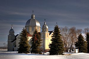
St John the Baptist Church in Leduc County south of Thorsby
|
||
|
||

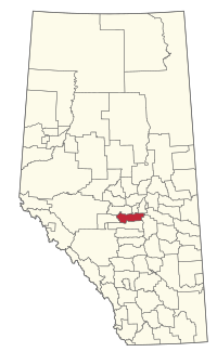
Location within Alberta
|
||
| Country | Canada | |
| Province | Alberta | |
| Region | Edmonton Metropolitan Region | |
| Census division | 11 | |
| Established | 1944 | |
| Incorporated | 1964 | |
| Area
(2021)
|
||
| • Land | 2,502.59 km2 (966.26 sq mi) | |
| Population
(2021)
|
||
| • Total | 14,416 | |
| • Density | 5.8/km2 (15/sq mi) | |
| Time zone | UTC-7 (MST) | |
| • Summer (DST) | UTC-6 (MDT) | |
Leduc County is a municipal district in Alberta, Canada that is immediately south of the City of Edmonton. It spans 105 km (65 mi) east to west and 32 km (20 mi) north to south, and has a population of 14,416. The municipal district is home to prairie parkland and several lakes and is home to the Edmonton International Airport, the Nisku Industrial Business Park and the Genesee Generating Station.
Geography
Communities and localities
|
The following urban municipalities are surrounded by Leduc County.
|
The following hamlets are located within Leduc County.
|
The following localities are located within Leduc County.
- Localities
|
|
|
|
- Other places
- East Vistas (new urban community approved September 28, 2010)
Demographics
In the 2021 Census of Population conducted by Statistics Canada, Leduc County had a population of 14,416 living in 5,295 of its 5,990 total private dwellings, a change of 9.4% from its 2016 population of 13,177. With a land area of 2,502.59 km2 (966.26 sq mi), it had a population density of 5.8/km2 (15/sq mi) in 2021.
In the 2016 Census of Population conducted by Statistics Canada, Leduc County had a population of 13,780 living in 5,101 of its 5,960 total private dwellings, a 2.1% change from its 2011 population of 13,494. With a land area of 2,601.49 km2 (1,004.44 sq mi), it had a population density of 5.3/km2 (14/sq mi) in 2016.


