LeRoy Township, Lake County, Ohio facts for kids
Quick facts for kids
Leroy Township, Lake County, Ohio
|
|
|---|---|

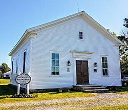
South Leroy Meetinghouse
|
|

Location of LeRoy Township in Lake County
|
|
| Country | United States |
| State | Ohio |
| County | Lake |
| Area | |
| • Total | 25.5 sq mi (66.1 km2) |
| • Land | 25.4 sq mi (65.8 km2) |
| • Water | 0.1 sq mi (0.3 km2) |
| Elevation | 955 ft (291 m) |
| Population
(2020)
|
|
| • Total | 3,128 |
| • Density | 122.56/sq mi (47.32/km2) |
| Time zone | UTC-5 (Eastern (EST)) |
| • Summer (DST) | UTC-4 (EDT) |
| FIPS code | 39-42812 |
| GNIS feature ID | 1086422 |
LeRoy Township is one of the five townships of Lake County, Ohio, United States. As of the 2020 census the population was 3,128.
Geography
Located in the eastern part of the county, it borders the following townships:
- Perry Township - north
- Madison Township - northeast
- Thompson Township, Geauga County - east
- Montville Township, Geauga County - southeast corner
- Hambden Township, Geauga County - south
- Concord Township - west
- Painesville Township - northwest corner
No municipalities are located in LeRoy Township.
According to the U.S. Census Bureau, the total area of LeRoy Township is 25.5 square miles (66.1 km2), of which 25.4 square miles (65.8 km2) are land and 0.1 square miles (0.3 km2), or 0.50%, are water. The Grand River forms the northern boundary of the township.
Name and history
Named for Le Roy, New York, the home of many of the township's earliest settlers, it is the only LeRoy Township statewide. Its name is often spelled "Leroy" and sometimes "Le Roy."
The first settlers in what is now LeRoy Township were Paul and Elijah Clapp, who arrived in 1802. LeRoy Township was established in 1820, but it was not made part of Lake County until 1840. During the Civil War, forty men from LeRoy Township served in the Union Army.
The January 1986 Northeastern Ohio earthquake occurred in the southwestern portion of the township.
See also
 In Spanish: Municipio de LeRoy (Ohio) para niños

