Lawrence County, Pennsylvania facts for kids
Quick facts for kids
Lawrence County
|
|||
|---|---|---|---|
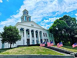
Lawrence County Courthouse
|
|||
|
|||
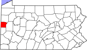
Location within the U.S. state of Pennsylvania
|
|||
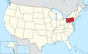 Pennsylvania's location within the U.S. |
|||
| Country | |||
| State | |||
| Founded | March 20, 1849 | ||
| Named for | USS Lawrence | ||
| Seat | New Castle | ||
| Largest city | New Castle | ||
| Area | |||
| • Total | 363 sq mi (940 km2) | ||
| • Land | 358 sq mi (930 km2) | ||
| • Water | 4.5 sq mi (12 km2) 1.3% | ||
| Population
(2020)
|
|||
| • Total | 86,070 | ||
| • Density | 240/sq mi (90/km2) | ||
| Time zone | UTC−5 (Eastern) | ||
| • Summer (DST) | UTC−4 (EDT) | ||
| Congressional district | 16th | ||
Lawrence County is a county in the Commonwealth of Pennsylvania. As of the 2020 census, the population was 86,070. The county seat and largest city is New Castle.
The county was created on March 20, 1849, from parts of Beaver and Mercer counties. The county is part of the Greater Pittsburgh region of the state.
Contents
History
Lawrence County was created on March 20, 1849, from parts of Beaver and Mercer counties due to the rapid growth of New Castle, which was primarily in Mercer County but was rapidly expanding into Beaver County. The former borders between Beaver and Mercer Counties are still evident in Lawrence County today, as the northern borders of North Beaver Township, Shenango Township, and Slippery Rock Township with (respectively) the southern borders of Mahoning Township, Hickory Township, and Scott Township make up the former boundaries between Beaver and Mercer Counties. In addition, County Line Road in New Castle where the Lawrence County Courthouse is located also marks the former boundaries.
The county was named after the flagship of Commodore Oliver Hazard Perry, the USS Lawrence, which was disabled in the September 10, 1813 Battle of Lake Erie during the War of 1812. The ship's complement included local raw recruits. That niagara-class brig (more correctly: snow) was itself a namesake, of Perry's friend and naval officer James Lawrence, who died during the War of 1812.
Lawrence County Flag
In August 1981, county commissioner Paul L. Tanner proposed the creation of a flag for Lawrence County as well as a flag for each of the county's 27 municipalities These were to be displayed at the courthouse. Over the next few months, flags for Perry Township, New Beaver Borough, and Wampum Borough were presented to the commissioners
On January 12, 1982, commissioner chairman, Frank A. Vitril, announced a county flag design contest and asked residents of Lawrence County to submit entries on an 8.5 by 11 inch sheet of paper with their name, address, and telephone number on an attached sheet of paper. The winner would receive $100 prize contributed in equal parts from the county commissioners and would not come from taxpayers. They also announced the formation of a committee, coordinated by the Lawrence County Planning Commission, to select the winner. The commissioners said in a statement, "As public officials, we are aware of the need to generate public spirit and interest in the affairs of local government. The promotion of a county flag will enable interested citizens (schools, art groups, etc.) of Lawrence County participation in an historic event."
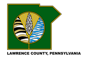
The winning flag was announced on June 4, 1982, and a ceremony was held at the courthouse on June 15, 1982, in observance of Flag Day, as the courthouse was closed on June 14. Rosemary Ann Marino, a commercial artist from New Castle, submitted several designs and her winning entry was one of 43 designs submitted by 15 individuals. The design depicts the shape of Lawrence County in green and edged with gold off-center on a white background with the words "Lawrence County, Pennsylvania" emblazoned on the bottom. The center logo features a shaft of wheat, symbolizing prosperity, against a background of rolling farmlands on the left and waves of water on the right. Marino received a check for $100 at a ceremony at the courthouse as well as a telegraph from Governor Dick Thornburgh who congratulated Lawrence County on its new flag.
A painting of the design was revealed at the ceremony and was painted on masonite by Harry Broschart, who was on the flag selection committee. He and other committee members, Dominic Caminite and former director of arts and crafts at West Side Community Center, Virginia Rankin, gave the award presentations. Honorable mentions included a covered bridge design by Grayce D. Sharek, a blue and gold circular design stating "Lawrence County, Government for the People, founded 1849" by Betty Stone, an outline of the courthouse against a red keystone on a blue background by Steve T. Grala, and a two-tone green flag with an outline of the county by James E. Hamilton. Entries were judged based on originality, creativity, theme, clarity, and design.
President Judge Glenn McCracken offered remarks urging those present to take pride in their home, Lawrence County, and the flag which symbolizes it, and saying Lawrence County needs the kind of American pride in their heredity that was reawakened by the television show Roots.
Geography
According to the U.S. Census Bureau, the county has a total area of 363 square miles (940 km2), of which 358 square miles (930 km2) is land and 4.5 square miles (12 km2) (1.3%) is water. Major waterways are the Shenango River, Neshannock Creek and the Mahoning River which form the Beaver River. Also, the Slippery Rock Creek and Connoquenessing Creak empty into the Beaver River. Lawrence County is one of the 423 counties served by the Appalachian Regional Commission, and it is identified as part of the "Midlands" by Colin Woodard in his book American Nations: A History of the Eleven Rival Regional Cultures of North America.
Climate
Lawrence County has a humid continental climate (Dfa/Dfb) and average monthly temperatures in New Castle range from 27.7 °F in January to 72.2 °F in July.
Adjacent counties
- Mercer County (north)
- Butler County (east)
- Beaver County (south)
- Columbiana County, Ohio (southwest)
- Mahoning County, Ohio (west)
Demographics
| Historical population | |||
|---|---|---|---|
| Census | Pop. | %± | |
| 1850 | 21,079 | — | |
| 1860 | 22,999 | 9.1% | |
| 1870 | 27,298 | 18.7% | |
| 1880 | 33,312 | 22.0% | |
| 1890 | 37,517 | 12.6% | |
| 1900 | 57,042 | 52.0% | |
| 1910 | 70,032 | 22.8% | |
| 1920 | 85,545 | 22.2% | |
| 1930 | 97,258 | 13.7% | |
| 1940 | 96,877 | −0.4% | |
| 1950 | 105,120 | 8.5% | |
| 1960 | 112,965 | 7.5% | |
| 1970 | 107,374 | −4.9% | |
| 1980 | 107,150 | −0.2% | |
| 1990 | 96,246 | −10.2% | |
| 2000 | 94,639 | −1.7% | |
| 2010 | 91,108 | −3.7% | |
| 2020 | 86,070 | −5.5% | |
As of the 2000 census there were 94,643 people, 37,091 households, and 25,889 families residing in the county. The population density was 263 inhabitants per square mile (102/km2). There were 39,635 housing units at an average density of 110 units per square mile (42/km2). The racial makeup of the county was 94.98% White, 3.61% Black or African American, 0.10% Native American, 0.27% Asian, 0.01% Pacific Islander, 0.19% from other races, and 0.84% from two or more races. 0.56% of the population were Hispanic or Latino of any race. 34.2% English or Welsh, 14.6% were of Italian, 12.4% American, 9.0% German, 8.1% Irish, and 6.8% Scotch-Irish, 2.5% Polish, and 1.9% African ancestry.
There were 37,091 households, out of which 28.80% had children under the age of 18 living with them, 54.50% were married couples living together, 11.50% had a female householder with no husband present, and 30.20% were non-families. 27.00% of all households were made up of individuals, and 14.40% had someone living alone who was 65 years of age or older. The average household size was 2.47 and the average family size was 3.00.
In the county, the population was spread out, with 23.10% under the age of 18, 8.30% from 18 to 24, 25.70% from 25 to 44, 23.60% from 45 to 64, and 19.30% who were 65 years of age or older. The median age was 40 years. For every 100 females, there were 90.60 males. For every 100 females age 18 and over, there were 86.90 males.
2020 census
| Race | Num. | Perc. |
|---|---|---|
| White (NH) | 75,811 | 88.1% |
| Black or African American (NH) | 3,546 | 4.12% |
| Native American (NH) | 75 | 0.1% |
| Asian (NH) | 321 | 0.37% |
| Pacific Islander (NH) | 4 | 0.01% |
| Other/Mixed (NH) | 4,658 | 5.4% |
| Hispanic or Latino | 1,655 | 2% |
Micropolitan Statistical Area
The United States Office of Management and Budget has designated Lawrence County as the New Castle, PA Micropolitan Statistical Area (MSA). As of the 2010 U.S. census the micropolitan area ranked 3rd most populous in the State of Pennsylvania and the 48th most populous in the United States with a population of 91,108. Lawrence County is also a part of the Pittsburgh–New Castle–Weirton combined statistical area (CSA), which combines the population of Lawrence, and Allegheny, Armstrong, Beaver, Butler, Fayette, Indiana, Washington, and Westmoreland Counties in Pennsylvania. In West Virginia, the counties included are Brooke and Hancock. And in Ohio, Jefferson County. The combined statistical area ranked the fourth most populous in Pennsylvania and 20th most populous in the U.S. with a population of 2,660,727.
Education
Colleges and universities
- Westminster College - New Wilmington
Community, junior, and technical colleges
- Butler Community College Lawrence Crossing Campus
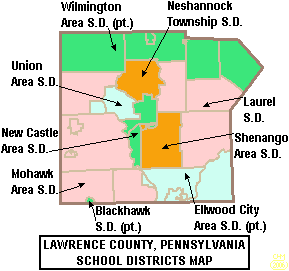
Public school districts
- Blackhawk School District (part)
- Ellwood City Area School District (part)
- Laurel School District
- Mohawk Area School District
- Neshannock Township School District
- New Castle Area School District
- Shenango School District
- Union Area School District
- Wilmington Area School District (part)
Tech schools
- Lawrence County Career Technology Center - Shenango Township
- New Castle School of Trades - Union Township
Private schools
- Apple Grove School - New Wilmington
- Cherry Hill School - New Wilmington
- Cotton School - New Wilmington
- Ellwood City Children's Center, Inc.
- Faith Country Chapel Preschool and Kindergarten - New Castle
- Fayette School - Volant
- Hillside Parochial School - New Wilmington
- Indian Run School - New Wilmington
- J R Wilson School - New Wilmington
- Ligo School - New Wilmington
- Little Beaver Parochial School - Enon Valley
- Lusk School - Volant
- Meadow Lark School - New Wilmington
- New Castle Christian Academy - New Castle
- Parents Preschool Ellwood City
- Shepherd School - Volant
- St Vitus Catholic School - New Castle
- Thorn Hill School - Volant
- Westminster Preschool - New Wilmington
Per data provided at Pennsylvania EdNA
Libraries
- Ellwood City Area Public Library
- F D Campbell Memorial Library - Bessemer
- Lawrence County Federated Library System - New Castle
- New Castle Public Library
Transportation
Airports
- New Castle Municipal Airport
Public transit
- New Castle Area Transit Authority
Major roads and highways

 I-76 / Penna Turnpike
 I-79
I-79 I-376
I-376 US 19
US 19 US 224
 US 422


 US 422 Bus.
 PA 18
PA 18 PA 65
PA 65 PA 108
 PA 158
 PA 168
 PA 208
 PA 288
 PA 317
 PA 351
 PA 388
 PA 488
 PA 551
 PA 956
Recreation
Parks
- Cascade Park (New Castle)
- Ewing Park (Ellwood City)
- Gaston Park (New Castle)
- McConnells Mill State Park (Slippery Rock Twp)
- Pearson Park (Neshannock Twp)
- West Park Nature Center (Union Twp)
- Marti Park
- New Wilmington Borough Park
State game lands
- SGL 148 (New Beaver)
- SGL 150 (Pulaski Twp)
- SGL 151 (Washington Twp near Volant)
- SGL 178 (Neshannock Twp north of New Castle)
- SGL 216 (Scott Twp near Harlansburg)
Trails
- North Country Trail (entire trail)
- North Country Trail (local)
- Stavich Bike Trail
- Neshannock Creek Trail
Communities
Under Pennsylvania law, there are four types of incorporated municipalities: cities, boroughs, townships, and, in at most two cases, towns. The following cities, boroughs and townships are located in Lawrence County:
Cities
- New Castle (county seat)
Boroughs
Townships
- Hickory
- Little Beaver
- Mahoning
- Neshannock
- North Beaver
- Perry
- Plain Grove
- Pulaski
- Scott
- Shenango
- Slippery Rock
- Taylor
- Union
- Washington
- Wayne
- Wilmington
Census-designated places
Census-designated places are geographical areas designated by the U.S. Census Bureau for the purposes of compiling demographic data. They are not actual jurisdictions under Pennsylvania law. Other unincorporated communities, such as villages, may be listed here as well.
Unincorporated communities
Various unincorporated communities that lie within and are part of official municipalities.
- Altman
- Belmar Park
- Brent
- Burnstown
- Castlewood
- Coaltown
- Coaltown Hill
- Cottage Grove
- Coverts
- Derringer Corners
- Drake
- Duckrun
- Eastbrook
- East New Castle
- Edinburg
- Elliott Mills
- Energy
- Fayette
- Gibsondale
- Grant City
- Harbor
- Harbor Bridge
- Harlansburg
- Hillsville
- Jackson Knolls Gardens
- Joyce
- Lawrence Junction
- Mahoningtown
- McCaslin
- McConnells Mill
- Moravia
- Mount Air
- Mount Jackson
- Nashua
- Neshannock Falls
- New Castle Junction
- Newburg
- Newpoint
- North Edinburg
- Old Enon
- Park Gate
- Parkstown
- Peanut
- Possum Hollow
- Princeton
- Pulaski
- Robinson
- Rockville
- Rose Point
- Sheep Hill
- Skidmore
- Sunnyside
- Sunset Valley
- Villa Maria
- Walmo
- Westview Heights
- Wiegletown
- Willow Grove
- Wurtemburg
Former community
- Big Beaver Borough became a borough on March 7, 1958. Until that date, it was known as Big Beaver Township, which was formed in 1802 when South Beaver Township was divided. In 1849, when Lawrence County was created, the new county line split Big Beaver leaving a township of that name in each county. Big Beaver in Lawrence County is now known as New Beaver Borough.
Population ranking
The population ranking of the following table is based on the 2010 census of Lawrence County.
† county seat
| Rank | City/Town/etc. | Municipal type | Population (2010 Census) |
|---|---|---|---|
| 1 | † New Castle | City | 23,273 |
| 2 | Ellwood City (partially in Beaver County) | Borough | 7,921 |
| 3 | New Wilmington | Borough | 2,466 |
| 4 | Oakwood | CDP | 2,270 |
| 5 | Oakland | CDP | 1,569 |
| 6 | New Beaver | Borough | 1,502 |
| 7 | New Castle Northwest | CDP | 1,413 |
| 8 | Ellport | Borough | 1,180 |
| 9 | Bessemer | Borough | 1,111 |
| 10 | New Bedford | CDP | 925 |
| 11 | West Pittsburg | CDP | 808 |
| 12 | Wampum | Borough | 717 |
| 13 | South New Castle | Borough | 709 |
| 14 | Frizzleburg | CDP | 602 |
| 15 | Chewton | CDP | 488 |
| 16 | Enon Valley | Borough | 306 |
| 17 | Volant | Borough | 168 |
| 18 | S.N.P.J. | Borough | 19 |
Notable people
- W. Thomas Andrews – former Pennsylvania state senator
- Joseph Baldwin – educator
- Charlie Bennett – Major League Baseball catcher for four teams
- John Blangero – human geneticist; highly cited scientist in the field of complex disease genetics
- Charles Joseph Carter – magician
- George Chip – middleweight boxing champion of the world from 1913 to 1914
- William C. Chip – Major general, USMC, son of George Chip
- Ben Ciccone – NFL player for the Pittsburgh Steelers
- Ralph J. Cicerone – scientist, president of the National Academy of Sciences
- Bruce Clark – professional football player with the New Orleans Saints and Kansas City Chiefs and Penn State All-American
- Jack Cole – cartoonist and creator of the superhero Plastic Man
- Paul Cuba – American football player
- Nick DeCarbo – NFL player
- Matt DeSalvo – Major League Baseball starting pitcher with the Florida Marlins and formerly the New York Yankees and Atlanta Braves
- Darrell Dess – former football player for the Pittsburgh Steelers, the New York Giants, and the Washington Redskins
- Thomas Fee – former member of the U.S. House of Representatives
- Israel Gaither – National Commander of The Salvation Army in the United States, the first black person to serve in that capacity
- Helen Thornton Geer – prominent librarian and academic
- Louis E. Graham – former member of the U.S. House of Representatives
- Edmond Hamilton – prolific science fiction author writing chiefly in the genre described as space opera
- Gabbie Hanna – YouTuber, singer and author
- Malik Hooker – Indianapolis Colts safety, drafted 15th pick in 2017
- Donnie Iris – rock singer and guitarist, best known for his work with the Jaggerz, Wild Cherry and Donnie Iris and the Cruisers.
- Francis Jackson – born free (circa 1815 to 1820), he was kidnapped in 1850 and sold into slavery and was finally freed in 1855 with the resolution of Francis Jackson v. John W. Deshazer.
- Oscar Lawrence Jackson – former member of the U.S. House of Representatives
- Charles McMeen Kurtz – art critic, writer, museum curator
- Donald N. Levine – sociologist, educator, social theorist and writer
- Mark Mangino – former head coach of the University of Kansas football team
- Mike Marshall – musician
- Scott McCurley – NFL assistant coach with the Green Bay Packers
- Bill McPeak – football player and National Football League coach
- Andrew R. Morgan – US astronaut, selected in 2013
- Lance Nimmo – NFL player with Tampa Bay Buccaneers, New York Jets, Cleveland Browns, New England Patriots
- Thomas Wharton Phillips – former member of the U.S. House of Representatives
- Rick Razzano – professional football player
- Trent Reznor – lead singer for industrial rock band Nine Inch Nails
- Christopher Sainato – former member of the Pennsylvania House of Representatives
- Ira D. Sankey – gospel singer and composer
- Raymond P. Shafer – 39th governor of Pennsylvania from 1967 to 1971
- Frank Shields – former Oregon state senator
- John W. Slayton – prominent socialist and labor union leader
- Robert Sterling – film and television actor who starred in many films including the 1951 MGM hit Show Boat
- Chuck Tanner – former left fielder and manager in Major League Baseball, and skipper of the Pittsburgh Pirates' 1979 World Series champion team
- George Zambelli Sr. – American fireworks entertainer, and long-time president and manager of Zambelli Fireworks
- Jack Zduriencik – Seattle Mariners general manager, former Pittsburgh Pirates scout
See also
 In Spanish: Condado de Lawrence (Pensilvania) para niños


