Larkin State Park Trail facts for kids
Quick facts for kids Larkin State Park Trail |
|
|---|---|

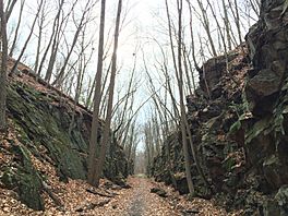
Looking west on the trail in Middlebury
|
|
| Length | 10.3 miles (16.6 km) |
| Location | Southbury, Oxford, Middlebury, and Naugatuck, Connecticut |
| Established | 1943 |
| Designation | Connecticut state park |
| Trailheads | Southbury (41°28′20″N 73°12′25″W / 41.47234°N 73.20691°W) Naugatuck (41°30′45″N 73°03′56″W / 41.51246°N 73.06556°W) |
| Use | Hiking, biking, horseback riding, cross-country skiing |
| Sights | Woodlands, horse farms, ponds, wetlands |
| Surface | Various: sand, packed dirt and cobbles, railroad ballast and cinders |
| Maintained by | Connecticut Department of Energy and Environmental Protection |
| Website | Larkin State Park Trail |
Larkin State Park Trail is a Connecticut rail trail that follows the former New York & New England Railroad roadbed across the towns of Southbury, Oxford, Middlebury, and Naugatuck. The trail is 10.3 miles (16.6 km) long; its eastern terminus is at Whittemore Glen State Park, the western at Kettletown Road in Southbury. The trail is open for hiking, biking, horseback riding, and cross-country skiing.
History
The rail line was in operation from 1881 until 1939. Four years after the line's abandonment, Dr. Charles L. Larkin bought a ten-mile section that he donated to the state for the purpose of creating an equestrian trail. The park was named in his honor.

All content from Kiddle encyclopedia articles (including the article images and facts) can be freely used under Attribution-ShareAlike license, unless stated otherwise. Cite this article:
Larkin State Park Trail Facts for Kids. Kiddle Encyclopedia.
