Lake Pontchartrain facts for kids
Quick facts for kids Lake Pontchartrain |
|
|---|---|

Landsat image
|
|

Map
|
|
| Coordinates | |
| Type | salt-water lake |
| Basin countries | United States |
| Surface area | 630 sq mi (1630 km²) |
| Settlements | New Orleans, Metairie, Kenner, Mandeville, Slidell, Madisonville, etc. |
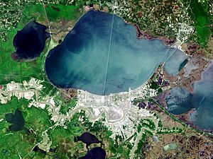
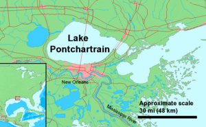
Lake Pontchartrain (pronounced /ˈpɒntʃətreɪn/ in English; Lac Pontchartrain, IPA [lak pɔ̃ʃaʀtʀɛ̃] in French) is a brackish lake in southeastern Louisiana. It is the second largest salt-water lake in the United States, after the Great Salt Lake in Utah, and the largest lake in Louisiana.
It has an area of 630 square miles (1630 square km) with an average depth of 12 to 14 feet (about 4 meters). Some shipping channels are kept deeper through dredging. It is roughly oval in shape, about 40 miles (64 km) wide and 24 miles (39 km) from south to north.
Images for kids
-
Lake Pontchartrain from southbound causeway entrance
-
Lake Pontchartrain's north shore at Fontainebleau State Park near Mandeville, Louisiana, in 2004
-
At the southern terminus of LA 1077 in Madisonville, this lighthouse is on the west estuary of the Tchefuncte River at Lake Pontchartrain and was constructed in 1837.
-
Lake Pontchartrain at New Orleans during Hurricane Georges in 1998; lakefront fishing camps outside of the protection levee suffered severe damage.
-
Windspeed of Hurricane Katrina 7 a.m., showing hurricane-force winds (yellow/brown/red: 75-92 mph) hitting the northeast–south shores of Lake Pontchartrain (1 hour after landfall) on August 29, 2005.
See also
 In Spanish: Lago Pontchartrain para niños


