
Lake Moawhango facts for kids
Quick facts for kids Lake Moawhango |
|
|---|---|

Lake Moawhango
Location in North Island
|
|
| Location | Waiouru, North Island |
| Coordinates | 39°23′35″S 175°45′11″E / 39.393°S 175.753°E |
| Primary outflows | Moawhango Tunnel to Tongariro River |
| Basin countries | New Zealand |
Lake Moawhango is a small artificial lake located with the New Zealand Army's Waiouru Military Camp. It is fed by the Mangaio Stream, boosted by tributaries diverted from the slopes of Mt Ruapehu, and by the Moawhango River. Water is taken from the lake for the Tongariro Power Scheme, feeding the Tongariro River via the Moawhango Tunnel, although some water is released to continue down the Moawhango River nearby the settlement of Moawhango. The lake is dammed at the southern end.
Lake Moawhango contains a large population of wild rainbow trout, and while these are easily caught, they very rarely exceed 2 pounds (0.9 kg) in weight. The lake contains three islands, the largest of which is known as Ayers Rock.
The exact antipodes of this lake coincide exactly with the dam of Torre de Abraham, in Castilla - La Mancha, Spain (at coordinates 39°22′06″N 4°15′12″W / 39.3684°N 4.2534°W).
Images for kids
-
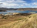
Lake Moawhango from west side looking east, January 2022
-
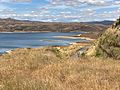
Lake Moawhango looking south towards Moawhango Dam, January 2022
-
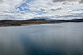
Lake Moawhango looking north west to Mt Ruapehu, January 2022
-
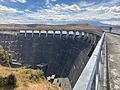
Lake Moawhango and Mt Ruapehu from the Moawhango Dam, January 2022


